Category:Kerpener Straße (Köln)
Jump to navigation
Jump to search
| Object location | | View all coordinates using: OpenStreetMap |
|---|
street in Cologne, Germany | |||||
| Upload media | |||||
| Instance of | |||||
|---|---|---|---|---|---|
| Location | Cologne, Cologne Government Region, North Rhine-Westphalia, Germany | ||||
| Connects with | |||||
 | |||||
Subcategories
This category has the following 6 subcategories, out of 6 total.
A
- Aufbrechende Frucht (3 F)
F
- Frauenklinik, Uniklinik Köln (15 F)
G
- Geusenfriedhof (1 P, 130 F)
H
- Herzzentrum, Uniklinik Köln (3 F)
K
- Kerpener Straße 79 (Köln) (3 F)
Z
- Zahnklinik, Uniklinik Köln (5 F)
Media in category "Kerpener Straße (Köln)"
The following 7 files are in this category, out of 7 total.
-
 Gebäude der Universität zu Köln, Kerpener Straße 30 (erb. 1902).jpg 5,016 × 3,612; 16.7 MB
-
 Kerpener Straße Koeln.jpg 4,189 × 3,142; 5.62 MB
-
 Portal des Universitätsgebäudes an der Kerpener Straße 30.jpg 3,285 × 5,336; 11.86 MB
-
 Stolperstein Köln, Hedwig Revesz (Kerpener Straße 9).jpg 2,632 × 2,630; 1.05 MB
-
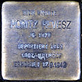 Stolperstein Köln, Moritz Revesz (Kerpener Straße 9).jpg 2,624 × 2,616; 1.06 MB
-
 Stolpersteine Köln, Kerpener Straße 9.jpg 3,296 × 2,152; 1,016 KB
-
 Stolpersteine Köln, Wohnhaus Kerpener Straße 9.jpg 4,312 × 3,592; 1.5 MB
.jpg)


.jpg)
.jpg)

