Category:Kerns - Kapelle St. Nikolaus
Jump to navigation
Jump to search
| Object location | | View all coordinates using: OpenStreetMap |
|---|
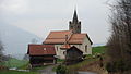
chapel building in St. Niklausen in the canton of Obwalden, Switzerland  .jpg) | |||||
| Upload media | |||||
| Instance of | |||||
|---|---|---|---|---|---|
| Part of | |||||
| Location | St. Niklausen, Kerns, Obwalden, Switzerland | ||||
| Street address |
| ||||
| Diocese | |||||
| Heritage designation | |||||
 | |||||
Media in category "Kerns - Kapelle St. Nikolaus"
The following 8 files are in this category, out of 8 total.
-
 Kapelle St Niklausen OW.jpg 1,465 × 1,187; 348 KB
-
 Kapelle St. Niklausen Kerns OW 1.jpg 6,048 × 4,024; 14 MB
-
 Kapelle St. Niklausen Kerns OW 2.jpg 6,048 × 4,024; 22.43 MB
-
 Kapelle St. Niklausen Kerns OW 3.jpg 2,048 × 1,536; 1.05 MB
-
 Kapelle St. Niklausen Kerns OW 4.jpg 2,048 × 1,536; 1.6 MB
-
 Kapelle St. Niklausen Kerns OW 5.jpg 2,048 × 1,536; 1.5 MB
-
 Kirche St. Niklausen.jpg 3,648 × 2,056; 3.16 MB
-
 Kirche St. Nikolausen (Innenansicht).jpg 3,648 × 2,056; 3.07 MB


