Category:Katholische Pfarrkirche, Riedau
Jump to navigation
Jump to search
| Object location | | View all coordinates using: OpenStreetMap |
|---|
| This category shows the protected monument with the number 60305 in Austria. (Commons, de, Wikidata) |
church building in Riedau, Austria   | |||||
| Upload media | |||||
| Instance of | |||||
|---|---|---|---|---|---|
| Named after | |||||
| Location | Riedau, Schärding District, Upper Austria, Austria | ||||
| Street address |
| ||||
| Heritage designation | |||||
 | |||||
Subcategories
This category has only the following subcategory.
I
Media in category "Katholische Pfarrkirche, Riedau"
The following 13 files are in this category, out of 13 total.
-
 Riedau Kirche 2.JPG 4,608 × 3,456; 3.01 MB
-
 Riedau Kirche 3.JPG 4,608 × 3,456; 3.64 MB
-
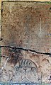 Riedau Pfarrkirche - Grabstein Knöring 1683.jpg 2,300 × 3,832; 2.67 MB
-
 Riedau Pfarrkirche - Portal 1.jpg 2,241 × 3,757; 1.7 MB
-
 Riedau Pfarrkirche - Portal 2.jpg 3,000 × 4,000; 5.76 MB
-
 Riedau Pfarrkirche - Portal 3.jpg 2,737 × 3,711; 1.45 MB
-
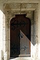 Riedau Pfarrkirche - Portal 4.jpg 2,322 × 3,435; 2 MB
-
 Riedau Pfarrkirche - Ölberg 1.jpg 4,000 × 3,000; 5.94 MB
-
 Riedau Pfarrkirche - Ölberg 2.jpg 4,000 × 3,000; 5.79 MB
-
 Riedau Pfarrkirche - Ölberg Gitter 1 Wappen.jpg 2,207 × 2,773; 1.51 MB
-
 Riedau Pfarrkirche - Ölberg Gitter 2 Wappen.jpg 2,646 × 2,666; 1.64 MB
-
 Riedau Pfarrkirche - Ölberg Gitter 3 Wappen.jpg 2,801 × 3,307; 1.65 MB
-
 Riedau Pfarrkirche - Ölberg Gitter 4 Wappen.jpg 4,000 × 3,000; 4.99 MB


