Category:Kapelle St. Jakob (Gasenried)
Jump to navigation
Jump to search
| Object location | | View all coordinates using: OpenStreetMap |
|---|
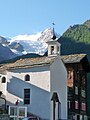
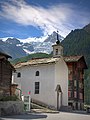
church building in Gasenried in the canton of Valais, Switzerland  | |||||
| Upload media | |||||
| Instance of | |||||
|---|---|---|---|---|---|
| Location | Gasenried, St. Niklaus, Visp District, Valais, Switzerland | ||||
| Street address |
| ||||
| Elevation above sea level |
| ||||
 | |||||
Media in category "Kapelle St. Jakob (Gasenried)"
The following 3 files are in this category, out of 3 total.
-
 Gasenried Kapelle Riedgletscher.jpg 4,000 × 3,000; 4.77 MB
-
 Gasenried.JPG 1,414 × 1,883; 448 KB
-
 Gasenried.jpg 960 × 1,280; 327 KB

