Category:Kühgundkopf
Jump to navigation
Jump to search
mountain in the Allgäu Alps at the border Bavaria / Tyrol  | |||||
| Upload media | |||||
| Instance of | |||||
|---|---|---|---|---|---|
| Made from material | |||||
| Location |
| ||||
| Mountain range | |||||
| Topographic prominence |
| ||||
| Topographic isolation |
| ||||
| Elevation above sea level |
| ||||
 | |||||
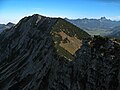
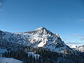
Deutsch: Der Kühgundkopf (auch Wannenjoch) ist ein 1907 Meter hoher Berg in den Allgäuer Alpen, über den die Grenze zwischen Deutschland (Bayern) und Österreich (Tirol) verläuft.
English: The Kühgundkopf (also Wannenjoch) (1907 m) is a mountain in the Allgäu Alps, situated on the border between Germany (Bavaria) and Austria (Tyrol).
Media in category "Kühgundkopf"
The following 34 files are in this category, out of 34 total.
-
 20210901 Kühgundkopf - 054.jpg 6,024 × 4,024; 8.61 MB
-
 AUT – Tirol – Bezirk Reutte — Gemeinde Schattwald — Kühgundkopf (s' Wannenjochkino) 2020.jpg 7,296 × 5,472; 8.54 MB
-
 AUT — Tirol — Bezirk Reutte — Schattwald — Schattwald 32 (Bergstation Jochstadl) 2020.jpg 3,409 × 2,309; 2.77 MB
-
 Grän06-20.JPG 2,048 × 1,536; 1.62 MB
-
 Hirschberg Tannheimer Berge.JPG 3,264 × 2,448; 4.67 MB
-
 Iseler Klettersteig Kühgundkopf.jpg 3,264 × 2,448; 3.88 MB
-
 Iseler Nordflanke.JPG 3,264 × 2,448; 4.41 MB
-
 Iselerkar mit Kühgund.jpg 640 × 480; 49 KB
-
 Jochpass Passhöhe 1178m.JPG 2,304 × 1,728; 1.19 MB
-
 Kuehgundspitze.JPG 3,264 × 2,448; 4.25 MB
-
 Kühgrundkopf und Wannenjoch.jpg 4,000 × 3,000; 5 MB
-
 Kühgund1.JPG 1,536 × 2,048; 899 KB
-
 Kühgundkopf Iseler.jpg 3,264 × 2,448; 2.71 MB
-
 Kühgundkopf Northeastridge Schönkahler Reuterwanne Edelsberg.JPG 2,448 × 3,264; 3.61 MB
-
 Kühgundkopf Schönkahler.JPG 3,264 × 2,448; 3.91 MB
-
 Kühgundkopf Summit.JPG 3,264 × 2,448; 3.09 MB
-
 Kühgundkopf, 1.907 m.jpg 4,000 × 3,000; 4.69 MB
-
 Kühgundkopf, Allgäuer Alpen (2022-07-13), by Klugschnacker in Wikipedia.jpg 4,000 × 2,250; 3.92 MB
-
 Kühgundkopf-1.jpg 3,264 × 2,176; 1.61 MB
-
 Kühgundkopf.JPG 3,264 × 2,448; 2.85 MB
-
 Kühgundspitze-1.jpg 2,481 × 1,654; 1.55 MB
-
 Kühgundspitze-2.jpg 3,264 × 2,176; 1.65 MB
-
 Kühgundspitze-3.jpg 2,176 × 2,901; 1.1 MB
-
 Lumberger Grat and Seichenkopf.JPG 3,840 × 2,160; 2.28 MB
-
 OABadHindelangOberjoch04.jpg 4,272 × 2,848; 2.69 MB
-
 Oberallgäu GO-2.jpg 2,592 × 1,944; 1.05 MB
-
 Oberjoch Moorbad Baum.jpg 1,920 × 2,560; 1.08 MB
-
 Oberjoch, Bad Hindelang, Deutschland (Unsplash).jpg 15,240 × 5,080; 37.84 MB
-
 Schattwald - panoramio (1).jpg 2,816 × 2,120; 1.39 MB
-
 Schattwald - panoramio.jpg 2,816 × 2,120; 1.48 MB
-
 Seichenkopf.JPG 3,264 × 2,448; 3.59 MB
-
 St. Leonhard in Kienzen (Pestkapelle)011.JPG 2,048 × 1,536; 522 KB
-
 Wilhelm Walther, Nachbauer, 1-026-7475.tif 6,024 × 4,022; 46.23 MB
-
 Wilhelm Walther, Oberjoch, 1-033-034-7495.tif 6,024 × 4,022; 46.23 MB

_2020.jpg)
_2020.jpg)


,_by_Klugschnacker_in_Wikipedia.jpg)


.jpg)


011.JPG)
.jpg)