Category:Jubilee River
Jump to navigation
Jump to search
Deutsch: Der Jubilee River ist ein 11,6 km langer Kanal in Südengland, der in den späten 1990ern und frühen 2000ern gebaut wurde, um Überflutungen bestimmter Bereiche bei Hochwasser der Themse zu verhindern. Der Kanal schützt unter anderem Maidenhead, Windsor und Eton in den Grafschaften Berkshire und Buckinghamshire.
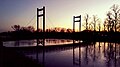
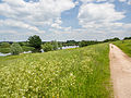
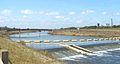
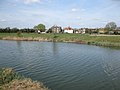
English: The Jubilee River is a hydraulic channel in southern England. It is 11.6 km (7.2 mi) in length and is on average 45 metres (148 ft) wide. It was constructed in the late 1990s and early 2000s to take overflow from the River Thames and so alleviate flooding to areas in and around the towns of Maidenhead, Windsor, and Eton in the counties of Berkshire and Buckinghamshire. It achieves this by allowing excess water to be taken via the east bank of the Thames upstream of Boulter's Lock near Maidenhead and returned via the north-east bank downstream of Eton.
Norsk bokmål: Jubilee River er en kunstig elv som ble anlagt i 1990-årene for å lede flomvann fra Themsen rundt Maidenhead, Windsor og Eton. Den er menneskeskapt, men ble laget slik at den ser ut som og oppfører seg som en naturlig elv. Den kan klassifiseres som en kanal, men regnes normalt som en elv.
artificial anabranch, in most flow as a flood relief channel, of the (river) Thames  | |||||
| Upload media | |||||
| Instance of | |||||
|---|---|---|---|---|---|
| Location |
| ||||
 | |||||
Media in category "Jubilee River"
The following 91 files are in this category, out of 91 total.
-

-
 Bee beside flower (14397736543).jpg 4,608 × 3,456; 6 MB
-
 Bee on dog rose (14397823753).jpg 4,608 × 3,456; 7.75 MB
-
 Bee on flower (14191145767).jpg 4,608 × 3,456; 6.14 MB
-
 Bee on flower (14374239081).jpg 4,608 × 3,456; 6.01 MB
-
 Bee on flower (14376627624).jpg 4,608 × 3,456; 6.33 MB
-
 Black potts viaduct.jpg 384 × 288; 78 KB
-
 Bridge over marsh (14397794703).jpg 4,608 × 3,456; 12.7 MB
-
 Canada goose, spreading its wings (14191178217).jpg 4,608 × 3,456; 6.97 MB
-
 Cormorant (14191003008).jpg 4,608 × 3,456; 7.77 MB
-
 Cormorant (14191064750).jpg 4,608 × 3,456; 7.86 MB
-
 Cormorant (14376672254).jpg 4,608 × 3,456; 7.49 MB
-
 Cormorant and tern on bouys (14161478159).jpg 4,608 × 3,456; 8.3 MB
-
 Cormorant on bouy (14161475519).jpg 4,608 × 3,456; 8.18 MB
-
 Cormorant on bouy (14348145305).jpg 4,608 × 3,456; 7.95 MB
-
 Cyclists (14161483929).jpg 3,456 × 4,608; 11.32 MB
-
 Dandelion (14368895004).jpg 4,608 × 3,456; 7.13 MB
-
 Dog roses (14397820153).jpg 4,608 × 3,456; 7.88 MB
-
 Dorney Common (14369472111).jpg 4,608 × 3,456; 12.23 MB
-
 Dorney Wetlands (34674529531).jpg 4,032 × 3,024; 5.11 MB
-
 Ducks perching upon hide (14190971489).jpg 4,608 × 3,456; 7.5 MB
-
 Eton Bridge, Jubilee River (11858836184).jpg 4,128 × 2,322; 4.68 MB
-
 Evening Walk (24337852801).jpg 3,776 × 2,520; 4.14 MB
-
 Flies by reed and goose (14190973729).jpg 4,608 × 3,456; 6.71 MB
-
 Flower buds (14191165667).jpg 4,608 × 3,456; 5.93 MB
-
 Footbridge over Jubilee River - geograph.org.uk - 25622.jpg 640 × 480; 101 KB
-
 Geese with goslings (14376700054).jpg 4,608 × 3,456; 10.76 MB
-
 Great crested grebe (14186167489).jpg 4,608 × 3,456; 7.52 MB
-
 Great crested grebe (14354516416).jpg 4,608 × 3,456; 7.52 MB
-
 Great crested grebe (14372805545).jpg 4,608 × 3,456; 7.33 MB
-
 Great crested grebe (14392979133).jpg 4,608 × 3,456; 7.54 MB
-
 Great crested grebe (14397732763).jpg 4,608 × 3,456; 7.71 MB
-
 Gull on bouy (14161487218).jpg 4,608 × 3,456; 6.93 MB
-
 Heron (14354575826).jpg 4,608 × 3,456; 8.56 MB
-
 Jubilee River (14325015446).jpg 4,608 × 3,456; 8.85 MB
-
 Jubilee River (14325017216).jpg 4,608 × 3,456; 11.85 MB
-
 Jubilee River (14346559142).jpg 4,608 × 3,456; 7.61 MB
-
 Jubilee River (14347310844).jpg 4,608 × 3,456; 12.26 MB
-
 Jubilee River (14375658003).jpg 4,608 × 3,456; 10.45 MB
-
 Jubilee River (15819684360).jpg 3,776 × 2,520; 2.03 MB
-
 Jubilee River (15819686900).jpg 3,776 × 2,520; 2.64 MB
-
 Jubilee River (15820943899).jpg 3,776 × 2,520; 2.47 MB
-
 Jubilee River (2484598918).jpg 1,600 × 1,200; 197 KB
-
 Jubilee River (29036595454).jpg 3,072 × 1,728; 3 MB
-
 Jubilee River (29298367100).jpg 3,072 × 1,728; 988 KB
-
 Jubilee River (29478713242).jpg 3,072 × 1,728; 2.48 MB
-
 Jubilee River (29478715342).jpg 7,702 × 1,563; 4.14 MB
-
 Jubilee River (29588556145).jpg 3,072 × 1,728; 1.54 MB
-
 Jubilee River (30030032863).jpg 4,032 × 3,024; 3.5 MB
-
 Jubilee River (30030033663).jpg 2,269 × 1,792; 806 KB
-
 Jubilee River (30605505861).jpg 3,776 × 2,520; 2.75 MB
-
 Jubilee River (31653327873).jpg 4,032 × 3,024; 6.94 MB
-
 Jubilee River (32784691702).jpg 4,032 × 3,024; 5.57 MB
-
 Jubilee River (33075378494).jpg 4,032 × 3,024; 4.73 MB
-
 Jubilee River (33075381104).jpg 4,032 × 3,024; 4.79 MB
-
 Jubilee River (33762134632).jpg 4,032 × 3,024; 4.36 MB
-
 Jubilee River (36843083196).jpg 4,032 × 3,024; 4.56 MB
-
 Jubilee River (42905943130).jpg 4,032 × 3,024; 3.63 MB
-
 Jubilee River above Marsh Lane weir - geograph.org.uk - 720551.jpg 640 × 480; 156 KB
-
 Jubilee River at Dorney - geograph.org.uk - 1117466.jpg 640 × 480; 44 KB
-
 Jubilee river vista (14354560236).jpg 4,608 × 3,456; 8.9 MB
-
 Jubilee River, Chalvey Bridge - geograph.org.uk - 1115256.jpg 640 × 474; 77 KB
-

-
 Jubilee River, M4 motorway bridge - geograph.org.uk - 71693.jpg 640 × 425; 100 KB
-
 Jubilee River, Maidenhead - geograph.org.uk - 71700.jpg 640 × 425; 74 KB
-
 Jubilee River, Marsh Lane Weir - geograph.org.uk - 71688.jpg 640 × 425; 100 KB
-
 Jubilee River, near Slough - geograph.org.uk - 25624.jpg 640 × 480; 90 KB
-
 Jubilee River, Sunset at Dorney - geograph.org.uk - 1117449.jpg 640 × 480; 37 KB
-
 Jubilee weir.jpg 447 × 237; 47 KB
-
 Marsh Lane houses from Jubilee River - geograph.org.uk - 720553.jpg 640 × 480; 66 KB
-
 National cycle network route 61 - geograph.org.uk - 1802267.jpg 2,272 × 1,704; 2.43 MB
-
 Nesting swan (14161485708).jpg 4,608 × 3,456; 10.86 MB
-
 Ragwort (14186165579).jpg 4,608 × 3,456; 9.01 MB
-
 Ragwort (14375659423).jpg 4,608 × 3,456; 8.72 MB
-
 Reed (14354490496).jpg 4,608 × 3,456; 7.71 MB
-
 Reed (14376132652).jpg 4,608 × 3,456; 6.19 MB
-

-
 Small purple flower (14354545246).jpg 4,608 × 3,456; 7.15 MB
-
 Sunset (29259917838).jpg 4,032 × 3,024; 2.27 MB
-
 Swan and cygnets (14191017719).jpg 4,608 × 3,456; 10.27 MB
-
 Taplow Riverside (29411233088).jpg 4,032 × 3,024; 4.03 MB
-
 Taplow Riverside (32784689602).jpg 4,032 × 3,024; 3.17 MB
-
 Taplow Riverside (39350352364).jpg 3,776 × 2,520; 2.86 MB
-
 Tern (in flight) (14376721104).jpg 4,608 × 3,456; 8.67 MB
-
 Tern and heron (14397836403).jpg 4,608 × 3,456; 10.5 MB
-
 Tern on bouy (14161491498).jpg 4,608 × 3,456; 8.12 MB
-
 Upstream from Marsh Lane Weir - geograph.org.uk - 886887.jpg 640 × 480; 44 KB
-
 View of Lake End from the Jubilee River bridge - geograph.org.uk - 1802684.jpg 2,272 × 1,704; 1.82 MB
-
 View of Windsor Castle (14186183848).jpg 4,608 × 3,456; 7.7 MB
-
 View of Windsor Castle (14371331402).jpg 4,608 × 3,456; 8.78 MB
-
 Winding path (14354572446).jpg 4,608 × 3,456; 10.98 MB

.jpg)
.jpg)
.jpg)
.jpg)
.jpg)

.jpg)
.jpg)
.jpg)
.jpg)
.jpg)
.jpg)
.jpg)
.jpg)
.jpg)
.jpg)
.jpg)
.jpg)
.jpg)
.jpg)
.jpg)
.jpg)
.jpg)
.jpg)

.jpg)
.jpg)
.jpg)
.jpg)
.jpg)
.jpg)
.jpg)
.jpg)
.jpg)
.jpg)
.jpg)
.jpg)
.jpg)
.jpg)
.jpg)
.jpg)
.jpg)
.jpg)
.jpg)
.jpg)
.jpg)
.jpg)
.jpg)
.jpg)
.jpg)
.jpg)
.jpg)
.jpg)
.jpg)
.jpg)
.jpg)


.jpg)


.jpg)
.jpg)
.jpg)
.jpg)
.jpg)

.jpg)
.jpg)
.jpg)
.jpg)
.jpg)
.jpg)
_(14376721104).jpg)
.jpg)
.jpg)


.jpg)
.jpg)
.jpg)
.jpg)