Category:John Ogilby (1675) Britannia Atlas
Jump to navigation
Jump to search
John Ogilby's Britannia atlas of 1675 set the standard for the road maps that followed. One hundred strip road maps are shown, accompanied by a double-sided page of text giving additional advice for the map's use, all at a consistent scale of one inch to the mile (1/63360).
See John Ogilby for a full list of plates.
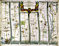
work by John Ogilby published in 1675; the first road atlas of England and Wales .jpg) The Road from London to the City of Bristol, from Britannia, 1675 | |||||
| Upload media | |||||
| Instance of |
| ||||
|---|---|---|---|---|---|
| Genre |
| ||||
| Author | |||||
| Language of work or name | |||||
| Publication date |
| ||||
| |||||
Media in category "John Ogilby (1675) Britannia Atlas"
The following 10 files are in this category, out of 10 total.
-

-

-
 Bodleian Libraries, The Road from London to Aberistwyth.jpg 672 × 1,000; 161 KB
-
 Bodleian Libraries, The Road from Oxford to Coventry.jpg 672 × 1,000; 160 KB
-
 Britannia Atlas Newmarket to Wells and Bury Edmunds 1675.jpg 2,360 × 1,809; 573 KB
-
 John Ogilby - The Road from London to the City of Bristol (1675).jpg 3,372 × 2,424; 914 KB
-
 London to Harwich map by John Ogilby.jpg 1,600 × 1,248; 675 KB
-

-
 Ogilby - The Road From LONDON to the LANDS END (1675).jpg 2,687 × 1,941; 1.29 MB
-

.jpg)
.jpg)


.jpg)
.jpg)
