Category:Johannes de Doperkerk (Kaatsheuvel)
Jump to navigation
Jump to search
| Object location | | View all coordinates using: OpenStreetMap |
|---|
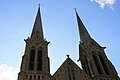
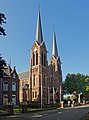
Nederlands: Afbeeldingen van de Johannes de Doperkerk, Hoofdstraat 36, 5171 DD Kaatsheuvel. Gelegen in Kaatsheuvel behorende tot de gemeente Loon op Zand in de provincie Noord-Brabant in het zuiden van Nederland. Het is een rijksmonument
|
This is a category about rijksmonument number 525704
|
church building in Loon op Zand, Netherlands  | |||||
| Upload media | |||||
| Instance of | |||||
|---|---|---|---|---|---|
| Part of | |||||
| Location | Kaatsheuvel, Loon op Zand, North Brabant, Netherlands | ||||
| Street address |
| ||||
| Located on street |
| ||||
| Architect |
| ||||
| Heritage designation |
| ||||
| Inception |
| ||||
| Religion or worldview | |||||
 | |||||
Subcategories
This category has only the following subcategory.
Media in category "Johannes de Doperkerk (Kaatsheuvel)"
The following 8 files are in this category, out of 8 total.
-
 525704 Johannes de Doperkerk kaatsheuvel.jpg 5,136 × 4,339; 18.85 MB
-
 525704 R.K. Kerk van de H. Johannes de Doper.jpg 3,000 × 2,325; 6.5 MB
-
 Johannes de Doperkerk van de zijkant bezien.jpg 3,872 × 2,592; 7.35 MB
-
 Johannes den Dooper kerk Kaatsheuvel.jpg 2,848 × 4,288; 4.17 MB
-
 Kaatsheuvel - Hoofdstraat 30 - Johannes de Doperkerk.jpg 800 × 533; 164 KB
-
 Kaatsheuvel - Johannes de Doperkerk.jpg 740 × 1,000; 669 KB
-
 Kaatsheuvel Sint Jan.jpg 2,250 × 2,967; 1.65 MB
-
 Kaatsheuvel St. Johannes de Doperkerk (foto 03-06-2017) (f2).jpg 4,000 × 6,000; 6.43 MB


_(f2).jpg)