Category:JPEG2000 format all 67 maps from Indian Land Cessions in the United States (1899)
SOURCE: https://www.loc.gov/item/13023487/
JPEG 2000 versions were not available for three maps; next largest JPEG sizes were uploaded.

|
This image is available from the United States Library of Congress's Geography & Map Division
under the digital ID g3701em.gct00002. This tag does not indicate the copyright status of the attached work. A normal copyright tag is still required. See Commons:Licensing.
|
Title
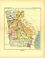
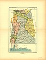
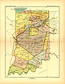
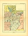
Indian land cessions in the United States, Names
Royce, Charles C., 1845-1923 Thomas, Cyrus, 1825-1910 Headings
- Indian land transfers--United States - Indians of North America--Government relations - United States Notes
- United States Serial Set Number 4015 contains the second part of the two-part Eighteenth Annual Report of the Bureau of American Ethnology to the Secretary of the Smithsonian Institution, 1896-1897. (Part one is printed in United States Serial Set Number 4014.) Part two, which was also printed as House Document No. 736 of the U.S. Serial Set, 56th Congress, 1st Session, features sixty-seven maps and two tables compiled by Charles C. Royce, with an introductory essay by Cyrus Thomas. The tables are entitled: Schedule of Treaties and Acts of Congress Authorizing Allotments of Lands in Severalty and Schedule of Indian Land Cessions. The Schedule of Indian Land Cessions subtitle notes that it "indicates the number and location of each cession by or reservation for the Indian tribes from the organization of the Federal Government to and including 1894, together with descriptions of the tracts so ceded or reserved, the date of the treaty, law or executive order governing the same, the name of the tribe or tribes affected thereby, and historical data and references bearing thereon." - Available also through the Library of Congress Web site as a raster image. - Copy 3 NOS 10/7/93 Medium
pages 521-997 ; 30 cm. Call Number/Physical Location
KIE610 .R69 1899 E93 .R885 GN2 .U5 G1201.G6 R7 1899 HD231 .R7 1899 Another issue (56th Cong., 1st sess. House. Doc. 736. Source Collection
Smithsonian Institution. Bureau of American Ethnology. Eighteenth annual report ... 1896-'97. pt. 2, p. 521-997, 67 maps (part double). 30 cm. Repository
Library of Congress Geography and Map Division Washington, D.C. 20540-4650 USA dcu Digital Id
http://hdl.loc.gov/loc.gmd/g3701em.gct00002 https://hdl.loc.gov/loc.law/llscd.llss4014 https://hdl.loc.gov/loc.law/llscd.llss4015 Library of Congress Control Number
13023487 Online Format
online text image pdf LCCN Permalink
https://lccn.loc.gov/13023487 Additional Metadata Formats
MARCXML Record MODS Record Dublin Core Record IIIF Presentation Manifest
Manifest (JSON/LD)
Media in category "JPEG2000 format all 67 maps from Indian Land Cessions in the United States (1899)"
The following 67 files are in this category, out of 67 total.
-
 Map from Indian land cessions in the United States by Charles C. Royce 01.jpg 3,297 × 4,256; 4.44 MB
-
 Map from Indian land cessions in the United States by Charles C. Royce 02.jpg 4,256 × 3,297; 4.08 MB
-
 Map from Indian land cessions in the United States by Charles C. Royce 03.jpg 4,256 × 3,297; 4.24 MB
-
 Map from Indian land cessions in the United States by Charles C. Royce 04.jpg 4,256 × 3,297; 4.24 MB
-
 Map from Indian land cessions in the United States by Charles C. Royce 05.jpg 4,256 × 3,297; 4.59 MB
-
 Map from Indian land cessions in the United States by Charles C. Royce 06.jpg 3,297 × 4,256; 4.49 MB
-
 Map from Indian land cessions in the United States by Charles C. Royce 07.jpg 4,256 × 3,297; 4.34 MB
-
 Map from Indian land cessions in the United States by Charles C. Royce 08.jpg 4,256 × 3,297; 5.93 MB
-
 Map from Indian land cessions in the United States by Charles C. Royce 09.jpg 3,297 × 4,256; 5.36 MB
-
 Map from Indian land cessions in the United States by Charles C. Royce 10.jpg 3,297 × 4,256; 4.31 MB
-
 Map from Indian land cessions in the United States by Charles C. Royce 11.jpg 2,131 × 3,428; 2.9 MB
-
 Map from Indian land cessions in the United States by Charles C. Royce 12.jpg 3,297 × 4,256; 4.63 MB
-
 Map from Indian land cessions in the United States by Charles C. Royce 13.jpg 3,297 × 4,256; 4.13 MB
-
 Map from Indian land cessions in the United States by Charles C. Royce 14.jpg 4,256 × 3,297; 3.72 MB
-
 Map from Indian land cessions in the United States by Charles C. Royce 15.jpg 4,256 × 3,297; 4.48 MB
-
 Map from Indian land cessions in the United States by Charles C. Royce 16.jpg 4,256 × 3,297; 5.04 MB
-
 Map from Indian land cessions in the United States by Charles C. Royce 17.jpg 3,297 × 4,256; 4.05 MB
-
 Map from Indian land cessions in the United States by Charles C. Royce 18.jpg 3,297 × 4,256; 4.06 MB
-
 Map from Indian land cessions in the United States by Charles C. Royce 19.jpg 3,297 × 4,256; 4.37 MB
-
 Map from Indian land cessions in the United States by Charles C. Royce 20.jpg 825 × 1,064; 160 KB
-
 Map from Indian land cessions in the United States by Charles C. Royce 21.jpg 3,297 × 4,256; 4.55 MB
-
 Map from Indian land cessions in the United States by Charles C. Royce 22.jpg 4,256 × 3,297; 4.04 MB
-
 Map from Indian land cessions in the United States by Charles C. Royce 23.jpg 4,256 × 3,297; 4.09 MB
-
 Map from Indian land cessions in the United States by Charles C. Royce 24.jpg 4,256 × 3,297; 4.62 MB
-
 Map from Indian land cessions in the United States by Charles C. Royce 25.jpg 3,283 × 2,141; 1.8 MB
-
 Map from Indian land cessions in the United States by Charles C. Royce 26.jpg 3,297 × 4,256; 4.74 MB
-
 Map from Indian land cessions in the United States by Charles C. Royce 27.jpg 825 × 1,064; 219 KB
-
 Map from Indian land cessions in the United States by Charles C. Royce 28.jpg 3,297 × 4,256; 4.14 MB
-
 Map from Indian land cessions in the United States by Charles C. Royce 29.jpg 3,297 × 4,256; 4.34 MB
-
 Map from Indian land cessions in the United States by Charles C. Royce 30.jpg 4,256 × 3,297; 4.92 MB
-
 Map from Indian land cessions in the United States by Charles C. Royce 31.jpg 3,297 × 4,256; 4.4 MB
-
 Map from Indian land cessions in the United States by Charles C. Royce 32.jpg 3,297 × 4,256; 4.76 MB
-
 Map from Indian land cessions in the United States by Charles C. Royce 33.jpg 3,283 × 2,141; 2.04 MB
-
 Map from Indian land cessions in the United States by Charles C. Royce 34.jpg 4,256 × 3,297; 4.47 MB
-
 Map from Indian land cessions in the United States by Charles C. Royce 35.jpg 4,256 × 3,297; 4.61 MB
-
 Map from Indian land cessions in the United States by Charles C. Royce 36.jpg 3,297 × 4,256; 4.33 MB
-
 Map from Indian land cessions in the United States by Charles C. Royce 37.jpg 1,064 × 825; 151 KB
-
 Map from Indian land cessions in the United States by Charles C. Royce 38.jpg 4,256 × 3,297; 4.59 MB
-
 Map from Indian land cessions in the United States by Charles C. Royce 39.jpg 3,297 × 4,256; 4.7 MB
-
 Map from Indian land cessions in the United States by Charles C. Royce 40.jpg 3,297 × 4,256; 4.28 MB
-
 Map from Indian land cessions in the United States by Charles C. Royce 41.jpg 3,283 × 2,141; 1.84 MB
-
 Map from Indian land cessions in the United States by Charles C. Royce 42.jpg 3,297 × 4,256; 4.96 MB
-
 Map from Indian land cessions in the United States by Charles C. Royce 43.jpg 4,256 × 3,297; 4.46 MB
-
 Map from Indian land cessions in the United States by Charles C. Royce 44.jpg 2,464 × 3,339; 2.35 MB
-
 Map from Indian land cessions in the United States by Charles C. Royce 45.jpg 3,297 × 4,256; 4.73 MB
-
 Map from Indian land cessions in the United States by Charles C. Royce 46.jpg 3,297 × 4,256; 4.04 MB
-
 Map from Indian land cessions in the United States by Charles C. Royce 47.jpg 4,256 × 3,297; 4.26 MB
-
 Map from Indian land cessions in the United States by Charles C. Royce 48.jpg 3,283 × 2,141; 2.18 MB
-
 Map from Indian land cessions in the United States by Charles C. Royce 49.jpg 3,297 × 4,256; 4.57 MB
-
 Map from Indian land cessions in the United States by Charles C. Royce 50.jpg 4,256 × 3,297; 4.62 MB
-
 Map from Indian land cessions in the United States by Charles C. Royce 51.jpg 4,256 × 3,297; 4.81 MB
-
 Map from Indian land cessions in the United States by Charles C. Royce 52.jpg 3,283 × 2,141; 2.45 MB
-
 Map from Indian land cessions in the United States by Charles C. Royce 53.jpg 3,297 × 4,256; 5 MB
-
 Map from Indian land cessions in the United States by Charles C. Royce 54.jpg 3,297 × 4,256; 4.49 MB
-
 Map from Indian land cessions in the United States by Charles C. Royce 55.jpg 3,297 × 4,256; 5.03 MB
-
 Map from Indian land cessions in the United States by Charles C. Royce 56.jpg 4,256 × 3,297; 4.42 MB
-
 Map from Indian land cessions in the United States by Charles C. Royce 57.jpg 3,297 × 4,256; 4.65 MB
-
 Map from Indian land cessions in the United States by Charles C. Royce 58.jpg 4,256 × 3,297; 4.94 MB
-
 Map from Indian land cessions in the United States by Charles C. Royce 60.jpg 4,256 × 3,297; 4.18 MB
-
 Map from Indian land cessions in the United States by Charles C. Royce 61.jpg 4,256 × 3,297; 4.91 MB
-
 Map from Indian land cessions in the United States by Charles C. Royce 62.jpg 3,297 × 4,256; 3.95 MB
-
 Map from Indian land cessions in the United States by Charles C. Royce 63.jpg 4,256 × 3,297; 4.43 MB
-

-
 Map from Indian land cessions in the United States by Charles C. Royce 65.jpg 4,256 × 3,297; 5.52 MB
-
 Map from Indian land cessions in the United States by Charles C. Royce 66.jpg 4,256 × 3,297; 5.33 MB
-
 Map from Indian land cessions in the United States by Charles C. Royce 67.jpg 3,297 × 4,256; 3.95 MB
-


