Category:Interstate 80 in Utah
Jump to navigation
Jump to search
States of the United States: California · Illinois · Indiana · Iowa · Nebraska · Nevada · New Jersey · Ohio · Pennsylvania · Utah · Wyoming
section of Interstate Highway in Utah, United States  .svg) _map.svg) | |||||
| Upload media | |||||
| Instance of | |||||
|---|---|---|---|---|---|
| Part of | |||||
| Location |
| ||||
| Transport network | |||||
| Connects with | |||||
| Owned by | |||||
| Maintained by | |||||
| Inception |
| ||||
| Length |
| ||||
| Terminus | |||||
| Partially coincident with | |||||
 | |||||
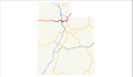
English: Media related to Interstate 80 in Utah (Dwight D. Eisenhower Highway and Purple Heart Trail), a major east-west Interstate highway in northern Utah, United States, that connects Interstate 80 in Nevada (towards Reno) in Wendover with Interstate 80 and U.S. Route 189 at the Wyoming border (towards Cheyenne), southwest of Evanston, Wyoming, via Salt Lake City. Interstate 80 a brief concurrency with Interstate 15 in Salt Lake County. Also the eastern end (from Silver Summit) runs concurrent with U.S. Route 189.
From 1962 to 1977, the new Interstate 80 in Utah was officially designated as State Route 2 by the Utah State Legislature. Since 1977, it has been officially designated as State Route 80. From 1910 to 1962 the highways along this same corridor had been designated as State Route 4.
From 1962 to 1977, the new Interstate 80 in Utah was officially designated as State Route 2 by the Utah State Legislature. Since 1977, it has been officially designated as State Route 80. From 1910 to 1962 the highways along this same corridor had been designated as State Route 4.
Subcategories
This category has the following 6 subcategories, out of 6 total.
*
1
R
Media in category "Interstate 80 in Utah"
The following 10 files are in this category, out of 10 total.
-
 I-80 (UT) map 2.svg 1,180 × 688; 63 KB
-
 I-80 (UT) map.svg 1,475 × 860; 344 KB
-
 I-80 (UT) Metric.svg 601 × 601; 17 KB
-
 I-80 (UT).svg 601 × 601; 17 KB
-
 Utah 2.svg 600 × 600; 11 KB
-
 Utah 80.svg 600 × 600; 12 KB
-
 Utah SR 2.svg 385 × 385; 7 KB
-
 Utah SR 80.svg 385 × 385; 10 KB
-
 WCNF Wilderness Map.jpg 700 × 513; 91 KB
-
 Wendover locator map.png 500 × 410; 803 KB
_map_2.svg)
_Metric.svg)


