Category:Insolation maps of Africa
Jump to navigation
Jump to search
Subcategories
This category has the following 54 subcategories, out of 54 total.
A
- Insolation maps of Algeria (8 F)
- Insolation maps of Angola (6 F)
B
- Insolation maps of Benin (6 F)
- Insolation maps of Botswana (3 F)
- Insolation maps of Burundi (6 F)
C
- Insolation maps of Cameroon (6 F)
- Insolation maps of Chad (6 F)
D
- Insolation maps of Djibouti (6 F)
E
- Insolation maps of Egypt (4 F)
- Insolation maps of Eritrea (3 F)
- Insolation maps of Eswatini (3 F)
- Insolation maps of Ethiopia (4 F)
G
- Insolation maps of Gabon (6 F)
- Insolation maps of Ghana (3 F)
- Insolation maps of Guinea (6 F)
K
- Insolation maps of Kenya (3 F)
L
- Insolation maps of Lesotho (3 F)
- Insolation maps of Liberia (3 F)
- Insolation maps of Libya (3 F)
M
- Insolation maps of Malawi (3 F)
- Insolation maps of Mali (6 F)
- Insolation maps of Mauritius (7 F)
- Insolation maps of Morocco (8 F)
N
- Insolation maps of Namibia (3 F)
- Insolation maps of Niger (6 F)
- Insolation maps of Nigeria (4 F)
R
- Insolation maps of Rwanda (3 F)
- Insolation maps of Réunion (3 F)
S
- Insolation maps of Senegal (6 F)
- Insolation maps of Somalia (4 F)
- Insolation maps of Sudan (3 F)
T
- Insolation maps of Tanzania (3 F)
- Insolation maps of Togo (6 F)
- Insolation maps of Tunisia (6 F)
U
- Insolation maps of Uganda (3 F)
Z
- Insolation maps of Zambia (3 F)
- Insolation maps of Zimbabwe (3 F)
Media in category "Insolation maps of Africa"
The following 19 files are in this category, out of 19 total.
-
 Africa 4-gs13.png 1,040 × 1,000; 398 KB
-
 SolarGIS-Solar-map-Africa-and-Middle-East-de.png 850 × 850; 663 KB
-
 SolarGIS-Solar-map-Africa-and-Middle-East-en.png 850 × 850; 561 KB
-
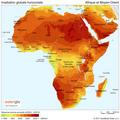 SolarGIS-Solar-map-Africa-and-Middle-East-fr.png 850 × 850; 664 KB
-
 SolarGIS-Solar-map-Africa-and-Middle-East-it.png 850 × 850; 666 KB
-

-
 Middle-East-and-North-Africa GHI mid-size-map 220x119mm-300dpi v20170928.png 2,598 × 1,411; 2.84 MB
-

-

-
 NREL-africa-glo.jpg 1,719 × 1,327; 411 KB
-
 PVGIS Africa SolarPotential img v2.png 1,719 × 1,344; 1.73 MB
-
 PVGIS Africa SolarPotential.bigopti.png 3,399 × 3,677; 9.02 MB
-
 PVGIS Mediterranean globrad opt angle.png 3,507 × 2,481; 4.54 MB
-
 Solar-Atlas-Med csp-gross.jpg 6,835 × 3,366; 3.83 MB
-
 SolarGIS-Solar-map-Africa-and-Middle-East-ar.png 850 × 850; 661 KB
-
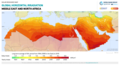
 Sub Saharan Africa GHI Solar-resource-map GlobalSolarAtlas World-Bank-Esmap-Solargis.png 1,842 × 2,275; 2.99 MB
-
 Sub-Saharan-Africa DNI Solar-resource-map GlobalSolarAtlas World-Bank-Esmap-Solargis.png 1,842 × 2,275; 2.18 MB
-
 Sub-Saharan-Africa GHI SOLARGIS.png 1,842 × 2,275; 2.21 MB
-


