Category:Images by Mike Quinn
Jump to navigation
Jump to search

Media in category "Images by Mike Quinn"
The following 200 files are in this category, out of 8,063 total.
(previous page) (next page)-

-

-

-

-
-

-

-

-

-
-

-
-

-

-

-

-
-

-

-
-

-
-

-
 "Blue Plaque" re Frankie Howerd OBE - geograph.org.uk - 849780.jpg 640 × 480; 92 KB
-

-
 "Camden Lock" railway bridge - geograph.org.uk - 1033730.jpg 640 × 480; 75 KB
-
 "Crossroads" of tracks on Howden Rigg - geograph.org.uk - 451210.jpg 640 × 480; 83 KB
-
-
 "Hush" and pastures near High Shield - geograph.org.uk - 720740.jpg 640 × 480; 85 KB
-
 "Hush" near West End (2) - geograph.org.uk - 720717.jpg 640 × 480; 107 KB
-
 "Hush" near West End (3) - geograph.org.uk - 720739.jpg 640 × 480; 124 KB
-
 "Hush" near West End - geograph.org.uk - 720704.jpg 640 × 480; 105 KB
-
 "Inkpot" octagonal lodge - geograph.org.uk - 1000879.jpg 640 × 480; 105 KB
-
 "Tanks" - geograph.org.uk - 830967.jpg 640 × 480; 65 KB
-

-

-
-
 (A very small part of) Hadrian's Wall - geograph.org.uk - 837908.jpg 640 × 480; 91 KB
-
 (All that remains of) Milecastle 33 - geograph.org.uk - 592666.jpg 640 × 480; 101 KB
-
 (Alleged) ford over the West Allen - geograph.org.uk - 413290.jpg 640 × 480; 142 KB
-
 (And another) boggy bit - geograph.org.uk - 392366.jpg 640 × 480; 112 KB
-
 (And another) old mine shaft - geograph.org.uk - 720656.jpg 640 × 480; 91 KB
-

-

-
 (Another) boggy bit - geograph.org.uk - 391125.jpg 640 × 480; 121 KB
-
 (Another) bracket fungus - geograph.org.uk - 844690.jpg 640 × 480; 121 KB
-

-
 (Another) footbridge over Catton Burn - geograph.org.uk - 635948.jpg 640 × 480; 152 KB
-
 (Another) footbridge over Halgut Burn - geograph.org.uk - 843627.jpg 640 × 480; 154 KB
-
 (Another) old mine building - geograph.org.uk - 417551.jpg 640 × 480; 102 KB
-
 (Another) old mine shaft - geograph.org.uk - 720650.jpg 640 × 480; 88 KB
-
-

-
 (Another) sign for The Bull - geograph.org.uk - 911938.jpg 480 × 640; 68 KB
-
 (Another) sign for The Dolphin - geograph.org.uk - 926191.jpg 640 × 480; 56 KB
-
 (Another) sign for The Fox - geograph.org.uk - 838817.jpg 480 × 640; 68 KB
-
 (Another) waterfall on Rookhope Burn - geograph.org.uk - 728905.jpg 640 × 480; 139 KB
-
-

-

-
-

-

-
 (Disused) quarry near Walltown - geograph.org.uk - 578293.jpg 640 × 480; 102 KB
-
 (Featureless) moorland - geograph.org.uk - 416583.jpg 640 × 480; 105 KB
-

-
-
 (Former) Primitive Methodist Chapel - geograph.org.uk - 626189.jpg 640 × 442; 56 KB
-
 (More) old mine workings - geograph.org.uk - 404295.jpg 640 × 480; 87 KB
-
 (Part of ) Catton - geograph.org.uk - 679213.jpg 640 × 419; 92 KB
-

-

-
 (Part of the) Royal London Hospital - geograph.org.uk - 889260.jpg 640 × 480; 77 KB
-
 (Part of) Allendale Town - geograph.org.uk - 618717.jpg 640 × 382; 54 KB
-
 (Part of) Belsize Avenue - geograph.org.uk - 777816.jpg 640 × 480; 113 KB
-
 (Part of) Bunhill Row, EC1 - geograph.org.uk - 805735.jpg 640 × 480; 120 KB
-
 (Part of) bus destination indicator - geograph.org.uk - 881865.jpg 640 × 480; 57 KB
-
 (Part of) Catton - geograph.org.uk - 691049.jpg 640 × 480; 116 KB
-
 (Part of) Catton Moss - geograph.org.uk - 416575.jpg 640 × 480; 120 KB
-
 (Part of) College Crescent - geograph.org.uk - 776036.jpg 480 × 640; 89 KB
-
 (Part of) Glen Terrace - geograph.org.uk - 806899.jpg 640 × 480; 96 KB
-
 (Part of) Glenloch Road, NW3 - geograph.org.uk - 777808.jpg 640 × 480; 119 KB
-
 (Part of) Great North Road, N2 - geograph.org.uk - 805643.jpg 640 × 480; 75 KB
-
 (Part of) Guilford Street, WC1 - geograph.org.uk - 777742.jpg 640 × 480; 119 KB
-
 (Part of) Hadrian's Wall (2) - geograph.org.uk - 837930.jpg 640 × 480; 104 KB
-
 (Part of) Hadrian's Wall (2) - geograph.org.uk - 837968.jpg 640 × 480; 94 KB
-
 (Part of) Hadrian's Wall - geograph.org.uk - 837919.jpg 640 × 480; 128 KB
-
 (Part of) Hadrian's Wall - geograph.org.uk - 837959.jpg 640 × 480; 114 KB
-

-
 (Part of) Marchmont Street, WC1 - geograph.org.uk - 777679.jpg 640 × 480; 88 KB
-
 (Part of) Muggleswick Common - geograph.org.uk - 525865.jpg 640 × 480; 81 KB
-
 (Part of) Ouston Fell - geograph.org.uk - 420175.jpg 640 × 480; 113 KB
-
 (Part of) Quickcleugh Moss - geograph.org.uk - 752230.jpg 640 × 480; 40 KB
-
 (Part of) Station Road - geograph.org.uk - 692142.jpg 640 × 406; 78 KB
-
 (Part of) the 14th C town walls - geograph.org.uk - 911878.jpg 640 × 480; 123 KB
-

-

-
 (Part of) the East Gate, Chesters Fort - geograph.org.uk - 1032018.jpg 640 × 480; 108 KB
-
-
 (Part of) the West Gate at Chesters Fort - geograph.org.uk - 1020871.jpg 480 × 640; 131 KB
-
 (Part of) Townfoot, Slaley - geograph.org.uk - 499107.jpg 640 × 480; 122 KB
-
 (Part of) Well Rigg - geograph.org.uk - 538768.jpg 640 × 310; 54 KB
-
 (Part of) Woburn Place, WC1 - geograph.org.uk - 777683.jpg 640 × 480; 96 KB
-
 (Part of) Wooley - geograph.org.uk - 531375.jpg 480 × 640; 85 KB
-
-
 (Remains of) the Old Priory, Hexham Abbey - geograph.org.uk - 671633.jpg 640 × 480; 100 KB
-

-
-

-
 (Roman) Temple of Antenociticus (2) - geograph.org.uk - 837881.jpg 640 × 480; 94 KB
-
 (Roman) Temple of Antenociticus (3) - geograph.org.uk - 837888.jpg 640 × 480; 92 KB
-
 (Roman) Temple of Antenociticus - geograph.org.uk - 837874.jpg 640 × 480; 119 KB
-

-
 (The bottom of) Castle Stairs - geograph.org.uk - 1018252.jpg 480 × 640; 84 KB
-
 (The former) Allendale Garage - geograph.org.uk - 627121.jpg 640 × 361; 42 KB
-

-
 (The former) Balham signal box - geograph.org.uk - 899090.jpg 640 × 480; 61 KB
-
 (The former) Wimbledon A signal box - geograph.org.uk - 897819.jpg 640 × 480; 70 KB
-
 (The line of the) lead smelting flue - geograph.org.uk - 603865.jpg 640 × 480; 80 KB
-

-
-

-
-

-
-

-

-

-

-

-

-

-

-

-
 (The site of) Milecastle 27 (2) - geograph.org.uk - 779937.jpg 640 × 480; 58 KB
-
 (The site of) Milecastle 27 - geograph.org.uk - 779926.jpg 640 × 480; 83 KB
-
 (The site of) Milecastle 32 - geograph.org.uk - 592657.jpg 640 × 480; 107 KB
-
 (The site of) Milecastle 34 - geograph.org.uk - 592694.jpg 640 × 427; 98 KB
-
 (The site of) Milecastle 38 (2) - geograph.org.uk - 750626.jpg 640 × 480; 89 KB
-
 (The site of) Milecastle 38 (3) - geograph.org.uk - 750972.jpg 640 × 480; 89 KB
-
 (The site of) Milecastle 38 (4) - geograph.org.uk - 750975.jpg 640 × 480; 70 KB
-
 (The site of) Milecastle 38 - geograph.org.uk - 674778.jpg 640 × 480; 66 KB
-
 (The site of) Milecastle 40 - geograph.org.uk - 610092.jpg 640 × 480; 88 KB
-
 (The site of) Milecastle 41 - geograph.org.uk - 610141.jpg 640 × 480; 123 KB
-
 (The site of) Milecastle 44 - geograph.org.uk - 578353.jpg 640 × 480; 107 KB
-
 (The site of) Milecastle 45 - geograph.org.uk - 578487.jpg 640 × 409; 75 KB
-
 (The site of) Milecastle 47 (2) - geograph.org.uk - 1551268.jpg 640 × 480; 74 KB
-

-
 (The site of) Turret 22a - geograph.org.uk - 1234724.jpg 640 × 480; 86 KB
-
 (The site of) Turret 22b - geograph.org.uk - 1234730.jpg 640 × 480; 83 KB
-
 (The site of) Turret 33a - geograph.org.uk - 592676.jpg 640 × 480; 100 KB
-
 (The site of) Turret 39a - geograph.org.uk - 599514.jpg 640 × 480; 99 KB
-
 (The site of) Turret 39b - geograph.org.uk - 599723.jpg 640 × 480; 124 KB
-
 (The top of) Castle Stairs - geograph.org.uk - 1018249.jpg 480 × 640; 99 KB
-
 (Two small parts of) Hadrian's Wall - geograph.org.uk - 837970.jpg 640 × 480; 110 KB
-
 (Un-named) "hush" near Allenheads (2) - geograph.org.uk - 720658.jpg 640 × 480; 92 KB
-
 (Un-named) "hush" near Allenheads - geograph.org.uk - 453280.jpg 480 × 640; 101 KB
-

-
 (Very) minor road near Bellingham - geograph.org.uk - 493754.jpg 640 × 480; 79 KB
-
 (Very) old railway goods van - geograph.org.uk - 413181.jpg 640 × 480; 121 KB
-

-
 ... and so has Patience's friend - geograph.org.uk - 1032072.jpg 480 × 640; 84 KB
-
 ... and so has Patience's friend - geograph.org.uk - 738746.jpg 480 × 640; 102 KB
-

-
 11, Parkhill Road, NW3 - geograph.org.uk - 1020956.jpg 480 × 640; 115 KB
-
 14 Hallstile Bank - geograph.org.uk - 530298.jpg 640 × 480; 138 KB
-

-

-
 14th C town walls (2) - geograph.org.uk - 911881.jpg 480 × 640; 98 KB
-
 14th C town walls (3) - geograph.org.uk - 911883.jpg 640 × 480; 124 KB
-
 14th C town walls - geograph.org.uk - 911871.jpg 640 × 480; 88 KB
-

-
 15th C houses, Church Lane, E17 (2) - geograph.org.uk - 899237.jpg 640 × 462; 79 KB
-
 15th C houses, Church Lane, E17 - geograph.org.uk - 899229.jpg 640 × 480; 70 KB
-

-

-

-
-

-

-

-

-
-

-

-
 18th C house, Priestpopple - geograph.org.uk - 541672.jpg 640 × 480; 80 KB
-
 1930s houses in Eden Way - geograph.org.uk - 1031608.jpg 640 × 480; 125 KB
-
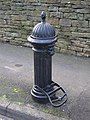
 19th C cast iron water hydrant - geograph.org.uk - 526716.jpg 480 × 640; 140 KB
-
 19th C cast iron water hydrant - geograph.org.uk - 618714.jpg 480 × 640; 124 KB
-
 19th C cast iron water hydrant - geograph.org.uk - 622542.jpg 480 × 640; 139 KB
-
 19th C cast iron water hydrant - geograph.org.uk - 623531.jpg 480 × 640; 133 KB
-
 19th C cast iron water hydrant - geograph.org.uk - 634803.jpg 480 × 640; 104 KB
-
 19th C cast iron water hydrant - geograph.org.uk - 675831.jpg 370 × 640; 77 KB
-
 19th C cast iron water hydrant - geograph.org.uk - 721449.jpg 480 × 640; 124 KB
-
 19th C cast iron water hydrant - geograph.org.uk - 721464.jpg 480 × 640; 126 KB
-

-
 20 Market Street - geograph.org.uk - 572412.jpg 480 × 640; 64 KB
-
 21 Hencotes - geograph.org.uk - 671664.jpg 640 × 479; 68 KB
-
 24 and 26 Hallstile Bank - geograph.org.uk - 530289.jpg 480 × 640; 104 KB
-
 27-31 Hallstile Bank - geograph.org.uk - 572388.jpg 640 × 480; 100 KB
_postbox_-_with_a_George_V_door,_Clayton_Street_-_geograph.org.uk_-_873649.jpg)
_postbox,_Belsize_Grove,_NW3_-_geograph.org.uk_-_762260.jpg)
_postbox,_Boscastle_Road_-_Woodsome_Road,_NW5_-_geograph.org.uk_-_1447147.jpg)
_postbox,_Church_Rise,_SE23_-_geograph.org.uk_-_899842.jpg)
_postbox,_Cromwell_Road,_SW5_-_geograph.org.uk_-_846126.jpg)
_postbox,_Daleham_Gardens,_NW3_-_geograph.org.uk_-_892526.jpg)
_postbox,_Fellows_Road_-_Merton_Rise,_NW3_-_geograph.org.uk_-_881975.jpg)
_postbox,_Fitzjohn%27s_Avenue_-_Maresfield_Gardens,_NW3_-_geograph.org.uk_-_892510.jpg)
_postbox,_Fleet_Road_-_Lawn_Road,_NW3_-_geograph.org.uk_-_889189.jpg)
_postbox,_Fortess_Road_-_Raveley_Street,_NW5_-_geograph.org.uk_-_1440188.jpg)
_postbox,_Lancaster_Drive_-_Belsize_Square,_NW3_-_geograph.org.uk_-_881962.jpg)
_postbox,_Longton_Avenue,_SE26_-_geograph.org.uk_-_900215.jpg)
_postbox,_Lyndhurst_Gardens_-_Wedderburn_Road,_NW3_-_geograph.org.uk_-_1073592.jpg)
_postbox,_Maresfield_Gardens,_NW3_-_geograph.org.uk_-_891966.jpg)
_postbox,_Netherhall_Gardens,_NW3_-_geograph.org.uk_-_891933.jpg)
_postbox,_Nevern_Square,_SW5_-_geograph.org.uk_-_846183.jpg)
_postbox,_Percy_Road,_W14_-_geograph.org.uk_-_890003.jpg)
_postbox,_Primrose_Hill_Road,_NW3_-_geograph.org.uk_-_846904.jpg)
_postbox,_Sunderland_Road,_SE23_-_geograph.org.uk_-_899831.jpg)
_postbox,_Tavistock_Road_-_Tavistock_Crescent,_W11_-_geograph.org.uk_-_883214.jpg)
_postbox,_Vale_of_Health,_NW3_-_geograph.org.uk_-_1071132.jpg)
_postbox,_Warwick_Road,_SW5_-_geograph.org.uk_-_846246.jpg)
_postbox,_Westmoreland_Road_-_Cumberland_Road_-_geograph.org.uk_-_937571.jpg)


_-_geograph.org.uk_-_720717.jpg)
_-_geograph.org.uk_-_720739.jpg)


_Tube_Station_-_geograph.org.uk_-_872621.jpg)

_Hadrian%27s_Wall_(2)_-_geograph.org.uk_-_837912.jpg)
_Hadrian%27s_Wall_-_geograph.org.uk_-_837908.jpg)
_Milecastle_33_-_geograph.org.uk_-_592666.jpg)
_ford_over_the_West_Allen_-_geograph.org.uk_-_413290.jpg)
_boggy_bit_-_geograph.org.uk_-_392366.jpg)
_old_mine_shaft_-_geograph.org.uk_-_720656.jpg)
_the_churchyard_of_St_Mary_The_Virgin,_Walthamstow_-_geograph.org.uk_-_899219.jpg)
_(former)_lock-keeper%27s_cottage_on_the_(former)_Surrey_Canal_-_geograph.org.uk_-_880620.jpg)
_boggy_bit_-_geograph.org.uk_-_391125.jpg)
_bracket_fungus_-_geograph.org.uk_-_844690.jpg)
_firebreak_in_the_forest_below_Black_Knowe_-_geograph.org.uk_-_909469.jpg)
_footbridge_over_Catton_Burn_-_geograph.org.uk_-_635948.jpg)
_footbridge_over_Halgut_Burn_-_geograph.org.uk_-_843627.jpg)
_old_mine_building_-_geograph.org.uk_-_417551.jpg)
_old_mine_shaft_-_geograph.org.uk_-_720650.jpg)
_Penfold_postbox,_Devonshire_Road,_SE23_-_geograph.org.uk_-_873455.jpg)
_Penfold_postbox,_Devonshire_Road,_SE23_-_royal_cipher_and_crest_-_geograph.org.uk_-_873460.jpg)
_sign_for_The_Bull_-_geograph.org.uk_-_911938.jpg)
_sign_for_The_Dolphin_-_geograph.org.uk_-_926191.jpg)
_sign_for_The_Fox_-_geograph.org.uk_-_838817.jpg)
_waterfall_on_Rookhope_Burn_-_geograph.org.uk_-_728905.jpg)
_sheep_hole_above_Middlehope_Burn_-_geograph.org.uk_-_697983.jpg)
_sheephole_in_a_drystone_wall_near_High_Scotch_Hall_-_geograph.org.uk_-_822095.jpg)
_sheephole_in_a_drystone_wall_near_Lonkley_Head_-_geograph.org.uk_-_822173.jpg)
_sheephole_in_drystone_wall_-_geograph.org.uk_-_849028.jpg)
_sheephole_in_drystone_wall_on_Red_Road_-_geograph.org.uk_-_703090.jpg)
_sheephole_near_Lynnshield_-_geograph.org.uk_-_614581.jpg)
_quarry_near_Walltown_-_geograph.org.uk_-_578293.jpg)
_moorland_-_geograph.org.uk_-_416583.jpg)
_lock-keeper%27s_cottage_on_the_(former)_Surrey_Canal_-_geograph.org.uk_-_880611.jpg)
_Notting_Hill_Post_Office,_W11_-_geograph.org.uk_-_873709.jpg)
_Primitive_Methodist_Chapel_-_geograph.org.uk_-_626189.jpg)
_old_mine_workings_-_geograph.org.uk_-_404295.jpg)
_Catton_-_geograph.org.uk_-_679213.jpg)
_Fishermen%27s_Window,_St_Margaret%27s_Church_-_geograph.org.uk_-_913070.jpg)
_house_where_Wilfrid_Wilson_Gibson,_Georgian_Poet,_was_born_-_geograph.org.uk_-_671768.jpg)
_Royal_London_Hospital_-_geograph.org.uk_-_889260.jpg)
_Allendale_Town_-_geograph.org.uk_-_618717.jpg)
_Belsize_Avenue_-_geograph.org.uk_-_777816.jpg)
_Bunhill_Row,_EC1_-_geograph.org.uk_-_805735.jpg)
_bus_destination_indicator_-_geograph.org.uk_-_881865.jpg)
_Catton_-_geograph.org.uk_-_691049.jpg)
_Catton_Moss_-_geograph.org.uk_-_416575.jpg)
_College_Crescent_-_geograph.org.uk_-_776036.jpg)
_Glen_Terrace_-_geograph.org.uk_-_806899.jpg)
_Glenloch_Road,_NW3_-_geograph.org.uk_-_777808.jpg)
_Great_North_Road,_N2_-_geograph.org.uk_-_805643.jpg)
_Guilford_Street,_WC1_-_geograph.org.uk_-_777742.jpg)
_Hadrian%27s_Wall_(2)_-_geograph.org.uk_-_837930.jpg)
_Hadrian%27s_Wall_(2)_-_geograph.org.uk_-_837968.jpg)
_Hadrian%27s_Wall_-_geograph.org.uk_-_837919.jpg)
_Hadrian%27s_Wall_-_geograph.org.uk_-_837959.jpg)
_Hexhamshire_Common_with_heather_in_bloom_-_geograph.org.uk_-_537449.jpg)
_Marchmont_Street,_WC1_-_geograph.org.uk_-_777679.jpg)
_Muggleswick_Common_-_geograph.org.uk_-_525865.jpg)
_Ouston_Fell_-_geograph.org.uk_-_420175.jpg)
_Quickcleugh_Moss_-_geograph.org.uk_-_752230.jpg)
_Station_Road_-_geograph.org.uk_-_692142.jpg)
_the_14th_C_town_walls_-_geograph.org.uk_-_911878.jpg)
_the_churchyard_of_St_Mary_The_Virgin,_Walthamstow_-_geograph.org.uk_-_899217.jpg)
_the_cricket_ground_on_Riding_Haugh_-_geograph.org.uk_-_639038.jpg)
_the_East_Gate,_Chesters_Fort_-_geograph.org.uk_-_1032018.jpg)
_the_tower_of_St_Andrew%27s_Church_-_north_side_-_geograph.org.uk_-_852087.jpg)
_the_West_Gate_at_Chesters_Fort_-_geograph.org.uk_-_1020871.jpg)
_Townfoot,_Slaley_-_geograph.org.uk_-_499107.jpg)
_Well_Rigg_-_geograph.org.uk_-_538768.jpg)
_Woburn_Place,_WC1_-_geograph.org.uk_-_777683.jpg)
_Wooley_-_geograph.org.uk_-_531375.jpg)
_sheephole_near_Pia_Troon_-_geograph.org.uk_-_680764.jpg)
_the_Old_Priory,_Hexham_Abbey_-_geograph.org.uk_-_671633.jpg)
_Penfold_postbox,_Shad_Thames,_SE1_-_geograph.org.uk_-_759727.jpg)
_Penfold_postbox,_Stowell_Street_-_geograph.org.uk_-_911759.jpg)
_Penfold_postbox,_Stowell_Street_-_royal_cipher_and_crest_-_geograph.org.uk_-_911769.jpg)
_Temple_of_Antenociticus_(2)_-_geograph.org.uk_-_837881.jpg)
_Temple_of_Antenociticus_(3)_-_geograph.org.uk_-_837888.jpg)
_Temple_of_Antenociticus_-_geograph.org.uk_-_837874.jpg)
_illiterate_anti-cyclist_notice_-_geograph.org.uk_-_805753.jpg)
_Castle_Stairs_-_geograph.org.uk_-_1018252.jpg)
_Allendale_Garage_-_geograph.org.uk_-_627121.jpg)
_Allendale_railway_station_-_geograph.org.uk_-_650951.jpg)
_Balham_signal_box_-_geograph.org.uk_-_899090.jpg)
_Wimbledon_A_signal_box_-_geograph.org.uk_-_897819.jpg)
_lead_smelting_flue_-_geograph.org.uk_-_603865.jpg)
_Hadrian%27s_Wall_-_Westgate_Road_(2)_-_geograph.org.uk_-_911792.jpg)
_Hadrian%27s_Wall_-_Westgate_Road_-_geograph.org.uk_-_911786.jpg)
_Hadrian%27s_Wall_east_of_Milecastle_33_-_geograph.org.uk_-_592802.jpg)
_Hadrian%27s_Wall_east_of_Milecastle_34_(2)_-_geograph.org.uk_-_948682.jpg)
_Hadrian%27s_Wall_east_of_Milecastle_34_-_geograph.org.uk_-_592773.jpg)
_Hadrian%27s_Wall_near_Shield_on_the_Wall_-_geograph.org.uk_-_592782.jpg)
_Hadrian%27s_Wall_near_Steel_Rigg_car_park_(2)_-_geograph.org.uk_-_747267.jpg)
_Hadrian%27s_Wall_west_of_Milecastle_34_-_geograph.org.uk_-_592767.jpg)
_the_Royal_Pavilion_Tavern_-_geograph.org.uk_-_879705.jpg)
_Condercum_(Benwell)_Roman_Fort_(2)_-_geograph.org.uk_-_837865.jpg)
_Condercum_(Benwell)_Roman_Fort_(3)_-_geograph.org.uk_-_837869.jpg)
_Condercum_(Benwell)_Roman_Fort_-_geograph.org.uk_-_837861.jpg)
_Milecastle_20_(Halton_Shields)_-_geograph.org.uk_-_1377065.jpg)
_Milecastle_22_(Portgate)_-_geograph.org.uk_-_1234711.jpg)
_Milecastle_25_(Codlawhill)_(2)_-_geograph.org.uk_-_1278858.jpg)
_Milecastle_27_(2)_-_geograph.org.uk_-_779937.jpg)
_Milecastle_27_-_geograph.org.uk_-_779926.jpg)
_Milecastle_32_-_geograph.org.uk_-_592657.jpg)
_Milecastle_34_-_geograph.org.uk_-_592694.jpg)
_Milecastle_38_(2)_-_geograph.org.uk_-_750626.jpg)
_Milecastle_38_(3)_-_geograph.org.uk_-_750972.jpg)
_Milecastle_38_(4)_-_geograph.org.uk_-_750975.jpg)
_Milecastle_38_-_geograph.org.uk_-_674778.jpg)
_Milecastle_40_-_geograph.org.uk_-_610092.jpg)
_Milecastle_41_-_geograph.org.uk_-_610141.jpg)
_Milecastle_44_-_geograph.org.uk_-_578353.jpg)
_Milecastle_45_-_geograph.org.uk_-_578487.jpg)
_Milecastle_47_(2)_-_geograph.org.uk_-_1551268.jpg)
_Milecastle_50_(Stone_Wall)_(High_House)_-_geograph.org.uk_-_1356771.jpg)
_Turret_22a_-_geograph.org.uk_-_1234724.jpg)
_Turret_22b_-_geograph.org.uk_-_1234730.jpg)
_Turret_33a_-_geograph.org.uk_-_592676.jpg)
_Turret_39a_-_geograph.org.uk_-_599514.jpg)
_Turret_39b_-_geograph.org.uk_-_599723.jpg)
_Castle_Stairs_-_geograph.org.uk_-_1018249.jpg)
_Hadrian%27s_Wall_-_geograph.org.uk_-_837970.jpg)
_%22hush%22_near_Allenheads_(2)_-_geograph.org.uk_-_720658.jpg)
_%22hush%22_near_Allenheads_-_geograph.org.uk_-_453280.jpg)
_cleugh_feeding_into_Anchey_Sike_-_geograph.org.uk_-_416528.jpg)
_minor_road_near_Bellingham_-_geograph.org.uk_-_493754.jpg)
_old_railway_goods_van_-_geograph.org.uk_-_413181.jpg)
_Tyne_Bridge_-_geograph.org.uk_-_927782.jpg)


_-_geograph.org.uk_-_911881.jpg)
_-_geograph.org.uk_-_911883.jpg)

_-_geograph.org.uk_-_899237.jpg)


_-_geograph.org.uk_-_738794.jpg)
_-_geograph.org.uk_-_738797.jpg)
_-_geograph.org.uk_-_738800.jpg)
_-_geograph.org.uk_-_738803.jpg)
_-_geograph.org.uk_-_738805.jpg)
_-_geograph.org.uk_-_738807.jpg)
_-_geograph.org.uk_-_738808.jpg)
_-_geograph.org.uk_-_738812.jpg)


,_North_Transept,_Hexham_Abbey_-_geograph.org.uk_-_749212.jpg)