Category:Images by John Haynes
Jump to navigation
Jump to search

Media in category "Images by John Haynes"
The following 200 files are in this category, out of 1,747 total.
(previous page) (next page)-
 "Dropped bridge" near Llynclys - geograph.org.uk - 51404.jpg 640 × 480; 156 KB
-
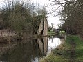
 "Pollets" Bridge on the Llangollen Canal - geograph.org.uk - 51988.jpg 640 × 480; 140 KB
-
 A 483 T goes over the Afon Dyfrdwy - geograph.org.uk - 69293.jpg 640 × 480; 97 KB
-
 A by-product of grassland improvement - geograph.org.uk - 1657813.jpg 640 × 428; 100 KB
-
 A by-product of grassland improvement - geograph.org.uk - 1670263.jpg 640 × 441; 115 KB
-
 A drain on the moss - geograph.org.uk - 595286.jpg 640 × 480; 136 KB
-
 A good recently erected sheep fence - geograph.org.uk - 1657797.jpg 640 × 428; 99 KB
-
 A great winter's day - geograph.org.uk - 1650273.jpg 640 × 428; 87 KB
-
 A huge complex of old and new - geograph.org.uk - 70628.jpg 640 × 480; 97 KB
-
 A lane to Glyn Ceiriog - geograph.org.uk - 1254254.jpg 640 × 428; 66 KB
-
 A long steady drag up the quarry road - geograph.org.uk - 1654023.jpg 640 × 428; 119 KB
-
 A New Hedge - geograph.org.uk - 366746.jpg 640 × 480; 97 KB
-

-
 A sign of the times - geograph.org.uk - 69303.jpg 640 × 480; 105 KB
-
 A small area of "improved" grassland - geograph.org.uk - 1636998.jpg 640 × 488; 115 KB
-
 A spectacular view - geograph.org.uk - 72077.jpg 640 × 480; 108 KB
-
 A stand of mature European Larch - geograph.org.uk - 1637086.jpg 640 × 428; 112 KB
-
 A steady climb up the valley - geograph.org.uk - 1638302.jpg 640 × 428; 115 KB
-
 A steady rise up the hill - geograph.org.uk - 1291574.jpg 640 × 428; 113 KB
-
 A wintery track - geograph.org.uk - 1639731.jpg 640 × 428; 106 KB
-
 A458 crosses the Montgomery Canal - geograph.org.uk - 52442.jpg 640 × 480; 122 KB
-
 A5 north, the Nesscliffe by-pass - geograph.org.uk - 541176.jpg 640 × 480; 82 KB
-
 A5 south, the Nesscliffe by-pass - geograph.org.uk - 541155.jpg 640 × 480; 92 KB
-
 Abandoned pig huts and feeders - geograph.org.uk - 540107.jpg 640 × 480; 83 KB
-
 Abandoned quarry - geograph.org.uk - 1254241.jpg 640 × 428; 104 KB
-
-
 Aber-gwern quarry - geograph.org.uk - 237725.jpg 640 × 480; 134 KB
-
 ABP abattoir and meat plant - geograph.org.uk - 540124.jpg 640 × 480; 61 KB
-
 Abutments for a new lift bridge - geograph.org.uk - 525846.jpg 640 × 480; 127 KB
-
 Access track beside the Afon Eglwyseg - geograph.org.uk - 1219763.jpg 640 × 428; 112 KB
-
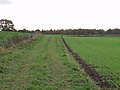 Access track beside the winter barley - geograph.org.uk - 598872.jpg 640 × 480; 76 KB
-
 Afon Clywedog in Erddig Park - geograph.org.uk - 51774.jpg 640 × 480; 115 KB
-
 Afon Dyfrdwy at Garth y dwr - geograph.org.uk - 55160.jpg 640 × 480; 169 KB
-
 Afon Dyfrdwy at Groeslwyd - geograph.org.uk - 55155.jpg 640 × 480; 125 KB
-
 Afon Dyfrdwy at Gwerclas - geograph.org.uk - 1692007.jpg 640 × 404; 87 KB
-

-
-
 Afon Dyfrdwy in December - geograph.org.uk - 1639659.jpg 640 × 428; 77 KB
-
 Afon Dyfrdwy in December - geograph.org.uk - 1639717.jpg 640 × 428; 86 KB
-
 Afon Dyfrdwy in mid-winter - geograph.org.uk - 1639666.jpg 640 × 428; 87 KB
-
 Afon Dyfrdwy in the evening sunshine - geograph.org.uk - 593653.jpg 640 × 480; 73 KB
-
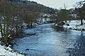
 Afon Dyfrdwy in winter - geograph.org.uk - 1650332.jpg 640 × 428; 104 KB
-
 Afon Dyfrdwy just east of Carrog - geograph.org.uk - 55099.jpg 640 × 480; 124 KB
-
-
 Afon Dyfrdwy looking very wintery - geograph.org.uk - 1650219.jpg 640 × 428; 115 KB
-
 Afon Dyfrdwy near Pen y Garth - geograph.org.uk - 257377.jpg 640 × 480; 117 KB
-
 Afon Dyfrdwy near Rhydonnen - geograph.org.uk - 237133.jpg 640 × 480; 156 KB
-
 Afon Hafren (River Severn) at Tirymynach - geograph.org.uk - 579602.jpg 640 × 480; 116 KB
-
-
 Afon Hafren near Rhyd-esgyn - geograph.org.uk - 579514.jpg 640 × 480; 81 KB
-
 After dinner nap - geograph.org.uk - 617288.jpg 640 × 480; 116 KB
-
 All ready for lambing - geograph.org.uk - 1692080.jpg 640 × 428; 86 KB
-
 All Saints Church at Pen-y-lan - geograph.org.uk - 63331.jpg 640 × 480; 126 KB
-
 All Saints Parish Church, Trefonen - geograph.org.uk - 555451.jpg 640 × 480; 97 KB
-
 Althrey Woodhouse near Bangor-is-y-coed - geograph.org.uk - 65935.jpg 640 × 480; 139 KB
-
 An abandoned quarry hidden by whins - geograph.org.uk - 1254229.jpg 640 × 428; 92 KB
-
 Another load of milk for the creamery - geograph.org.uk - 602335.jpg 640 × 480; 84 KB
-

-

-
 Another view of the clearfell - geograph.org.uk - 1251598.jpg 640 × 428; 105 KB
-
 Approaching Bryn Cottage - geograph.org.uk - 1218301.jpg 640 × 428; 114 KB
-
 Approaching Tarbet Bay - geograph.org.uk - 186850.jpg 640 × 480; 107 KB
-
-
 Aqueduct over the Afon Efyrnwy - geograph.org.uk - 47538.jpg 640 × 480; 97 KB
-
 Artificial pond - geograph.org.uk - 1218121.jpg 640 × 428; 74 KB
-
 Ash tree in the afternoon sun - geograph.org.uk - 598866.jpg 640 × 480; 48 KB
-
 Assistant for the big stones - geograph.org.uk - 1637042.jpg 640 × 428; 91 KB
-
 Derelict Chapel at Aston Hall - geograph.org.uk - 204139.jpg 640 × 480; 114 KB
-
 Aston Farm at Aston Square - geograph.org.uk - 204053.jpg 640 × 480; 90 KB
-
 Aston Hall Oswestry - geograph.org.uk - 204135.jpg 640 × 480; 122 KB
-
 Awaiting the end of the season clean - geograph.org.uk - 609305.jpg 640 × 480; 92 KB
-
 Back into the concrete trough - geograph.org.uk - 644171.jpg 640 × 480; 132 KB
-
 Back Lane Cottage - geograph.org.uk - 598681.jpg 640 × 480; 101 KB
-
 Balcarres House - geograph.org.uk - 248731.jpg 640 × 480; 139 KB
-
 Bangor-is-y-coed Race Course - geograph.org.uk - 65933.jpg 640 × 480; 66 KB
-
 Bank improvements on the Llangollen Canal - geograph.org.uk - 637616.jpg 640 × 480; 105 KB
-
 Bank protection on the Llangollen Canal - geograph.org.uk - 637620.jpg 640 × 480; 122 KB
-
 Barn conversion on the edge of Bagley - geograph.org.uk - 631352.jpg 640 × 480; 81 KB
-
 Beautiful stone dyke - geograph.org.uk - 1633457.jpg 640 × 405; 112 KB
-
 Belt and braces - geograph.org.uk - 1254422.jpg 640 × 428; 67 KB
-
 Benefits of re-opening a canal - geograph.org.uk - 585237.jpg 640 × 480; 98 KB
-
 Bersham Colliery Bing at Rhostyllen - geograph.org.uk - 51429.jpg 640 × 480; 105 KB
-
 Bersham Iron Works by Wrecsam - geograph.org.uk - 54754.jpg 640 × 480; 136 KB
-
 Berwyn Tunnel - geograph.org.uk - 52503.jpg 640 × 480; 150 KB
-
 Bettisfield Windmill - geograph.org.uk - 598775.jpg 640 × 480; 56 KB
-
 Big bale feeder with roof - geograph.org.uk - 1657880.jpg 640 × 440; 101 KB
-

-

-
 Birch and alder scrub on Fenn's Moss - geograph.org.uk - 598657.jpg 640 × 480; 91 KB
-
 Birthday treat - geograph.org.uk - 53675.jpg 640 × 480; 76 KB
-
 Black and white or white and black - geograph.org.uk - 609208.jpg 640 × 480; 83 KB
-
 Black Park Methodist Chapel - geograph.org.uk - 68800.jpg 640 × 480; 89 KB
-
 Blaen-Bache steading - geograph.org.uk - 1251320.jpg 640 × 428; 77 KB
-
 Boaters view of the aqueduct - geograph.org.uk - 640563.jpg 640 × 480; 91 KB
-
 Boating Lake at Craigtoun Park - geograph.org.uk - 57960.jpg 640 × 480; 104 KB
-
 Boodles Bridge (no.4 Prees Branch SUC) - geograph.org.uk - 52677.jpg 640 × 480; 175 KB
-
 Border post - geograph.org.uk - 595277.jpg 640 × 480; 90 KB
-
 Borras Hall - geograph.org.uk - 77472.jpg 640 × 480; 75 KB
-

-
 Bothy and Shearing Shed at Hafod Fudr - geograph.org.uk - 71690.jpg 640 × 480; 138 KB
-

-
 Breidden Hill surrounded in mist - geograph.org.uk - 51511.jpg 640 × 480; 80 KB
-
 Brick Works Basin, Trefor - geograph.org.uk - 167364.jpg 640 × 480; 109 KB
-
 Bridge 35 on Shropshire Union Canal - geograph.org.uk - 52860.jpg 640 × 480; 112 KB
-

-
 Bridge 41 Shropshire Union Canal - geograph.org.uk - 52877.jpg 640 × 480; 139 KB
-
 Bridge 44W in mid winter - geograph.org.uk - 1634478.jpg 640 × 428; 95 KB
-
 Bridge 44W in the snow - geograph.org.uk - 1653960.jpg 640 × 428; 87 KB
-
 Bridge abutments on redundant railway - geograph.org.uk - 594232.jpg 640 × 480; 93 KB
-
 Bridge at Henlle Hall, Chirk Bank - geograph.org.uk - 50548.jpg 640 × 480; 154 KB
-
 Bridge No 34 Shropshire Union Canal - geograph.org.uk - 52865.jpg 640 × 480; 134 KB
-
 Bridge no. 3 on the Llangollen Canal - geograph.org.uk - 51971.jpg 640 × 480; 112 KB
-
 Bridge on the Montgomery Canal - geograph.org.uk - 51077.jpg 640 × 480; 164 KB
-
 Bridge over Afon Cwm-mynach - geograph.org.uk - 1635383.jpg 640 × 428; 125 KB
-
 Bridge over Afon Dyfrdwy - geograph.org.uk - 1671460.jpg 640 × 428; 90 KB
-
 Bridge over the Afon Nadroedd - geograph.org.uk - 71638.jpg 640 × 480; 104 KB
-
 Bridlepath up the hill - geograph.org.uk - 1659511.jpg 640 × 435; 104 KB
-
 Bridleway near Welshampton - geograph.org.uk - 598676.jpg 640 × 480; 93 KB
-
 Bryn Cottage - geograph.org.uk - 1218277.jpg 640 × 428; 117 KB
-
 Bryn Mawr from The Montgomery Canal - geograph.org.uk - 571453.jpg 640 × 480; 115 KB
-
 Bryn-Perthi Farm - geograph.org.uk - 580093.jpg 640 × 480; 95 KB
-
 Bryn-y-plentyn from behind the hedge - geograph.org.uk - 204047.jpg 640 × 480; 78 KB
-
 Buildings and houses at Gronwen - geograph.org.uk - 555528.jpg 640 × 480; 86 KB
-
 Buildings over the years - geograph.org.uk - 1254145.jpg 640 × 428; 65 KB
-

-
 Caegoody - geograph.org.uk - 366753.jpg 640 × 480; 78 KB
-
 Cairn on the Berwyns - geograph.org.uk - 1291217.jpg 640 × 428; 65 KB
-
 Calm water and frozen towing path - geograph.org.uk - 1634422.jpg 640 × 428; 127 KB
-
 Calon Wen sign - geograph.org.uk - 77471.jpg 640 × 480; 120 KB
-
 Can I be on Geographs - geograph.org.uk - 540022.jpg 640 × 480; 96 KB
-

-
 Canal Bridge at Llanymynech - geograph.org.uk - 51399.jpg 640 × 480; 132 KB
-
 Canal feeder on a winters day - geograph.org.uk - 1650297.jpg 640 × 428; 112 KB
-
-
 Canal restoration, the final phase - geograph.org.uk - 563834.jpg 640 × 480; 110 KB
-
 Canal restoration, the final touches - geograph.org.uk - 585216.jpg 640 × 480; 95 KB
-
 Canal Road crosses the Montgomery Canal - geograph.org.uk - 51450.jpg 640 × 480; 141 KB
-
 Canal side cottages - geograph.org.uk - 1650209.jpg 640 × 428; 90 KB
-
 Canalside maintenance - geograph.org.uk - 585244.jpg 640 × 480; 117 KB
-
 Canalside street - geograph.org.uk - 1211327.jpg 640 × 428; 67 KB
-
 Capel Hebron at Rhewl - geograph.org.uk - 55084.jpg 640 × 480; 95 KB
-
 Car park for the offices at Plas Yoly - geograph.org.uk - 248630.jpg 640 × 480; 123 KB
-
 Carreghofa Farm buildings - geograph.org.uk - 578134.jpg 640 × 480; 68 KB
-
 Carreghofa Hall farm buildings - geograph.org.uk - 578144.jpg 640 × 480; 69 KB
-
 Carreghofa Locks - geograph.org.uk - 52478.jpg 640 × 480; 142 KB
-
 Carriage Driving in Erddig Park - geograph.org.uk - 570557.jpg 640 × 480; 114 KB
-
 Carriage driving in Erddig Park - geograph.org.uk - 570641.jpg 640 × 480; 109 KB
-
 Castell Dinas Bran on Christmas Day - geograph.org.uk - 1632394.jpg 640 × 428; 76 KB
-
 Castell Dinas Brân, Llangollen - geograph.org.uk - 50103.jpg 640 × 480; 82 KB
-
 Cattle grazing at Colfryn - geograph.org.uk - 548934.jpg 640 × 480; 89 KB
-

-
 Cattle grazing near Crab Mill Farm - geograph.org.uk - 249029.jpg 640 × 480; 74 KB
-

-
 Cattle grid onto the open hill - geograph.org.uk - 1654013.jpg 640 × 428; 120 KB
-
 Cattle in the Llangollen Canal - geograph.org.uk - 586116.jpg 640 × 480; 116 KB
-
 Cattle shed at Gwerclas - geograph.org.uk - 1691981.jpg 640 × 429; 106 KB
-
 Cefn Park, Wrecsam - geograph.org.uk - 161683.jpg 640 × 352; 107 KB
-
 Cefn Park, Wrexham - geograph.org.uk - 160914.jpg 640 × 480; 112 KB
-
 Cefn-Mawr.jpg 640 × 428; 79 KB
-
 Changing times, school being up-dated - geograph.org.uk - 65626.jpg 640 × 480; 69 KB
-
 Cheese store at Ridleywood - geograph.org.uk - 72125.jpg 640 × 480; 107 KB
-
 Chirk Cutting on the Llangollen Canal - geograph.org.uk - 51049.jpg 511 × 640; 142 KB
-
 Chopped maize - geograph.org.uk - 598699.jpg 640 × 480; 102 KB
-
 Chrickheath Wharf on the Montgomery Canal - geograph.org.uk - 51070.jpg 640 × 480; 147 KB
-
 Church at Kinnerley - geograph.org.uk - 541096.jpg 640 × 480; 93 KB
-
 Church Row St. Martins - geograph.org.uk - 200751.jpg 640 × 480; 102 KB
-
 Clear fell at Pen Bryn-y-fawnog - geograph.org.uk - 71646.jpg 640 × 480; 112 KB
-
 Clear fell in Coed Ty-cerrig - geograph.org.uk - 1801449.jpg 640 × 428; 110 KB
-

-
 Clearing scrub from the derelict canal - geograph.org.uk - 602258.jpg 640 × 480; 119 KB
-
 Clwydian Way at Glyn - geograph.org.uk - 242949.jpg 640 × 480; 138 KB
-
 Coming up the bank out of England - geograph.org.uk - 69354.jpg 640 × 480; 108 KB
-
 Coniferous windbreak - geograph.org.uk - 203125.jpg 640 × 480; 116 KB
-

-
 Converted Chapel at Eglwyseg - geograph.org.uk - 50118.jpg 640 × 480; 136 KB
-
 Cook's Bridge near Trevalyn - geograph.org.uk - 77684.jpg 640 × 480; 136 KB
-
 Corwen Railway Station.jpg 640 × 383; 58 KB
-
 Corwen sewage works - geograph.org.uk - 1671557.jpg 640 × 429; 102 KB
-
 Cottage at Pikes End - geograph.org.uk - 598855.jpg 640 × 480; 81 KB
-
 Cottage hidden amongst the trees - geograph.org.uk - 1291520.jpg 640 × 428; 109 KB
-
 Cottage with a fresh coat of paint - geograph.org.uk - 631384.jpg 640 × 480; 72 KB
-
 Cottages at Belan Locks - geograph.org.uk - 617388.jpg 640 × 480; 100 KB
-
 Cottages at Cadney Bank - geograph.org.uk - 598752.jpg 640 × 480; 82 KB
-
 Cottages at Rhos Pengwern - geograph.org.uk - 1251636.jpg 640 × 428; 69 KB
-

-
 Course of Montgomery Canal at Pant - geograph.org.uk - 51038.jpg 640 × 511; 144 KB
-
 Course of redundant railway - geograph.org.uk - 594971.jpg 640 × 480; 122 KB
-
 Course of redundant railway - geograph.org.uk - 595296.jpg 640 × 480; 93 KB
-
-
 Cow and calf grazing Cadney Moss - geograph.org.uk - 598765.jpg 640 × 480; 156 KB
-
 Crab Row dairy farm, Pen-y-lan - geograph.org.uk - 151320.jpg 640 × 480; 108 KB
-
 Crag emerging from the trees - geograph.org.uk - 1638349.jpg 640 × 428; 80 KB
-

-
 Craig Yr Aderyn - geograph.org.uk - 1218351.jpg 640 × 428; 112 KB
-
 Craigmore Cottage, near Kinloid - geograph.org.uk - 194940.jpg 640 × 480; 137 KB
-

-
 Croesiolyn by Tower Wood - geograph.org.uk - 72165.jpg 640 × 480; 105 KB
-
 Croesnewydd Hall, Wrecsam - geograph.org.uk - 160928.jpg 640 × 480; 161 KB
-
 Crop spraying contractor moves on - geograph.org.uk - 598812.jpg 640 × 480; 86 KB
-
 Crosemere Hall - geograph.org.uk - 599029.jpg 640 × 480; 87 KB


_at_Tirymynach_-_geograph.org.uk_-_579602.jpg)
_from_Maginnis_Bridge_-_geograph.org.uk_-_582593.jpg)


_-_geograph.org.uk_-_52677.jpg)


