Category:Images by Dysdera
Jump to navigation
Jump to search

Media in category "Images by Dysdera"
The following 55 files are in this category, out of 55 total.
-
 Bottom lock at Neptunes Staircase - geograph.org.uk - 523.jpg 640 × 480; 42 KB
-
 Conwy Castle - geograph.org.uk - 509.jpg 640 × 480; 51 KB
-
 Cove Harbour.jpg 640 × 480; 45 KB
-
 Dam on Llyn Brianne reservoir - geograph.org.uk - 610.jpg 640 × 480; 40 KB
-
 Dover Docks viewed from the clifftop - geograph.org.uk - 521.jpg 640 × 480; 66 KB
-
 Footdee Village - geograph.org.uk - 519.jpg 640 × 480; 44 KB
-
 Gate to Clarence Yard - geograph.org.uk - 510.jpg 640 × 480; 44 KB
-
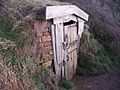 Hawker's Hut.jpg 640 × 480; 70 KB
-
 Level crossing near the village of Beal - geograph.org.uk - 1763.jpg 640 × 480; 38 KB
-
 Lindisfarne viewed across the mudflats - geograph.org.uk - 1769.jpg 640 × 480; 27 KB
-
 Lock at the top of Loch Ness - geograph.org.uk - 524.jpg 640 × 480; 48 KB
-
 Looking into 'The Pass of Glencoe' - geograph.org.uk - 503.jpg 640 × 480; 54 KB
-

-
 Looking NE within SE8222 - geograph.org.uk - 496.jpg 640 × 480; 59 KB
-

-

-
 Looking WNW from Lee on Solent seafront - geograph.org.uk - 828.jpg 640 × 480; 42 KB
-

-
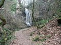 Melin Court Falls - geograph.org.uk - 518.jpg 640 × 480; 97 KB
-

-
 No Man's Land off Handfast Point - geograph.org.uk - 608.jpg 640 × 480; 51 KB
-

-
 Pilchard Inn and Hotel on Burgh Island - geograph.org.uk - 607.jpg 640 × 480; 36 KB
-
 Portsmouth Harbour viewed from Gosport - geograph.org.uk - 512.jpg 640 × 480; 41 KB
-
 Privett Church - geograph.org.uk - 1789.jpg 640 × 480; 27 KB
-

-

-

-

-

-
 View from the monument at the hilltop - geograph.org.uk - 507.jpg 640 × 480; 30 KB
-

-
 VOR Beacon on the cliffs near Dover - geograph.org.uk - 711.jpg 640 × 480; 44 KB
-

-

-
 Ferry Gardens at Gosport looking North - geograph.org.uk - 513.jpg 640 × 480; 54 KB
-
 Footpath marker on the Monarchs Way. - geograph.org.uk - 1782.jpg 640 × 480; 74 KB
-
 Geographical centre of Wales - geograph.org.uk - 506.jpg 640 × 480; 34 KB
-
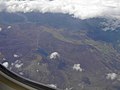 Loch Cuaich viewed from 14500 feet - geograph.org.uk - 1798.jpg 640 × 480; 27 KB
-

-
 Looking North towards the road - geograph.org.uk - 497.jpg 640 × 480; 59 KB
-

-
 Near Bungalow station on Snaefell - geograph.org.uk - 604.jpg 640 × 480; 17 KB
-
 Near Bungalow station on Snaefell Pike - geograph.org.uk - 989.jpg 640 × 480; 15 KB
-

-
 Port of Douglas as the ship approaches. - geograph.org.uk - 603.jpg 640 × 480; 37 KB
-

-
 Teglease Down Looking North - geograph.org.uk - 1783.jpg 640 × 480; 37 KB
-

-

-
 Transporter bridge over the River Tees - geograph.org.uk - 1758.jpg 640 × 480; 29 KB
-
 United Reformed Church, Bury Road - geograph.org.uk - 516.jpg 640 × 480; 49 KB
-

-
 View of Douglas from Onchan - geograph.org.uk - 606.jpg 640 × 480; 40 KB
-
 Workhouse Lake looking East - geograph.org.uk - 827.jpg 640 × 480; 26 KB


_-_geograph.org.uk_-_505.jpg)


