Category:Igreja de São Vicente de Sousa
Jump to navigation
Jump to search
| Object location | | View all coordinates using: OpenStreetMap |
|---|
church building in Felgueiras Municipality, Porto District, Portugal  | |||||
| Upload media | |||||
| Instance of | |||||
|---|---|---|---|---|---|
| Location | Sousa, Torrados e Sousa, Felgueiras, Porto, Portugal | ||||
| Heritage designation | |||||
| Religion or worldview | |||||
 | |||||
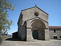
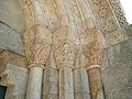
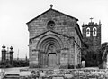
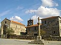
Português: Igreja de São Vicente de Sousa / Igreja Paroquial de Sousa / Igreja de São Vicente. Em Portugal, Porto, Felgueiras, Sousa.
|
This monument is classified as
Monumento Nacional .It is indexed in the IGESPAR database ( Instituto de Gestão do Património Arquitectónico e Arqueológico ), under the reference 71124.It is indexed in the SIPA database (Sistema de Informação para o Património Arquitectónico) under the reference 4857. |
Media in category "Igreja de São Vicente de Sousa"
The following 15 files are in this category, out of 15 total.
-
 Iglesia de São Vicente Mártir de Sousa (3555972501).jpg 3,264 × 2,448; 1.46 MB
-
 Iglesia de São Vicente Mártir de Sousa (3556089131).jpg 3,264 × 2,448; 1.57 MB
-
 Iglesia de São Vicente Mártir de Sousa (3556090561).jpg 3,264 × 2,448; 1.41 MB
-
 Iglesia de São Vicente Mártir de Sousa (3556897622).jpg 3,264 × 2,448; 1.57 MB
-
 Iglesia de São Vicente Mártir de Sousa (3556898990).jpg 3,264 × 2,448; 1.53 MB
-
 Iglesia de São Vicente Mártir de Sousa (5812742798).jpg 3,264 × 2,448; 1.78 MB
-
 Igreja de São Vicente de Sousa (Portugal) (8353428937).jpg 3,968 × 2,976; 7.3 MB
-
 Igreja de São Vicente de Sousa 001.jpg 1,685 × 1,191; 527 KB
-
 Igreja de São Vicente de Sousa 005.jpg 2,500 × 1,875; 751 KB
-
 Igreja de São Vicente de Sousa, Felgueiras (5820376789).jpg 1,757 × 2,522; 831 KB
-
 Igreja de São Vicente de Sousa, Felgueiras, Portugal (3606249991).jpg 2,790 × 2,019; 534 KB
-
 Igreja de São Vicente de Sousa, Felgueiras, Portugal (3606250239).jpg 1,825 × 2,750; 681 KB
-
 Igreja de São Vicente de Sousa.jpg 3,264 × 2,448; 1.47 MB
-
 Igreja românica de Sousa - Felgueiras - Portugal (384638072).jpg 1,280 × 936; 235 KB
-
 Retábulo-mor da Igreja de São Vicente de Sousa (5821011404).jpg 1,416 × 1,441; 301 KB
.jpg)
.jpg)
.jpg)
.jpg)
.jpg)
.jpg)
_(8353428937).jpg)


.jpg)
.jpg)
.jpg)
.jpg)
.jpg)
Categories:
- Monumentos Nacionais in Porto (district)
- Classified monuments in Felgueiras
- Romanesque churches in Porto (district)
- Vincent of Saragossa churches in Portugal
- Churches in Felgueiras
- Classified churches in Porto (district)
- Churches in Portugal classified as Monumento Nacional
- 13th-century churches in Portugal
- Sousa (Felgueiras)
- Torrados e Sousa