Category:Husborne Crawley
Jump to navigation
Jump to search
English: Husborne Crawley is a small village in Bedfordshire, located close to Junction 13 of the M1 motorway. The village touches the borders of the Woburn Abbey estate on one side, and the village of Aspley Guise on the other. It has a small church and a primary school, and a nineteenth-century manor house in its own grounds, known as Crawley Park. The Crawley Park estate is privately owned, and features some extremely well-preserved wooden-framed mediaeval cottages.
small village and civil parish in Bedfordshire, England  | |||||
| Upload media | |||||
| Instance of | |||||
|---|---|---|---|---|---|
| Location | Central Bedfordshire, Bedfordshire, East of England, England | ||||
| Said to be the same as | Husborne Crawley (Wikimedia duplicated page, civil parish) | ||||
 | |||||
Subcategories
This category has only the following subcategory.
H
Media in category "Husborne Crawley"
The following 103 files are in this category, out of 103 total.
-
 A4012 looking NNE - geograph.org.uk - 1412882.jpg 640 × 480; 71 KB
-
 A4012 looking SW - geograph.org.uk - 1412884.jpg 640 × 480; 86 KB
-

-
 A4012 northbound - geograph.org.uk - 5510360.jpg 640 × 480; 61 KB
-
 A421 at M1 junction 13 - geograph.org.uk - 5622915.jpg 640 × 428; 76 KB
-
 A421 Bridge, M1 - geograph.org.uk - 4730438.jpg 640 × 410; 42 KB
-
 A421 crossing the M1 - geograph.org.uk - 2670438.jpg 800 × 506; 37 KB
-
 A507 towards Ampthill - geograph.org.uk - 4729221.jpg 640 × 480; 76 KB
-
 Amazon warehouse - geograph.org.uk - 642218.jpg 640 × 480; 81 KB
-
-
 Barn off Bedford Road - geograph.org.uk - 4729096.jpg 640 × 480; 55 KB
-
 Bridge over the M1, Junction 13 - geograph.org.uk - 4327113.jpg 640 × 402; 72 KB
-
 Bungalow on the hill - geograph.org.uk - 3109869.jpg 1,600 × 1,067; 424 KB
-
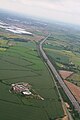
 Central Bedfordshire , M1 Motorway - geograph.org.uk - 5979110.jpg 6,000 × 4,000; 6.31 MB
-
 Central Bedfordshire , M1 Motorway - geograph.org.uk - 5979112.jpg 6,000 × 4,000; 5.94 MB
-
 Central Bedfordshire , M1 Motorway - geograph.org.uk - 5979870.jpg 6,000 × 4,000; 6.04 MB
-
 Coach Office, Woburn Safari Park - geograph.org.uk - 908984.jpg 640 × 256; 28 KB
-
 Cottages opposite Woburn Abbey - geograph.org.uk - 5578570.jpg 1,859 × 1,395; 635 KB
-
 Crawleyheath Farm at Woburn Safari Park - geograph.org.uk - 3248483.jpg 3,264 × 2,448; 1.47 MB
-
 DoveBakersCart.JPG 991 × 894; 311 KB
-
 Entrance to Woburn Safari Park - geograph.org.uk - 217722.jpg 640 × 480; 151 KB
-
 Entrance to Woburn Safari Park - geograph.org.uk - 2628764.jpg 3,872 × 2,592; 4.83 MB
-

-
 Farm track off Ridgmont Road - geograph.org.uk - 4729085.jpg 640 × 480; 103 KB
-
 Farmland off Ridgmont Road - geograph.org.uk - 4628329.jpg 640 × 480; 75 KB
-
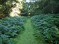 Fern edged path - geograph.org.uk - 1412880.jpg 640 × 480; 102 KB
-
 Ferns on Dean Hills - geograph.org.uk - 3519733.jpg 1,200 × 1,600; 822 KB
-
 Footpath to Church End - geograph.org.uk - 3109876.jpg 1,600 × 1,068; 738 KB
-
 GOC Woburn 076 Lion sculpture, Woburn Safari Park (22835235579).jpg 3,879 × 2,913; 3.3 MB
-
 GOC Woburn 106 Crawley Lodge, Husborne Crawley (23236867905).jpg 4,288 × 3,216; 3.71 MB
-
 GOC Woburn 107 Woburn Safari Park (22868895559).jpg 3,766 × 2,825; 3.46 MB
-
 GOC Woburn 108 1–3 Turnpike Road, Husborne Crawley (22875545337).jpg 3,614 × 2,705; 2.88 MB
-
 GOC Woburn 109 Crawley Lodge, Husborne Crawley (22642547693).jpg 3,223 × 2,415; 2.23 MB
-
 Grazing, Husborne Crawley - geograph.org.uk - 4628331.jpg 640 × 480; 62 KB
-

-
 Husborne Crawley - geograph.org.uk - 147368.jpg 640 × 427; 71 KB
-
 Husborne Crawley 20th Century Map.png 518 × 302; 379 KB
-
 Husborne Crawley Hall - geograph.org.uk - 1311062.jpg 640 × 480; 78 KB
-
 Husborne Crawley Lower School - geograph.org.uk - 1311065.jpg 640 × 480; 66 KB
-
 Husborne Crawley Population Time Series 1801-2011.jpg 720 × 407; 47 KB
-
 Husborne Crawley village hall - geograph.org.uk - 3109890.jpg 1,600 × 1,069; 362 KB
-
 Husborne Crawley village hall - geograph.org.uk - 5578571.jpg 2,048 × 1,536; 1.51 MB
-
 Into the Safari Park - geograph.org.uk - 3138917.jpg 1,600 × 1,067; 473 KB
-
 J13 overbridge, M1 - geograph.org.uk - 4699247.jpg 640 × 368; 36 KB
-
 J13 overbridge, M1 - geograph.org.uk - 4730018.jpg 640 × 426; 57 KB
-
 Jumbo - geograph.org.uk - 1412890.jpg 640 × 480; 62 KB
-
 Lion at Woburn Safari Park - geograph.org.uk - 1269822.jpg 640 × 480; 103 KB
-

-
 M1 motorway - A421 bridge, Ridgmont - geograph.org.uk - 2897331.jpg 640 × 480; 53 KB
-
 M1 motorway - junction 13 bridge - geograph.org.uk - 2897328.jpg 640 × 480; 55 KB
-
 M1 motorway approaching junction 13 - geograph.org.uk - 2897315.jpg 640 × 480; 49 KB
-

-

-
 M1 motorway near Ridgmont - geograph.org.uk - 2897312.jpg 640 × 480; 48 KB
-
 M1 near Junction 13 - geograph.org.uk - 4326039.jpg 640 × 458; 90 KB
-

-
 Mill Road, Ridgmont - geograph.org.uk - 5309228.jpg 2,048 × 1,536; 1.47 MB
-
 Northbound M1, Exit at Ridgmont Junction - geograph.org.uk - 6262005.jpg 800 × 534; 537 KB
-

-
 Oak tree by the path to Ridgmont station - geograph.org.uk - 3117666.jpg 1,200 × 1,600; 641 KB
-
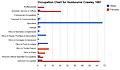 Occupation Chart for Husbourne Crawley 1881.jpg 673 × 390; 49 KB
-
 Occupation Chart for Husbourne Crawley 2011.jpg 805 × 484; 136 KB
-
 Old route of Ridgemont Road - geograph.org.uk - 3109885.jpg 1,600 × 1,067; 616 KB
-
 Ordnance Survey Cut Mark - geograph.org.uk - 3255430.jpg 3,264 × 2,448; 2.36 MB
-
 Ordnance Survey Cut Mark - geograph.org.uk - 3255436.jpg 3,264 × 2,448; 1.94 MB
-
 Path by the Dolphinarium - geograph.org.uk - 3519735.jpg 1,600 × 1,066; 709 KB
-
 Path by the hedge across the field - geograph.org.uk - 3117675.jpg 1,200 × 1,600; 653 KB
-
 Path through the Woburn estate - geograph.org.uk - 3519711.jpg 1,600 × 1,067; 745 KB
-
 Path through the woods - geograph.org.uk - 3519741.jpg 1,600 × 1,067; 766 KB
-
 Path to Birchmoor farm - geograph.org.uk - 3118809.jpg 1,600 × 1,068; 718 KB
-
 Path to Ridgmont station - geograph.org.uk - 3117670.jpg 1,600 × 1,068; 429 KB
-

-
 Rhino at Woburn - geograph.org.uk - 1834487.jpg 640 × 480; 73 KB
-
 Ridgmont Road - geograph.org.uk - 4729083.jpg 640 × 480; 70 KB
-

-
 School Lane - geograph.org.uk - 5510362.jpg 640 × 480; 77 KB
-
 School Lane, Husborne Crawley - geograph.org.uk - 4628332.jpg 640 × 480; 59 KB
-
 Sealite at Brogborough - geograph.org.uk - 5551587.jpg 3,264 × 2,448; 3.93 MB
-

-
 Slip off northbound M1, junction 13 - geograph.org.uk - 5622909.jpg 640 × 428; 87 KB
-
 Small bridge - geograph.org.uk - 1412892.jpg 640 × 480; 118 KB
-
 St James' church, Husborne Crawley - geograph.org.uk - 3222745.jpg 1,067 × 1,600; 419 KB
-
 St James' Church, Husborne Crawley - geograph.org.uk - 4628333.jpg 478 × 640; 87 KB
-
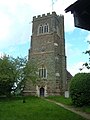 St. James Church, Husborne Crawley - geograph.org.uk - 1311067.jpg 480 × 640; 73 KB
-
 Station Road (A4012) - geograph.org.uk - 4628620.jpg 640 × 480; 69 KB
-
 Stile on the path to Church End - geograph.org.uk - 3109879.jpg 1,600 × 1,068; 674 KB
-
 Telephone box - geograph.org.uk - 1294280.jpg 480 × 640; 88 KB
-
 The M1 at Brogborough, Bedfordshire - geograph.org.uk - 2708352.jpg 1,600 × 1,200; 290 KB
-
 The White Horse - geograph.org.uk - 1311051.jpg 640 × 480; 61 KB
-
 The White Horse - geograph.org.uk - 5510361.jpg 640 × 480; 52 KB
-
 The White Horse, Husborne Crawley - geograph.org.uk - 4628326.jpg 640 × 446; 56 KB
-
 Two way signpost - geograph.org.uk - 1294288.jpg 640 × 480; 61 KB
-
 Woburn Safari Park - geograph.org.uk - 4628627.jpg 1,024 × 683; 316 KB
-
 Woburn Safari Park - geograph.org.uk - 4628636.jpg 1,024 × 683; 290 KB
-
 Woburn Safari Park, aerial 2015 - geograph.org.uk - 4527530.jpg 640 × 427; 58 KB
-
 Brogborough Gateway Trail - geograph.org.uk - 655787.jpg 640 × 480; 90 KB
-
 Brogborough Hill Picnic Site - geograph.org.uk - 430554.jpg 640 × 282; 41 KB
-
 Easy Life - geograph.org.uk - 655798.jpg 640 × 480; 97 KB
-
 Zip wire launch point - geograph.org.uk - 3519738.jpg 1,200 × 1,600; 798 KB
-
 The Old Chapel, Aspley Guise - geograph.org.uk - 217716.jpg 480 × 640; 61 KB
-
 The View from Brogborough Hill - geograph.org.uk - 430528.jpg 640 × 480; 70 KB
-
 The White Horse - geograph.org.uk - 147369.jpg 640 × 427; 62 KB
-
 Woburn Experimental Farm - geograph.org.uk - 147373.jpg 640 × 427; 78 KB


.jpg)
.jpg)
.jpg)
.jpg)
.jpg)


_-_geograph.org.uk_-_4628623.jpg)
_-_geograph.org.uk_-_4729224.jpg)


_-_geograph.org.uk_-_4628620.jpg)


