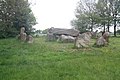
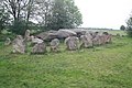
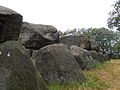
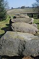
Category:Hunebed D50 in Noord-Sleen
Jump to navigation
Jump to search
| Object location | | View all coordinates using: OpenStreetMap |
|---|
dolmen in the Netherlands  | |||||
| Upload media | |||||
| Instance of | |||||
|---|---|---|---|---|---|
| Part of | |||||
| Location | Sleen, Sleen | ||||
| Street address |
| ||||
| Heritage designation |
| ||||
 | |||||
|
This is a category about rijksmonument number 46000
|
| Address |
|
Media in category "Hunebed D50 in Noord-Sleen"
The following 16 files are in this category, out of 16 total.
-
 Hunebed D50 - 1.JPG 4,272 × 2,848; 5.78 MB
-
 Hunebed D50 - 2.JPG 4,272 × 2,848; 6.18 MB
-
 Hunebed D50 - 3.JPG 4,272 × 2,848; 6.68 MB
-
 Hunebed D50 - 4.JPG 4,272 × 2,848; 5.87 MB
-
 Hunebed D50 - 5.JPG 4,272 × 2,848; 6.34 MB
-
 Hunebed D50 - 6.JPG 4,272 × 2,848; 5.9 MB
-
 Hunebed D50 - 7.JPG 4,272 × 2,848; 5.87 MB
-
 Hunebed D50 bij Noord-Sleen.jpg 1,296 × 972; 259 KB
-
 Hunebed D50 Noord-Sleen (4869081504).jpg 4,000 × 3,000; 2.8 MB
-
 Hunebed D50 Noord-Sleen (4869081990) (3).jpg 4,000 × 3,000; 2.79 MB
-
 Hunebed D50 Noord-Sleen (4869082742).jpg 4,000 × 3,000; 2.58 MB
-
 Hunebed D50 Noord-Sleen (4869083168).jpg 4,000 × 3,000; 2.64 MB
-
 Hunebed D50 Sleen.JPG 2,048 × 1,536; 1.03 MB
-
 Hunebed Noord Sleen.jpg 3,872 × 2,592; 4.91 MB
-
 HunebedD50.jpg 4,000 × 3,000; 5.72 MB
-
 Op het hunebed.jpg 2,592 × 3,872; 4.85 MB


.jpg)
_(3).jpg)
.jpg)
.jpg)


