Category:Hothfield
Jump to navigation
Jump to search
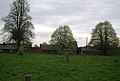
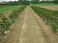
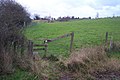
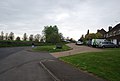
English: Hothfield is a village and civil parish in the Ashford District of Kent, England and is located north-west of Ashford town.
village in Kent, UK  | |||||
| Upload media | |||||
| Instance of | |||||
|---|---|---|---|---|---|
| Location | Ashford, Kent, South East England, England | ||||
| Area |
| ||||
| Said to be the same as | Hothfield (Wikimedia duplicated page, civil parish) | ||||
 | |||||
Subcategories
This category has the following 4 subcategories, out of 4 total.
H
- Hothfield Common (15 F)
M
- St Margaret's church, Hothfield (31 F)
O
- Oasts in Hothfield (4 F)
T
- Thanet Arms, Hothfield (3 F)
Media in category "Hothfield"
The following 200 files are in this category, out of 230 total.
(previous page) (next page)-
 A20 Bridge, M20 - geograph.org.uk - 4572827.jpg 640 × 434; 44 KB
-
 A20 Maidstone Road bridge - geograph.org.uk - 1430652.jpg 640 × 480; 45 KB
-
 Access road to Dean Court - geograph.org.uk - 1455917.jpg 640 × 480; 96 KB
-
 Access road to High Ridge - geograph.org.uk - 1605445.jpg 640 × 427; 84 KB
-
 Approach to Hothfield - geograph.org.uk - 1735915.jpg 640 × 427; 62 KB
-
 Bank from Hothfield flood relief scheme - geograph.org.uk - 1277912.jpg 640 × 480; 119 KB
-
 Bear's Lane - geograph.org.uk - 1605384.jpg 640 × 427; 89 KB
-
 Beefeater restaurant - geograph.org.uk - 5948769.jpg 1,920 × 1,080; 382 KB
-
 Benacre Lodge - geograph.org.uk - 1605449.jpg 640 × 427; 111 KB
-
 Bethersden Road - geograph.org.uk - 6023718.jpg 1,024 × 684; 301 KB
-
 Bethersden Road through Newlands Wood - geograph.org.uk - 3431620.jpg 1,024 × 652; 268 KB
-
 Beware of the Bull Dayglo - geograph.org.uk - 1458210.jpg 640 × 427; 108 KB
-
 Bluebells Children's Centre - geograph.org.uk - 2469895.jpg 640 × 396; 57 KB
-
 Boardwalk, Hothfield Bog - geograph.org.uk - 2469841.jpg 640 × 430; 125 KB
-
 Boardwalk, Hothfield Common - geograph.org.uk - 4757224.jpg 640 × 480; 230 KB
-
 Boardwalk, Hothfield Heathlands - geograph.org.uk - 2467238.jpg 640 × 430; 62 KB
-
 Broken Stile near Cowlees Alders - geograph.org.uk - 1325767.jpg 640 × 480; 169 KB
-
 Brownmill Spinney - geograph.org.uk - 1605505.jpg 640 × 427; 46 KB
-
 Buildings on Oaklands Farm - geograph.org.uk - 1278347.jpg 640 × 480; 103 KB
-
 Byway running north from Pluckley Road - geograph.org.uk - 6153771.jpg 1,024 × 768; 707 KB
-
 Channel Tunnel Rail Link - geograph.org.uk - 1502047.jpg 640 × 427; 88 KB
-

-
 Confluence of dry ditches. - geograph.org.uk - 408405.jpg 640 × 428; 403 KB
-
 CTRL heading to Ashford - geograph.org.uk - 1430700.jpg 640 × 480; 84 KB
-
 Dead tree near Swinford Manor School - geograph.org.uk - 1275004.jpg 480 × 640; 140 KB
-
 Dead tree near the Roundell - geograph.org.uk - 1601948.jpg 640 × 427; 68 KB
-
 Derelict outbuilding, Britton Farm - geograph.org.uk - 4816529.jpg 3,264 × 2,448; 3.85 MB
-
 Derelict outbuilding, Britton Farm - geograph.org.uk - 4816560.jpg 3,264 × 2,448; 2.73 MB
-
 Derelict outbuildings, Britton Farm - geograph.org.uk - 4816522.jpg 3,264 × 2,448; 3.69 MB
-
 Derelict outbuildings, Britton Farm - geograph.org.uk - 4816549.jpg 3,264 × 2,448; 3.96 MB
-
 Derelict outbuildings, Britton Farm - geograph.org.uk - 4816572.jpg 3,264 × 2,448; 3.94 MB
-
 Derelict stable block, Britton House - geograph.org.uk - 4817438.jpg 3,264 × 2,376; 2.55 MB
-
 Dilapidated farm building - geograph.org.uk - 3323853.jpg 1,077 × 807; 182 KB
-
 Dilapidated farm building, Godinton Lane - geograph.org.uk - 4475178.jpg 3,264 × 2,448; 2.78 MB
-

-
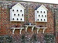 Dovecotts - geograph.org.uk - 354573.jpg 448 × 336; 45 KB
-
 Dunn Street Farmhouse - geograph.org.uk - 1409479.jpg 640 × 480; 266 KB
-
 Egg Hole on the Stour Valley Walk - geograph.org.uk - 1605488.jpg 640 × 427; 131 KB
-
 Entering Hothfield on West Street - geograph.org.uk - 1282692.jpg 640 × 480; 135 KB
-
 Entrance to Goldwyn Community Special School - geograph.org.uk - 3323824.jpg 1,077 × 807; 222 KB
-
 Esso filling station at Ram Lane - geograph.org.uk - 5948768.jpg 1,920 × 1,080; 408 KB
-
 Esso filling station, Tutt Hill - geograph.org.uk - 408372.jpg 640 × 428; 300 KB
-
 Farmland near Hall Farm - geograph.org.uk - 1280502.jpg 640 × 480; 134 KB
-
 Farmland south of the railway - geograph.org.uk - 2955731.jpg 640 × 430; 31 KB
-
 Field - geograph.org.uk - 5448796.jpg 640 × 426; 24 KB
-
 Field and railway - geograph.org.uk - 202403.jpg 640 × 405; 49 KB
-
 Field and trees west of byway - geograph.org.uk - 6153672.jpg 1,024 × 768; 424 KB
-
 Footbridge on the Greensand Way - geograph.org.uk - 1601970.jpg 640 × 427; 81 KB
-
 Footbridge over a small stream - geograph.org.uk - 2472483.jpg 640 × 430; 92 KB
-
-

-
 Footpath to Hothfield Church - geograph.org.uk - 2472458.jpg 640 × 430; 78 KB
-
 Former Hothfield Post Office Stores - geograph.org.uk - 1735910.jpg 640 × 480; 70 KB
-

-
 Fruit bushes - geograph.org.uk - 2467157.jpg 640 × 430; 61 KB
-
 Gate onto Hothfield Common - geograph.org.uk - 3423766.jpg 2,048 × 1,536; 1.58 MB
-
 Godinton Lane - geograph.org.uk - 6026820.jpg 1,024 × 684; 293 KB
-
 Gorse, Hothfield Heathlands - geograph.org.uk - 2467221.jpg 640 × 430; 70 KB
-
 Grass farm track to Home Farm - geograph.org.uk - 1601935.jpg 640 × 427; 86 KB
-
 Great Chart Golf Course - geograph.org.uk - 403418.jpg 640 × 461; 174 KB
-
 Great Stour River, Worten - geograph.org.uk - 403370.jpg 640 × 475; 176 KB
-
 Greensand Way by Waterfall Rd - geograph.org.uk - 2472504.jpg 640 × 430; 63 KB
-
 Greensand Way crosses The Street - geograph.org.uk - 2472454.jpg 640 × 430; 99 KB
-

-

-
-
 Greensand Way, Hothfield Heathlands - geograph.org.uk - 2467152.jpg 640 × 430; 89 KB
-
 Greensand Way, Hothfield Heathlands - geograph.org.uk - 2467175.jpg 640 × 430; 90 KB
-
 Greensand Way, Hothfield Heathlands - geograph.org.uk - 2467212.jpg 640 × 430; 65 KB
-
 Greensand Way, Hothfield Heathlands - geograph.org.uk - 2467286.jpg 640 × 430; 123 KB
-
 Hall Farm Cottages - geograph.org.uk - 1282639.jpg 640 × 480; 132 KB
-
 Hare ^ Hounds, Potters Corner - geograph.org.uk - 2077055.jpg 3,365 × 2,524; 2 MB
-
 Horses, Hothfield Heathlands - geograph.org.uk - 2467145.jpg 640 × 400; 71 KB
-
 Hothfield 'Waterfall' - geograph.org.uk - 1505847.jpg 427 × 640; 117 KB
-
 Hothfield Bog - geograph.org.uk - 2467266.jpg 640 × 430; 104 KB
-
 Hothfield Bog - geograph.org.uk - 2467272.jpg 640 × 430; 113 KB
-
 Hothfield Bog - geograph.org.uk - 2469850.jpg 640 × 430; 126 KB
-
 Hothfield Bog - geograph.org.uk - 2469856.jpg 640 × 430; 116 KB
-
 Hothfield Common - 1981 - geograph.org.uk - 2757849.jpg 2,272 × 1,521; 602 KB
-
 Hothfield Common - 1981 - geograph.org.uk - 2757850.jpg 2,272 × 1,521; 988 KB
-
 Hothfield Common - 1981 - geograph.org.uk - 2757852.jpg 2,272 × 1,521; 639 KB
-
 Hothfield Common - 1981 - geograph.org.uk - 2757858.jpg 2,272 × 1,521; 754 KB
-
 Hothfield Common - 1981 - geograph.org.uk - 2757859.jpg 2,272 × 1,521; 656 KB
-
 Hothfield Halt site geograph-3693040-by-Ben-Brooksbank.jpg 2,352 × 1,390; 2.42 MB
-

-
 Hothfield Heathlands - geograph.org.uk - 1092153.jpg 640 × 480; 81 KB
-
 Hothfield Heathlands - geograph.org.uk - 2467180.jpg 640 × 430; 48 KB
-
 Hothfield Heathlands - geograph.org.uk - 2467194.jpg 640 × 430; 105 KB
-
 Hothfield Heathlands - geograph.org.uk - 2467200.jpg 640 × 430; 83 KB
-
 Hothfield Heathlands - geograph.org.uk - 2467206.jpg 640 × 430; 54 KB
-
 Hothfield Heathlands - geograph.org.uk - 2467215.jpg 640 × 430; 107 KB
-
 Hothfield Heathlands - geograph.org.uk - 2467243.jpg 640 × 430; 59 KB
-
 Hothfield Heathlands - geograph.org.uk - 2467247.jpg 640 × 430; 66 KB
-
 Hothfield Heathlands - geograph.org.uk - 2467257.jpg 640 × 430; 63 KB
-
 Hothfield Heathlands - geograph.org.uk - 2469833.jpg 640 × 430; 81 KB
-
 Hothfield Post Office Stores, The Street - geograph.org.uk - 1282717.jpg 640 × 480; 126 KB
-
 Hothfield primary school, School Road - geograph.org.uk - 1282830.jpg 640 × 480; 137 KB
-
 Hothfield Village Sign - geograph.org.uk - 2469900.jpg 640 × 430; 41 KB
-
 Houses on School Rd, Hothfield - geograph.org.uk - 2469885.jpg 640 × 430; 46 KB
-
 Hurst Hill Farm Cottages - geograph.org.uk - 1278360.jpg 640 × 480; 152 KB
-

-
 Job's Lane through Benacre Wood - geograph.org.uk - 1605453.jpg 640 × 427; 108 KB
-

-

-

-
 Junction on Bethersden Road - geograph.org.uk - 1605390.jpg 640 × 427; 51 KB
-
 Junction on the Pluckley Road - geograph.org.uk - 1278342.jpg 640 × 480; 130 KB
-
 Kissing Gate in Foxenhill Toll - geograph.org.uk - 1601792.jpg 640 × 427; 123 KB
-
 Kissing gate on Waterfall Road - geograph.org.uk - 1601983.jpg 640 × 427; 115 KB
-
 Kissing gate, Greensand Way - geograph.org.uk - 2467189.jpg 640 × 430; 135 KB
-
 Lane near Swinford Manor School - geograph.org.uk - 1275534.jpg 480 × 640; 163 KB
-

-

-
 Looking NE along the Stour Valley Walk - geograph.org.uk - 1280492.jpg 640 × 480; 187 KB
-
 Looking north along Godinton Lane - geograph.org.uk - 3323875.jpg 1,077 × 807; 144 KB
-

-
 Looking W along the Stour Valley Walk - geograph.org.uk - 1278300.jpg 640 × 480; 133 KB
-
 M20 bridge carries A20 - geograph.org.uk - 2578234.jpg 3,648 × 2,736; 1.32 MB
-
 Maidstone Road, Hothfield - geograph.org.uk - 4906240.jpg 2,048 × 1,536; 946 KB
-
 March Wood - geograph.org.uk - 2948848.jpg 640 × 430; 113 KB
-
 Mitchell Farm - geograph.org.uk - 1601876.jpg 640 × 427; 98 KB
-
 Mitchell Farm from West Street - geograph.org.uk - 1282668.jpg 640 × 480; 145 KB
-
 Newland Wood - geograph.org.uk - 2948853.jpg 640 × 430; 112 KB
-
 Newland Wood - geograph.org.uk - 2948859.jpg 640 × 430; 100 KB
-
 Oak Tree and field ditch - geograph.org.uk - 1605499.jpg 640 × 427; 108 KB
-
 Oak Tree on the Stour Valley Walk - geograph.org.uk - 1605493.jpg 640 × 427; 94 KB
-
 One alive, one dead - geograph.org.uk - 2472486.jpg 640 × 430; 72 KB
-
 Outbuildings, Hothfield Manor - geograph.org.uk - 2472459.jpg 640 × 430; 68 KB
-
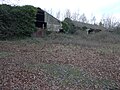
 Overgrown WWII Bunker - geograph.org.uk - 1505838.jpg 640 × 519; 118 KB
-
 Park Drive - geograph.org.uk - 1735927.jpg 640 × 480; 75 KB
-
 Park Drive, Hothfield - geograph.org.uk - 2470090.jpg 640 × 430; 71 KB
-
 Park Drive, Hothfield - geograph.org.uk - 2470096.jpg 640 × 430; 77 KB
-
 Parking area on the A20 near Tutt Hill - geograph.org.uk - 3423752.jpg 2,048 × 1,536; 1.58 MB
-
 Parkland, Hothfield - geograph.org.uk - 2472474.jpg 640 × 430; 49 KB
-
 Parkland, Hothfield - geograph.org.uk - 2472478.jpg 640 × 430; 51 KB
-

-
 Pillbox covered in Ivy - geograph.org.uk - 2472501.jpg 640 × 430; 121 KB
-
 Pluckley Road - geograph.org.uk - 1735990.jpg 640 × 480; 142 KB
-
 Pluckley Road - geograph.org.uk - 6026857.jpg 1,024 × 684; 417 KB
-
 Pluckley Road - geograph.org.uk - 6153775.jpg 1,024 × 768; 644 KB
-
 Pond by byway - geograph.org.uk - 6153347.jpg 1,024 × 768; 741 KB
-
 Pond near the Stour Valley Walk - geograph.org.uk - 1280007.jpg 640 × 480; 244 KB
-
 Post Office, Hothfield - geograph.org.uk - 2470066.jpg 640 × 430; 60 KB
-
 Rainbow over Hothfield Common - geograph.org.uk - 1601814.jpg 640 × 427; 39 KB
-
 Red brick house, The Street - geograph.org.uk - 2472451.jpg 640 × 430; 47 KB
-
 Ripper's Cross Farm - geograph.org.uk - 1278322.jpg 640 × 480; 118 KB
-

-
 River Great Stour at Ripper's Cross - geograph.org.uk - 2210586.jpg 1,106 × 745; 543 KB
-
 Road sign, Waterfall Rd - geograph.org.uk - 2472499.jpg 640 × 430; 124 KB
-
 Rough grazing, Hothfield - geograph.org.uk - 2472481.jpg 640 × 430; 43 KB
-
 Route of the Stour Valley Walk - geograph.org.uk - 1278361.jpg 640 × 480; 185 KB
-
 Row of cottages, Hothfield - geograph.org.uk - 2472452.jpg 640 × 430; 64 KB
-
 Row of Monkey Puzzle Trees - geograph.org.uk - 1325763.jpg 640 × 480; 103 KB
-
 School Rd, Hothfield - geograph.org.uk - 2469882.jpg 640 × 430; 57 KB
-
 Sheep grazing - geograph.org.uk - 2472468.jpg 640 × 430; 58 KB
-
 Sheep grazing by a tree - geograph.org.uk - 2472461.jpg 640 × 430; 42 KB
-
 Sheep grazing, Hothfield - geograph.org.uk - 2472469.jpg 640 × 430; 48 KB
-
 Sheep, Hothfield - geograph.org.uk - 2472470.jpg 640 × 430; 46 KB
-
 Sheep, Hothfield - geograph.org.uk - 2472487.jpg 640 × 430; 76 KB
-
 Small pond to the N of West Street - geograph.org.uk - 1282684.jpg 640 × 480; 173 KB
-
 Small reservoir on hill - geograph.org.uk - 6153359.jpg 1,024 × 768; 257 KB
-
 Small stream near Hothfield - geograph.org.uk - 2472484.jpg 640 × 430; 98 KB
-
 Small stream, Hothfield - geograph.org.uk - 2472485.jpg 640 × 430; 101 KB
-
 Stile in Worten Wood - geograph.org.uk - 1605364.jpg 640 × 427; 130 KB
-
 Stile into Worten Wood - geograph.org.uk - 1605366.jpg 640 × 427; 122 KB
-
 Stile near Mansion Copse - geograph.org.uk - 1601954.jpg 640 × 427; 93 KB
-
 Stile on Greensand Way near Turners - geograph.org.uk - 1601866.jpg 640 × 427; 84 KB
-

-
 Stile opposite Benacre Wood - geograph.org.uk - 1605462.jpg 640 × 427; 101 KB
-
 Stile to sheep field - geograph.org.uk - 1605467.jpg 640 × 427; 78 KB
-
 Stile, Greensand Way - geograph.org.uk - 2467305.jpg 640 × 430; 108 KB
-
 Stour Valley Walk past Hall Farm - geograph.org.uk - 1282628.jpg 640 × 480; 156 KB
-
 Stream crossing a field - geograph.org.uk - 4944064.jpg 640 × 426; 48 KB
-
 Thanet House, Hothfield - geograph.org.uk - 2472455.jpg 640 × 430; 74 KB
-
 The A20 passes Yonsea Farm in 1987 - geograph.org.uk - 1885846.jpg 800 × 568; 82 KB
-
 The Greensand Way (indistinct) - geograph.org.uk - 2472479.jpg 640 × 430; 52 KB
-
 The Greensand Way - geograph.org.uk - 2472472.jpg 640 × 430; 81 KB
-

-

-
 The Greensand Way enters Godinton Estate - geograph.org.uk - 1601998.jpg 427 × 640; 116 KB
-

-
 The Greensand Way near Mitchell Farm - geograph.org.uk - 1601892.jpg 640 × 427; 89 KB
-
 The Greensand Way towards Turners - geograph.org.uk - 1605516.jpg 640 × 427; 83 KB
-
 The Hop Pickers, Hothfield - geograph.org.uk - 2077074.jpg 2,397 × 1,536; 877 KB
-
 The Roundel - geograph.org.uk - 2472476.jpg 640 × 430; 47 KB
-

-

-
 The Street, Hothfield - geograph.org.uk - 2469956.jpg 640 × 430; 90 KB
-
 The Street, Hothfield - geograph.org.uk - 2470103.jpg 640 × 430; 75 KB
-
 The Street, Hothfield - geograph.org.uk - 2470110.jpg 640 × 430; 48 KB
-
 The Woolpack - geograph.org.uk - 1325770.jpg 640 × 480; 64 KB
-
 The Yellow Fisherman - geograph.org.uk - 408355.jpg 640 × 428; 299 KB
-
 Track across parkland - geograph.org.uk - 2472475.jpg 640 × 430; 42 KB
-
 Track into Newlands Wood - geograph.org.uk - 4757464.jpg 640 × 480; 253 KB
-
 Tree management in Hothfield Common - geograph.org.uk - 1600927.jpg 640 × 427; 98 KB
-
 Trees by Ram Lane - geograph.org.uk - 4757252.jpg 640 × 480; 157 KB
-
 Trot Path - geograph.org.uk - 1601808.jpg 427 × 640; 109 KB
-
 Tufton Drive, Hothfield - geograph.org.uk - 2469962.jpg 640 × 430; 79 KB
-
 Turners on West Street, near Hothfield - geograph.org.uk - 1282675.jpg 640 × 480; 138 KB
-
 Unused stile on Greensand Way - geograph.org.uk - 1601920.jpg 640 × 427; 66 KB


_-_geograph.org.uk_-_2472479.jpg)


