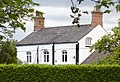
Category:Home Farmhouse, Ashton-in-Makerfield
Jump to navigation
Jump to search
| Object location | | View all coordinates using: OpenStreetMap |
|---|
grade II listed farmhouse in Ashton-in-Makerfield, Wigan, Greater Manchester, UK  | |||||
| Upload media | |||||
| Instance of | |||||
|---|---|---|---|---|---|
| Location | Wigan, Greater Manchester, North West England, England | ||||
| Heritage designation |
| ||||
 | |||||
Media in category "Home Farmhouse, Ashton-in-Makerfield"
The following 2 files are in this category, out of 2 total.
-
 Home Farmhouse, Ashton-in-Makerfield 1.jpg 4,842 × 3,289; 18.01 MB
-
 Home Farmhouse, Ashton-in-Makerfield 2.jpg 5,046 × 3,277; 19.1 MB
