Category:Hohle Gasse
Jump to navigation
Jump to search
| Object location | | View all coordinates using: OpenStreetMap |
|---|
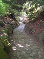
sunken path between Küssnacht and Immensee in the municipality of Küssnacht in the canton of Schwyz, Switzerland   | |||||
| Upload media | |||||
| Instance of | |||||
|---|---|---|---|---|---|
| Part of |
| ||||
| Location | Immensee, Küssnacht, Küssnacht District, Schwyz, Switzerland | ||||
 | |||||
Media in category "Hohle Gasse"
The following 28 files are in this category, out of 28 total.
-
 ETH-BIB-Hohle Gasse, Küsnacht -Küssnacht, ZH--Dia 247-12573.tif 2,986 × 3,399; 29.21 MB
-
 ETH-BIB-Hohle Gasse, Küsnacht -Küssnacht, ZH--Dia 247-12574.tif 2,986 × 3,381; 29.03 MB
-
 Fotografi från Hohle Gasse - Hallwylska museet - 104442.tif 3,414 × 4,540; 44.38 MB
-
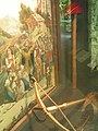
 Gessler's tod.jpg 4,294 × 3,885; 19.78 MB
-
 Hohle Gasse - Alte Schuljugendtafel.jpg 2,272 × 1,704; 688 KB
-
 Hohle Gasse - Neue Schuljugendtafel.jpg 2,272 × 1,704; 774 KB
-
 Hohle Gasse - Tonbildschau01.jpg 2,272 × 1,704; 692 KB
-
 Hohle Gasse - Tonbildschau02.jpg 1,704 × 2,272; 766 KB
-
 Hohle Gasse Immensee.jpg 3,024 × 4,032; 6.14 MB
-
 Hohle Gasse, Küssnacht.jpg 1,536 × 2,048; 1.42 MB
-
 Hohle Gasse, Schweiz.jpg 2,360 × 3,525; 7.15 MB
-
 Hohle gasse01.jpg 2,304 × 1,728; 2.94 MB
-
 Hohle gasse02.jpg 1,728 × 2,304; 4.46 MB
-
 Hohle gasse03.jpg 1,767 × 1,416; 3.76 MB
-
 Hohle gasse04.jpg 1,704 × 2,272; 750 KB
-
 Immensee-Hohle Gasse-Memorial renovation Hohle Gasse-01ASD.jpg 3,468 × 4,624; 6.81 MB
-
 Immensee-Hohle Gasse-Wilhem Tell chapel-02ESD.jpg 3,456 × 4,608; 1.73 MB
-
 Immensee-Hohle Gasse-Wilhem Tell chapel-99ASD.jpg 4,624 × 3,468; 6.91 MB
-
 Immensee-Hohle Gasse-Wilhem Tell chapel-open air stage-toiletts-01ASD.jpg 4,624 × 3,468; 7.45 MB
-
 Immensee-Hohle Gasse-Wilhem Tell-Hermann Gessler-01ASD.jpg 3,468 × 4,624; 2.58 MB
-
 Immensee-Hohle Gasse-Wilhem Tell-Hermann Gessler-02ASD.jpg 3,468 × 4,624; 3.23 MB
-
 Immensee-Hohle Gasse-Wilhem Tell-Hermann Gessler-03ASD.jpg 3,468 × 4,624; 2.77 MB
-
 Immensee-Hohle Gasse-Wilhem Tell-Hermann Gessler-04ASD.jpg 3,468 × 4,624; 2.36 MB
-
 Immensee-Hohle Gasse-Wilhem Tell-Hermann Gessler-05ASD.jpg 3,468 × 4,624; 2.82 MB
-
 Immensee-Hohle Gasse-Wilhem Tell-Hermann Gessler-06ASD.jpg 3,468 × 4,624; 1.9 MB
-
 Immensee-Hohle Gasse-Wilhem Tell-Hermann Gessler-chapel-07ASD.jpg 3,468 × 4,624; 3.68 MB
-
 Immensee-Hohle Gasse-Wilhem Tell-Hermann Gessler-chapel-08ESD.jpg 3,456 × 4,608; 2.5 MB
-
 Immensee-Hohle Gasse-Wilhem Tell-Hermann Gessler-chapel-sign post-01ASD.jpg 3,468 × 4,624; 3 MB


