Category:Hoge Enk
Jump to navigation
Jump to search
| Object location | | View all coordinates using: OpenStreetMap |
|---|
village in Elburg, Netherlands   | |||||
| Upload media | |||||
| Spoken text audio | |||||
|---|---|---|---|---|---|
| Instance of | |||||
| Location | Elburg, Gelderland, Netherlands | ||||
 | |||||
Subcategories
This category has only the following subcategory.
G
Media in category "Hoge Enk"
The following 51 files are in this category, out of 51 total.
-
 Map - NL - Elburg - Wijk 03 Doornspijk - Buurt 04 Hoge Enk.svg 375 × 375; 19 KB
-
Nl-Hoge Enk-article.ogg 1 min 9 s; 677 KB
-
 Achter- en zijgevel nr. LH149-1 - Hoge Enk - 20473219 - RCE.jpg 1,200 × 900; 182 KB
-
 Achtergevel nr. D11-A - Hoge Enk - 20473201 - RCE.jpg 1,200 × 900; 150 KB
-
 Achtergevel nr. D16-A - Hoge Enk - 20473216 - RCE.jpg 1,200 × 900; 115 KB
-
 Achtergevel nr. D17-A - Hoge Enk - 20473217 - RCE.jpg 1,200 × 900; 154 KB
-
 Achtergevel nr. D55-A - Hoge Enk - 20473281 - RCE.jpg 1,200 × 900; 110 KB
-
 Achtergevel nr. D58-A - Hoge Enk - 20473291 - RCE.jpg 1,200 × 900; 148 KB
-
 Achtergevel nr. D59-C - Hoge Enk - 20473296 - RCE.jpg 1,200 × 900; 128 KB
-
 Achterzijde tijdens afbraak nr. D59-E - Hoge Enk - 20473297 - RCE.jpg 1,200 × 900; 149 KB
-
 Achterzijde tijdens afbraak nr. D59-F - Hoge Enk - 20473295 - RCE.jpg 1,200 × 900; 107 KB
-
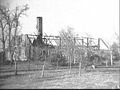 Boerderij na brand nov. 1974 nr. D57-B - Hoge Enk - 20473285 - RCE.jpg 1,200 × 900; 145 KB
-
 Drie woningen nr. LH151-12 - Hoge Enk - 20486186 - RCE.jpg 1,200 × 900; 201 KB
-

-
 Vier boerderijen nr. LH148-4 - Hoge Enk - 20482247 - RCE.jpg 1,200 × 900; 210 KB
-
 Vier boerderijen nr. LH148-5 - Hoge Enk - 20482248 - RCE.jpg 1,200 × 900; 210 KB
-

-
 Voor- en zijgevel (woning) nr. LH148-2 - Hoge Enk - 20482245 - RCE.jpg 1,200 × 900; 175 KB
-
 Voor- en zijgevel - Hoge Enk - 20465667 - RCE.jpg 1,200 × 900; 189 KB
-
 Voor- en zijgevel nr. D12-A - Hoge Enk - 20473203 - RCE.jpg 1,200 × 900; 131 KB
-
 Voor- en zijgevel nr. D22-A - Hoge Enk - 20473228 - RCE.jpg 1,200 × 900; 156 KB
-
 Voor- en zijgevel nr. D26-A - Hoge Enk - 20473233 - RCE.jpg 1,200 × 900; 178 KB
-
 Voor- en zijgevel nr. D54-A - Hoge Enk - 20473279 - RCE.jpg 1,200 × 900; 135 KB
-
 Voor- en zijgevel nr. LH148-11 - Hoge Enk - 20473282 - RCE.jpg 1,200 × 900; 187 KB
-
 Voor- en zijgevel nr. LH149-4 - Hoge Enk - 20486131 - RCE.jpg 1,200 × 900; 195 KB
-
 Voor- en zijgevel nr. LH151-6 - Hoge Enk - 20486165 - RCE.jpg 1,200 × 900; 192 KB
-
 Voor- en zijgevel nr. LH151-7 - Hoge Enk - 20486166 - RCE.jpg 1,200 × 900; 204 KB
-
 Voorgevel (linkse boerderij) nr. LH148-7 - Hoge Enk - 20473280 - RCE.jpg 1,200 × 900; 205 KB
-

-
 Voorgevel nr. D57-A - Hoge Enk - 20473286 - RCE.jpg 1,200 × 900; 189 KB
-
 Voorgevel nr. D58-B - Hoge Enk - 20473290 - RCE.jpg 1,200 × 900; 227 KB
-
 Voorgevel nr. D58-C - Hoge Enk - 20473289 - RCE.jpg 1,200 × 900; 117 KB
-
 Voorgevel nr. D59-A - Hoge Enk - 20473292 - RCE.jpg 1,200 × 900; 204 KB
-
 Voorgevel nr. D59-B - Hoge Enk - 20473293 - RCE.jpg 1,200 × 900; 176 KB
-
 Voorgevel nr. LH148-12 - Hoge Enk - 20486128 - RCE.jpg 1,200 × 900; 164 KB
-
 Voorgevel nr. LH148-16 - Hoge Enk - 20486130 - RCE.jpg 1,200 × 900; 175 KB
-
 Voorgevel nr. LH150-11 - Hoge Enk - 20486158 - RCE.jpg 1,200 × 900; 198 KB
-
 Voorgevel nr. LH150-7 - Hoge Enk - 20486157 - RCE.jpg 1,200 × 900; 202 KB
-
 Voorgevel tijdens afbraak nr. D59-D - Hoge Enk - 20473294 - RCE.jpg 1,200 × 900; 163 KB
-
 Voorgevels nr. LH151-14 - Hoge Enk - 20486187 - RCE.jpg 1,200 × 900; 187 KB
-

-
 Zij- en achtergevel nr. D19-A - Hoge Enk - 20473220 - RCE.jpg 1,200 × 900; 144 KB
-
 Zij- en achtergevel nr. D9-A - Hoge Enk - 20473197 - RCE.jpg 1,200 × 900; 130 KB
-
 Zij- en kopgevel - Hoge Enk - 20465666 - RCE.jpg 1,200 × 900; 177 KB
-
 Zij- en voorgevel (woning) nr. LH152-1 - Hoge Enk - 20486190 - RCE.jpg 1,200 × 900; 190 KB
-
 Zij- en voorgevel nr. D14-A - Hoge Enk - 20473208 - RCE.jpg 1,200 × 900; 156 KB
-
 Zij- en voorgevel nr. LH148-10 - Hoge Enk - 20473202 - RCE.jpg 1,200 × 900; 181 KB
-
 Zij- en voorgevel nr. LH148-3 - Hoge Enk - 20482246 - RCE.jpg 1,200 × 900; 168 KB
-
 Zij- en voorgevel nr. LH151-5 - Hoge Enk - 20486164 - RCE.jpg 1,200 × 900; 189 KB
-
 Zij- en voorgevels nr. LH150-12 - Hoge Enk - 20486159 - RCE.jpg 1,200 × 900; 192 KB
-
 Zijgevel naam boerderij in dak nr. LH151-16 - Hoge Enk - 20486189 - RCE.jpg 1,200 × 900; 215 KB


_nr._LH_150-14_-_Hoge_Enk_-_20473284_-_RCE.jpg)
_nr._LH148-2_-_Hoge_Enk_-_20482245_-_RCE.jpg)


_nr._LH148-7_-_Hoge_Enk_-_20473280_-_RCE.jpg)
_nr._LH148-15_-_Hoge_Enk_-_20486129_-_RCE.jpg)


_nr._LH151-15_-_Hoge_Enk_-_20486188_-_RCE.jpg)


_nr._LH152-1_-_Hoge_Enk_-_20486190_-_RCE.jpg)


