Category:Heywood's Bank, Liverpool
Jump to navigation
Jump to search
| Object location | | View all coordinates using: OpenStreetMap |
|---|
Liverpool, Merseyside, L2  | |||||
| Upload media | |||||
| Instance of | |||||
|---|---|---|---|---|---|
| Location | Liverpool, Merseyside, North West England, England | ||||
| Heritage designation |
| ||||
 | |||||
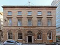
This is a category about listed building number 1356279. |
Grade II listed, built 1800 for Arthur Heywood and Sons Ltd Bank, later became a branch of Barclays. Ground floor now a restaurant
Media in category "Heywood's Bank, Liverpool"
The following 4 files are in this category, out of 4 total.
-
 Heywood Bank, Liverpool, 1787.jpg 588 × 360; 73 KB
-
 Heywood's Bank, Liverpool.jpg 453 × 640; 154 KB
-
 Heywoods Bank, Brunswick Street.jpg 4,388 × 3,277; 9.19 MB
-
 Key to Heywood's Bank, Brunswick Street, Liverpool.jpg 600 × 800; 34 KB


