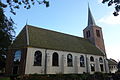
Category:Hervormde kerk Westerblokker
Jump to navigation
Jump to search
| Object location | | View all coordinates using: OpenStreetMap |
|---|
church in Blokker, Netherlands  | |||||
| Upload media | |||||
| Instance of | |||||
|---|---|---|---|---|---|
| Location | Blokker, Hoorn, North Holland, Netherlands | ||||
| Street address |
| ||||
| Has part(s) | |||||
| Heritage designation |
| ||||
 | |||||
Kerk
|
This is a category about rijksmonument number 22616
|
Toren
|
This is a category about rijksmonument number 22617
|
| Address |
|
Media in category "Hervormde kerk Westerblokker"
The following 50 files are in this category, out of 50 total.
-
 Ambtsdragersbank Hervormde kerk Westerblokker.jpg 2,592 × 3,888; 2.45 MB
-
 Atlas Schoemaker-WESTFRIESLAND-DEEL4-1239-Noord-Holland, Westerblokker.jpeg 1,038 × 1,688; 397 KB
-
 Baarhuisje hervormde kerk Westerblokker.JPG 3,888 × 2,592; 5.1 MB
-
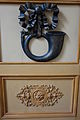 Deurtje doophek hervormde kerk Westerblokker 01.JPG 2,592 × 3,888; 2.5 MB
-
 Dichtgemetselde doorgang kerktoren Westerblokker.JPG 2,592 × 3,888; 2.42 MB
-
 Doophek Hervormde kerk Westerblokker.JPG 3,888 × 2,592; 3.4 MB
-
 Dooptuin - Westerblokker - 20253997 - RCE.jpg 1,200 × 960; 160 KB
-
 Exterieur - Blokker - 20036337 - RCE.jpg 1,200 × 970; 304 KB
-
 Ingang van de Hervormde kerk, Westerblokker.JPG 2,592 × 3,888; 4.5 MB
-
 Interieur naar het oosten - Westerblokker - 20253995 - RCE.jpg 1,200 × 945; 179 KB
-
 Interieur naar het westen - Westerblokker - 20253996 - RCE.jpg 1,200 × 954; 164 KB
-
 Interieur, aanzicht orgel, orgelnummer 1639 - Hoorn - 20369439 - RCE.jpg 956 × 1,200; 196 KB
-
 Kerk plus Toren Westerblokker.JPG 480 × 640; 94 KB
-
 Kerk Westerblokker.JPG 640 × 480; 79 KB
-
 Kistje hervormde kerk Westerblokker.JPG 3,888 × 2,592; 3.79 MB
-
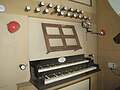 Klaviatuur van het Ypma-orgel.jpg 3,264 × 2,448; 4.26 MB
-
 Klokkenstoel hervormde kerk Westerblokker.JPG 2,592 × 3,888; 2.64 MB
-
 Kop luidas hervormde kerk Westerblokker.JPG 3,888 × 2,592; 3.28 MB
-
 Kroonluchter Hervormde kerk Westerblokker.JPG 2,592 × 3,888; 2.28 MB
-
 Lerarenlijst Hervormde kerk Westerblokker.JPG 2,592 × 3,888; 3.01 MB
-
 Linker paneel koorhek Hervormde kerk Westerblokker.JPG 3,888 × 2,592; 3.57 MB
-
 Luidklok Hervormde kerk Westerblokker.JPG 2,592 × 3,888; 3.09 MB
-
 Mechanisch uurwerk hervormde kerk Westerblokker.JPG 2,592 × 3,888; 2.76 MB
-
 Nonnengraf Westerblokker.JPG 3,888 × 2,592; 5.69 MB
-
 Noord-zijde - Westerblokker - 20253989 - RCE.jpg 1,200 × 809; 364 KB
-
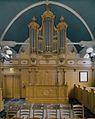
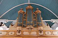 Orgel Hervormde kerk Westerblokker.JPG 3,888 × 2,592; 3.7 MB
-
 Overzicht zuidzijde - Westerblokker - 20253991 - RCE.jpg 1,200 × 952; 207 KB
-
 Panelen preekstoel hervormde kerk Westerblokker.JPG 2,592 × 3,888; 3.97 MB
-
 Pijpen kerkorgel Hervormde kerk Westerblokker.JPG 2,592 × 3,888; 3.08 MB
-
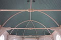
 Plafon kerktoren Westerblokker.JPG 3,888 × 2,592; 3.71 MB
-
 Poort van de Hervormde kerk, Westerblokker.JPG 3,888 × 2,592; 6.36 MB
-
 Preekstoel - Westerblokker - 20253986 - RCE.jpg 928 × 1,200; 315 KB
-
 Preekstoel - Westerblokker - 20253987 - RCE.jpg 937 × 1,200; 194 KB
-
 Preekstoel - Westerblokker - 20253998 - RCE.jpg 954 × 1,200; 174 KB
-
 Preekstoel Hervormde kerk Westerblokker.JPG 2,592 × 3,888; 2.61 MB
-
 Raam toren hervormde kerk Westerblokker.JPG 2,592 × 3,888; 2.65 MB
-
 Rechter paneel koorhek Hervormde kerk Westerblokker.JPG 3,888 × 2,592; 3.54 MB
-
 Roosters hervormde kerk Westerblokker.JPG 3,888 × 2,592; 2.64 MB
-
 Toetsen orgel hervormde kerk Westerblokker.jpg 1,632 × 916; 352 KB
-
 Tongewelf hervormde kerk Westerblokker.JPG 3,888 × 2,592; 3.01 MB
-
 Toren hervormde kerk Westerblokker.JPG 2,592 × 3,888; 3.24 MB
-
 Toren west-zijde - Westerblokker - 20253988 - RCE.jpg 812 × 1,200; 206 KB
-
 Toren westgevel - Westerblokker - 20253990 - RCE.jpg 951 × 1,200; 311 KB
-
 Westerblokker kerk.jpg 988 × 1,456; 388 KB
-
 Westerblokker kerktoren.jpg 896 × 1,474; 282 KB
-
 Zuid-west gevel - Westerblokker - 20253993 - RCE.jpg 955 × 1,200; 276 KB
-
 Zuidelijke gevel hervormde kerk Westerblokker.JPG 3,888 × 2,592; 3.64 MB
-
 Zuidgevel - Westerblokker - 20253992 - RCE.jpg 1,200 × 955; 333 KB
-
 Zuidgevel - Westerblokker - 20253994 - RCE.jpg 1,200 × 960; 339 KB
-
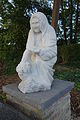 Zuster op nonnengraf.JPG 2,592 × 3,888; 3.21 MB


