Category:Hervormde kerk (Oud-Zuilen)
Jump to navigation
Jump to search
| Object location | | View all coordinates using: OpenStreetMap |
|---|
church building in Stichtse Vecht, Netherlands  | |||||
| Upload media | |||||
| Instance of | |||||
|---|---|---|---|---|---|
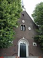
| Location | Oud-Zuilen, Stichtse Vecht, Utrecht, Netherlands | ||||
| Street address |
| ||||
| Heritage designation |
| ||||
| Religion or worldview | |||||
 | |||||
Nederlands: Ned. Hervormde Kerk - anno 1848 - in gebruik als cultureel centrum
|
This is a category about rijksmonument number 26473
|
| Address |
|
Media in category "Hervormde kerk (Oud-Zuilen)"
The following 10 files are in this category, out of 10 total.
-
 Beschoeiing in sloot naast de kerk - Oud-Zuilen - 20180925 - RCE.jpg 1,195 × 1,200; 487 KB
-
 Beschoeiing naast de kerk - Oud-Zuilen - 20180924 - RCE.jpg 1,190 × 1,200; 418 KB
-
 Cartouches - Oud-Zuilen - 20180922 - RCE.jpg 1,200 × 809; 301 KB
-
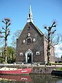 Hervormde kerk te Oud-Zuilen.JPG 2,448 × 3,264; 3.91 MB
-
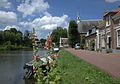 In Oud-Zuilen aangekomen in de Dorpsstaat.jpg 4,525 × 3,173; 4.25 MB
-
 Interieur, aanzicht orgel, orgelnummer 1213 - Oud-Zuilen - 20417821 - RCE.jpg 954 × 1,200; 203 KB
-
 Met Nederlands Hervormde Kerk - Zuilen - 20226042 - RCE.jpg 1,200 × 804; 213 KB
-
 Ornamenten aan de gevel van de Hervormde kerk in Oud-Zuilen.jpg 5,170 × 3,250; 3.23 MB
-
 Rijksmonument26473.JPG 1,920 × 2,560; 946 KB
-
 Rijksmonument26475.JPG 1,920 × 2,560; 980 KB


