Category:Hervormde Kerk ('s-Gravendeel)
Jump to navigation
Jump to search
| Object location | | View all coordinates using: OpenStreetMap |
|---|
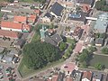
Nederlands: 's-Gravendeel, Hendrik Hamerstraat 1 - Hervormde Kerk - anno 1905 - ook wel Kerk op de Heul - Pauluskerk
Media in category "Hervormde Kerk ('s-Gravendeel)"
The following 6 files are in this category, out of 6 total.
-
 's Gravendeel, kerk foto4 2010-09-11 18.07.JPG 2,592 × 3,456; 5.92 MB
-
 's-Gravendeel, de Kerk op de Heul GM1963-WN13 IMG 0979 2021-09-06 17.30.jpg 4,408 × 3,408; 7.99 MB
-
 Hervormde kerk in 's-Gravendeel.JPG 925 × 694; 285 KB
-
 Hervormde kerk te s-Gravendeel.JPG 1,024 × 768; 436 KB
-
 Overzicht koor - 's-Gravendeel - 20377445 - RCE.jpg 1,200 × 930; 323 KB
-
 S Gravendeel Nederlands Hervormde kerk.jpg 1,500 × 1,500; 1.33 MB


