Category:Hernando de Soto Bridge
Steel-arch bridge in the United States   | |||||
| Upload media | |||||
| Instance of | |||||
|---|---|---|---|---|---|
| Location |
| ||||
| Maintained by | |||||
| Crosses | |||||
| Carries | |||||
| Inception |
| ||||
| Date of official opening |
| ||||
| Date of official closure |
| ||||
| Width |
| ||||
| Length |
| ||||
 | |||||
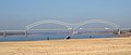
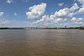
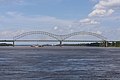
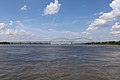
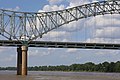
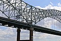
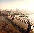
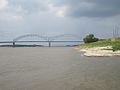
The Hernando de Soto Bridge is a through arch bridge carrying Interstate 40 across the Mississippi River between West Memphis, Arkansas and Memphis, Tennessee. It is often called the "M Bridge" as the arches resemble the letter M. Memphians also call the bridge the "New Bridge" as it is newer than the Memphis & Arkansas Bridge (carrying Interstate 55) downstream.
The bridge is named for 16th century Spanish explorer Hernando de Soto who explored this stretch of the Mississippi River, and died south of Memphis, Tennessee. His body was believed to have been buried in the Mississippi River after his death (although, according to legend, his body lay at the bottom of Lake Chicot in Arkansas, an oxbow lake of the Mississippi River about 130 miles south of Memphis.)
Media in category "Hernando de Soto Bridge"
The following 81 files are in this category, out of 81 total.
-
 040i desoto2.jpg 1,656 × 1,242; 588 KB
-
 040i tn exit 001 apch 2.jpg 1,656 × 1,242; 597 KB
-
 ArkansasMissRiver.JPG 3,264 × 2,448; 762 KB
-
 Crittenden County Museum Earle AR 2012-06-16 003.jpg 1,024 × 768; 595 KB
-
 Day 4 - 3166756437.jpg 1,600 × 1,200; 395 KB
-
 Desoto bridge memphis.JPG 1,280 × 666; 471 KB
-
 Downtown cement silo Riverside Dr Memphis TN 03.jpg 1,920 × 1,440; 1.94 MB
-
 Downtown cement silo Riverside Dr Memphis TN 04.jpg 1,920 × 1,440; 1.85 MB
-
 Downtown concrete silo near Pyramid Arena Memphis TN 004.jpg 1,024 × 769; 623 KB
-
 Downtown concrete silo near Pyramid Arena Memphis TN 005.jpg 1,024 × 768; 673 KB
-
 Downtown concrete silo near Pyramid Arena Memphis TN 009.jpg 1,024 × 767; 637 KB
-
 HdeSBMemphis (cropped).JPG 1,604 × 676; 764 KB
-
 HdeSBMemphis.JPG 1,728 × 1,152; 695 KB
-
 Hernando de Soto Bridge 2022a.jpg 6,240 × 4,160; 7.69 MB
-
 Hernando de Soto Bridge 2022b.jpg 6,240 × 4,160; 7.96 MB
-
 Hernando de Soto Bridge 2022c.jpg 6,240 × 4,160; 8.11 MB
-
 Hernando de Soto Bridge 2022d.jpg 6,240 × 4,160; 8.36 MB
-
 Hernando de Soto Bridge 2022e.jpg 6,240 × 4,160; 8.25 MB
-
 Hernando de Soto Bridge 2022f.jpg 6,240 × 4,160; 7.77 MB
-
 Hernando de Soto Bridge 2022g.jpg 6,240 × 4,160; 7.88 MB
-
 Hernando de Soto Bridge 2022h.jpg 6,240 × 4,160; 5.04 MB
-
 Hernando de Soto Bridge 2022i.jpg 6,240 × 4,160; 8.81 MB
-
 Hernando de Soto Bridge 2022j.jpg 6,240 × 4,160; 8.05 MB
-
 Hernando de Soto Bridge 2022k.jpg 6,240 × 4,160; 7.35 MB
-
 Hernando De Soto Bridge aerial view.jpg 2,181 × 1,278; 3.7 MB
-
 Hernando De Soto Bridge Memphis TN 018.jpg 768 × 1,024; 615 KB
-
 Hernando de Soto Bridge Memphis.jpg 1,500 × 1,438; 391 KB
-
 Hernando DeSoto Bridge (I-40) P9120095.jpg 2,048 × 1,536; 627 KB
-
 Hernando DeSoto Bridge (I-40) P9140278.jpg 3,072 × 2,304; 1.15 MB
-
 Hernando DeSoto Bridge (I-40) P9140286.jpg 3,072 × 2,304; 1.1 MB
-
 Hernando DeSoto Bridge (I-40) P9140370.jpg 3,072 × 2,304; 1.18 MB
-
 Hernando DeSoto Bridge (looking downriver).jpg 1,024 × 559; 473 KB
-
 Hernando DeSoto Bridge - panoramio.jpg 3,264 × 2,448; 3.75 MB
-
 Hernando DeSoto Bridge at night.jpg 700 × 464; 186 KB
-
 Hernando DeSoto Bridge from Mud Island Memphis TN 01.jpg 1,024 × 768; 451 KB
-
 Hernando DeSoto Bridge from Mud Island Memphis TN 02.jpg 1,024 × 768; 446 KB
-
 Hernando DeSoto Bridge from Mud Island Memphis TN.jpg 1,920 × 1,440; 1.72 MB
-
 Hernando DeSoto Bridge Memphis TN 01 from Downtown ramp.jpg 1,920 × 1,440; 1.64 MB
-
 Hernando DeSoto Bridge Memphis TN 02 from Downtown ramp.jpg 1,920 × 1,440; 1.68 MB
-
 Hernando DeSoto Bridge Memphis TN 2012-07-22 006.jpg 1,024 × 768; 505 KB
-
 Hernando DeSoto Bridge Memphis TN 2012-07-22 010.jpg 1,024 × 768; 485 KB
-
 Hernando deSoto Bridge.JPG 1,600 × 1,200; 336 KB
-
 Hernando-Desoto Bridge - panoramio.jpg 4,272 × 2,848; 4.82 MB
-
 HernandoDeSoto Bridge from Martyr's Park.JPG 6,000 × 4,000; 8.41 MB
-
 HernandoDeSoto Bridge Pyramid.jpg 6,000 × 4,000; 9.45 MB
-
 HernandoDeSotoBridge at Night.jpg 4,951 × 3,301; 7.71 MB
-
 I-40 deadend ramp 2010-10-02 Downtown Memphis TN 01.jpg 1,920 × 1,440; 1.38 MB
-
 I-40 deadend ramp 2010-10-02 Downtown Memphis TN 02.jpg 1,920 × 1,440; 1.47 MB
-
 I-40 East Exit 1 - Riverside Drive - Memphis (30578450652).jpg 2,400 × 1,600; 1.7 MB
-
 I-40 Hernando de Soto Bridge from Tom Lee Park - panoramio.jpg 1,600 × 1,200; 520 KB
-
 Island Queen from Tom Lee Park Memphis TN 00.jpg 1,024 × 768; 570 KB
-
 Island Queen from Tom Lee Park Memphis TN 01.jpg 1,024 × 768; 564 KB
-
 Island Queen from Tom Lee Park Memphis TN 02.jpg 1,024 × 768; 560 KB
-
 Memphis Bridge (Memphis, TN, USA).jpg 2,396 × 1,440; 592 KB
-
 Memphis Bridge (TN, USA).jpg 3,066 × 1,838; 847 KB
-
 Memphis Bridge from Main Street - panoramio.jpg 2,048 × 1,536; 1.01 MB
-
 Memphis Bridge.jpg 3,456 × 2,592; 5.37 MB
-
 Memphis highway plan 1955.png 713 × 616; 368 KB
-
 Memphis IMG 2830 Confederate Park - Hernando de Soto Bridge.jpg 4,032 × 3,024; 4.62 MB
-
 Memphis in Front of Me, Arkansas in Back of Me.jpg 1,345 × 1,026; 405 KB
-
 Memphis Mississippi River Bridge I-40 - panoramio.jpg 3,264 × 1,952; 1.35 MB
-
 Memphis, TN, USA - panoramio.jpg 3,264 × 1,952; 897 KB
-
 Mississippi River flooding at Memphis, 2011.jpg 3,938 × 1,045; 715 KB
-
 Mississippi River seen from I-40.jpg 3,648 × 2,736; 955 KB
-
 MS River Greenbelt Park Memphis TN 12.jpg 1,920 × 1,440; 1.93 MB
-
 MS River Greenbelt Park Memphis TN 21.jpg 1,024 × 768; 736 KB
-
 Mud Island Monorail P9140418.jpg 640 × 480; 75 KB
-
 Mud Island Monorail P9170792.jpg 3,072 × 2,304; 1.62 MB
-
 Record Lows of the Mississippi River by Memphis.jpg 6,000 × 4,000; 16.31 MB
-
 River Walk P9140424.JPG 640 × 480; 59 KB
-
 South Main Street Historic District Memphis TN 2012-04-15 016.jpg 1,024 × 768; 776 KB
-
 Tank transported on I-40 Memphis TN 2013-03-09 001.jpg 1,024 × 769; 518 KB
-
 Tennessee.JPG 437 × 295; 293 KB
-
 Tn welcome.jpg 1,656 × 1,242; 588 KB
-
 USACE provides update on floodfighting efforts.jpg 2,048 × 1,356; 515 KB
-
Video DeSoto Bridge part 1.theora.ogv 24 s, 640 × 480; 6.96 MB
-
Video DeSoto Bridge part 2.theora.ogv 24 s, 640 × 480; 13.59 MB
-
Video DeSoto Bridge part 3.theora.ogv 22 s, 640 × 480; 8.53 MB
-
Video Downtown Memphis TN 1.theora.ogv 44 s, 640 × 480; 15.09 MB
-
 West Memphis I-40 Bridge.jpg 2,500 × 1,667; 827 KB
-
 Westbound ramps of the Hernando DeSoto Bridge from Mud Island Memphis TN.jpg 1,920 × 1,440; 1.38 MB


.JPG)


_P9120095.jpg)
_P9140278.jpg)
_P9140286.jpg)
_P9140370.jpg)
.jpg)


.jpg)


.jpg)
.jpg)


- Bridges in Crittenden County, Arkansas
- Downtown Memphis, Tennessee
- Mississippi River at Memphis, Tennessee
- Road bridges in Memphis, Tennessee
- Visitor attractions in Memphis, Tennessee
- Interstate 40 in Arkansas
- Interstate 40 in Tennessee
- U.S. Route 64 in Arkansas
- U.S. Route 64 in Tennessee
- Bridges over the Mississippi River in Arkansas
- Bridges over the Mississippi River in Tennessee
- Tied arch bridges in Arkansas
- Tied arch bridges in Tennessee
- Road bridges in Arkansas
- 1970s bridges in Arkansas
- 1970s bridges in Tennessee
- Built in Arkansas in 1973
- Built in Tennessee in 1973
- Bridges in the United States completed in 1973
- Through arch bridges in the United States
- Bridges on Interstate 40
- Bridges on U.S. Route 64
- Longest arch bridges
- 6 kilometer bridges
- Hernando de Soto
- Arkansas-Tennessee border