Category:Herenstraat 60, Den Hoorn (Texel)
Jump to navigation
Jump to search
| Object location | | View all coordinates using: OpenStreetMap |
|---|
building in Texel, Netherlands  | |||||
| Upload media | |||||
| Instance of | |||||
|---|---|---|---|---|---|
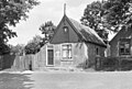
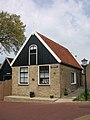
| Location | Den Hoorn, North Holland, Texel, North Holland, Netherlands | ||||
| Street address |
| ||||
| Located on street | |||||
| Heritage designation |
| ||||
 | |||||
Nederlands: Loodshuisje
|
This is a category about rijksmonument number 35240
|
| Address |
|
Media in category "Herenstraat 60, Den Hoorn (Texel)"
The following 3 files are in this category, out of 3 total.
-
 Aanzicht - Hoorn, Den (Texel) - 20116934 - RCE.jpg 1,200 × 808; 245 KB
-
 Den Hoorn - Herenstraat 60.jpg 1,944 × 2,592; 1.32 MB
-
 Met omgeving - Hoorn, Den (Texel) - 20116933 - RCE.jpg 1,200 × 808; 197 KB
_-_20116934_-_RCE.jpg)
_-_20116933_-_RCE.jpg)