Category:Heldsberg
Jump to navigation
Jump to search
| Object location | | View all coordinates using: OpenStreetMap |
|---|
historical museum in St. Margrethen (Switzerland)  | |||||
| Upload media | |||||
| Instance of |
| ||||
|---|---|---|---|---|---|
| Location | St. Margrethen, Rheintal Constituency, canton St. Gallen, Switzerland | ||||
| Street address |
| ||||
| Inception |
| ||||
| official website | |||||
 | |||||
Subcategories
This category has the following 3 subcategories, out of 3 total.
S
- Sperrstelle Steinig Tisch (7 F)
Media in category "Heldsberg"
The following 13 files are in this category, out of 13 total.
-
 150 Jahre Rheintallinie - E 33 Heerbrugg - Rorschach.jpg 2,881 × 1,915; 1.64 MB
-
 Fort Heldsberg - Switzerland.jpg 3,441 × 2,294; 5.41 MB
-
 Geschütz Heldsberg.JPG 3,000 × 2,250; 2.17 MB
-
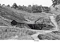
 Heldsberg Aussenbereich.jpg 637 × 396; 107 KB
-
 Heldsberg Bunker.jpg 640 × 480; 105 KB
-
 Heldsberg Eingangsgebäude.jpg 6,016 × 4,016; 24.2 MB
-
 Heldsberg Schlafsaal.jpg 1,001 × 667; 63 KB
-
 Maschienengewehr(Mg) 4, Bunkerkanone(BK) 3 und Bunkerkanone(BK) 4.jpg 1,120 × 752; 268 KB
-
 Rheineck Castle - Infantry LMG Position (49705091736).jpg 5,200 × 3,466; 14.25 MB
-
 Rheineck Castle - Infantry LMG Position (49705092361).jpg 5,200 × 3,466; 12.57 MB
-
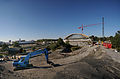 SBB A13 Brücke St Margrethen 09.jpg 5,048 × 3,333; 12.48 MB
-
 St. Margrethen - Bruggerhorn (18027185944).jpg 5,140 × 3,426; 12.88 MB
-
 Werk-Eingang der Festung Heldsberg.jpg 842 × 590; 286 KB


_4,_Bunkerkanone(BK)_3_und_Bunkerkanone(BK)_4.jpg)
.jpg)
.jpg)

.jpg)
