Category:Heizmann-Hof
Jump to navigation
Jump to search
| Object location | | View all coordinates using: OpenStreetMap |
|---|
human settlement in Austria  | |||||
| Upload media | |||||
| Instance of | |||||
|---|---|---|---|---|---|
| Location |
| ||||
| Street address |
| ||||
| Heritage designation | |||||
 | |||||
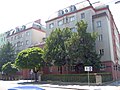
Deutsch: das Haus Vorgartenstraße 142 in der Leopoldstadt, in Wien

| Address |
|
Subcategories
This category has only the following subcategory.
L
- Haus Lassallestraße 19, Wien (3 F)
Media in category "Heizmann-Hof"
The following 8 files are in this category, out of 8 total.
-
 Haus-Vorgartenstraße 142-01.jpg 2,000 × 1,500; 1.9 MB
-
 Heizmann-Hof.jpg 5,014 × 3,666; 3.46 MB
-
 Wien 02 Heizmann-Hof a.jpg 3,000 × 2,162; 2.86 MB
-
 Wien 02 Heizmann-Hof b.jpg 3,000 × 2,151; 3.19 MB
-
 Wien 02 Heizmann-Hof c.jpg 3,000 × 1,687; 1.36 MB
-
 Wien 02 Heizmann-Hof d.jpg 3,000 × 5,055; 5.62 MB
-
 Wien 02 Heizmann-Hof e.jpg 3,000 × 1,688; 2.2 MB
-
 Wien 02 Heizmann-Hof f.jpg 2,000 × 2,000; 1.85 MB


