Category:Heilige Familiekerk ('t Kruis)
Jump to navigation
Jump to search
| Object location | | View all coordinates using: OpenStreetMap |
|---|
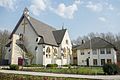
Nederlands: Heilige Familiekerk in Heerhugowaard (t Kruis) - anno 1923 - Rooms-Katholieke Kerk
| Address |
|
Media in category "Heilige Familiekerk ('t Kruis)"
The following 3 files are in this category, out of 3 total.
-
 Heilige Familiekerk en pastorie in 't Kruis.jpg 5,472 × 3,648; 12.34 MB
-
 Heilige Familiekerk en pastorie, t Kruis.jpg 5,472 × 3,648; 11.71 MB
-
 Overzicht westgevel, met ingangspartij, en noordgevel - 't Kruis - 20405312 - RCE.jpg 3,460 × 2,760; 2.51 MB


