Category:Heerenstraat 22, Doesburg
Jump to navigation
Jump to search
| Object location | | View all coordinates using: OpenStreetMap |
|---|
building in Doesburg, Netherlands  | |||||
| Upload media | |||||
| Instance of | |||||
|---|---|---|---|---|---|
| Location | Doesburg, Gelderland, Netherlands | ||||
| Street address |
| ||||
| Located on street | |||||
| Heritage designation |
| ||||
 | |||||
|
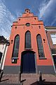
This is a category about rijksmonument number 12970
|
| Address |
|
Media in category "Heerenstraat 22, Doesburg"
The following 5 files are in this category, out of 5 total.
-
 Doesburg, Netherlands - panoramio (212).jpg 4,896 × 3,264; 4.36 MB
-
 Doesburg, Netherlands - panoramio (98).jpg 2,176 × 3,264; 1.15 MB
-
 Overzicht straatwand - Doesburg - 20058146 - RCE.jpg 807 × 1,200; 156 KB
-
 RM12970 Doesburg - Herenstraat 22.jpg 1,944 × 2,592; 976 KB
-
 Vanuit de Boekholtstr. - Doesburg - 20058137 - RCE.jpg 800 × 1,200; 170 KB
.jpg)
.jpg)

