Category:Haus des Handwerks (Leer)
Jump to navigation
Jump to search
| Object location | | View all coordinates using: OpenStreetMap |
|---|
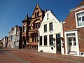
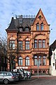
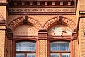
Deutsch: Haus des Handwerks, Neue Straße 8 in Leer (Ostfriesland)
| Upload media | |||||
| Instance of | |||||
|---|---|---|---|---|---|
| Location | Leer, Lower Saxony, Germany | ||||
 | |||||
Media in category "Haus des Handwerks (Leer)"
The following 22 files are in this category, out of 22 total.
-
 Gasthof zur Leda 2019-04-21 - 1.jpg 4,896 × 3,672; 6.23 MB
-
 Gasthof zur Leda 2019-04-21 - 2.jpg 4,896 × 3,672; 6.08 MB
-
 Hafenmusik and der Waage in Leer - Ostfriesland - panoramio.jpg 923 × 588; 267 KB
-
 Leer - Dr.-vom-Bruch-Brücke + Rathausstraße + Rathaus 03 ies.jpg 5,616 × 3,744; 17.1 MB
-
 Leer - Neue Straße + 6 + 8 + 10 + 12 01 ies.jpg 5,616 × 3,744; 18.35 MB
-
 Leer - Neue Straße - 8Haus des Handwerks 01 ies.jpg 3,695 × 5,616; 17.92 MB
-
 Leer - Neue Straße - 8Haus des Handwerks 02 ies.jpg 5,616 × 3,744; 16.82 MB
-
 Leer - Neue Straße - 8Haus des Handwerks 03 ies.jpg 3,744 × 5,616; 18.4 MB
-
 Leer - Neue Straße - 8Haus des Handwerks 04 ies.jpg 3,744 × 5,616; 17.45 MB
-
 Leer - Neue Straße - 8Haus des Handwerks 05 ies.jpg 3,744 × 5,616; 16.26 MB
-
 Leer - Neue Straße - 8Haus des Handwerks 06 ies.jpg 3,744 × 5,616; 15.93 MB
-
 Leer - Neue Straße - 8Haus des Handwerks 07 ies.jpg 3,744 × 5,616; 19.97 MB
-
 Leer - Neue Straße - 8Haus des Handwerks 08 ies.jpg 5,616 × 3,744; 20.7 MB
-
 Leer - Neue Straße - 8Haus des Handwerks 09 ies.jpg 5,616 × 3,744; 17.11 MB
-
 Leer - Neue Straße - 8Haus des Handwerks 10 ies.jpg 5,616 × 3,744; 17.93 MB
-
 Leer - Neue Straße - 8Haus des Handwerks 11 ies.jpg 5,616 × 3,745; 16.6 MB
-
 Leer - Neue Straße - 8Haus des Handwerks 12 ies.jpg 5,616 × 3,744; 17.18 MB
-
 Leer - Neue Straße - 8Haus des Handwerks 13 ies.jpg 5,616 × 3,744; 21.4 MB
-
 Leer - Neue Straße - Alte Waage + 8Haus des Handwerks + Rathaus 01 ies.jpg 5,616 × 3,744; 19.12 MB
-
 Leer - Neue Straße - Alte Waage + 8Haus des Handwerks + Rathaus 02 ies.jpg 5,616 × 3,745; 18.27 MB
-
 Leer - Neue Straße - Museumshafen + Hafenmusik (Dr.-vom-Bruch-Brücke) 01 ies.jpg 5,616 × 3,744; 18.59 MB
-
 Leer - Neue Straße - Museumshafen + Hafenmusik (Dr.-vom-Bruch-Brücke) 02 ies.jpg 5,616 × 3,744; 18.79 MB


_01_ies.jpg)
_02_ies.jpg)