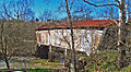
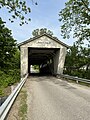
Category:Harshaville Covered Bridge
Jump to navigation
Jump to search
|
This is a category about a place or building that is listed on the National Register of Historic Places in the United States of America. Its reference number is 76001357. |
| Object location | | View all coordinates using: OpenStreetMap |
|---|
bridge in Adams County, Ohio, United States  | |||||
| Upload media | |||||
| Instance of | |||||
|---|---|---|---|---|---|
| Location | Adams County, Ohio | ||||
| Heritage designation |
| ||||
 | |||||
Media in category "Harshaville Covered Bridge"
The following 8 files are in this category, out of 8 total.
-
 Harshaville Covered Bridge (123449629).jpg 1,805 × 1,219; 655 KB
-
 HARSHAVILLE COVERED BRIDGE, ADAMS COUNTY, OHIO.jpg 653 × 430; 98 KB
-
 Harshaville Covered Bridge-2 (123711934).jpg 900 × 618; 326 KB
-
 Harshaville Covered Bridge-3 (123723186).jpg 1,878 × 1,320; 703 KB
-
 Harshaville Covered Bridge-4.jpg 1,024 × 561; 401 KB
-
 Harshaville Covered Bridge.jpg 5,868 × 7,822; 11.75 MB
-
 HarshavilleOH3.JPG 4,608 × 2,592; 4.08 MB
-
 Inside of Harshaville Covered Bridge.jpg 6,048 × 8,064; 9.23 MB
.jpg)

.jpg)
.jpg)


