Category:Harleston, Norfolk
Jump to navigation
Jump to search
English: Harleston is a town located in the southern limits of the county of Norfolk. It shares a parish with the village of Redenhall; the parish has a total area of and the population of the parish is 4058 Many Georgian residences line the streets and a bustling market takes place every Wednesday. Harleston is situated in the South Norfolk District Council area. It was once home to Harleston railway station on the Waveney Valley Line.
town in Norfolk, England, UK  | |||||
| Upload media | |||||
| Instance of | |||||
|---|---|---|---|---|---|
| Location | Redenhall with Harleston, South Norfolk, Norfolk, East of England, England | ||||
| official website | |||||
 | |||||
Subcategories
This category has the following 4 subcategories, out of 4 total.
Media in category "Harleston, Norfolk"
The following 22 files are in this category, out of 22 total.
-
 Burntoak Lane - geograph.org.uk - 1595603.jpg 480 × 640; 122 KB
-
 Closeup Of Clock Tower - geograph.org.uk - 534235.jpg 480 × 640; 73 KB
-
 Country Road - geograph.org.uk - 1595577.jpg 640 × 480; 102 KB
-
 End of the road - geograph.org.uk - 384328.jpg 640 × 480; 183 KB
-
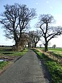
 Gatehouse - geograph.org.uk - 1595830.jpg 640 × 480; 104 KB
-
 Green Lane and Blake's Grove - geograph.org.uk - 369818.jpg 640 × 480; 109 KB
-
 Harleston Clock Tower - geograph.org.uk - 534211.jpg 640 × 480; 89 KB
-
 Harleston Town Sign - geograph.org.uk - 534205.jpg 480 × 640; 89 KB
-
 The A143 at Redenhall - geograph.org.uk - 40672.jpg 640 × 427; 97 KB
-
 The Thoroughfare, Harleston, Norfolk - geograph.org.uk - 1561492.jpg 640 × 371; 51 KB
-
 Town Centre, Harleston, Norfolk - geograph.org.uk - 1561488.jpg 640 × 450; 79 KB
-
 Two Red Boxes - geograph.org.uk - 534231.jpg 480 × 640; 94 KB
-

-
 Water Lane - geograph.org.uk - 3611171.jpg 1,024 × 768; 220 KB
-
 Watermill Cottage, Weybread Mill - geograph.org.uk - 772201.jpg 640 × 427; 87 KB
-
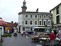 Wednesday Market - geograph.org.uk - 534217.jpg 640 × 480; 91 KB
-
 Which Way Now ^ - geograph.org.uk - 534241.jpg 480 × 640; 75 KB
-
 A view of Redenhall village - geograph.org.uk - 362081.jpg 640 × 455; 95 KB
-
 Footbridge over the Waveney - geograph.org.uk - 772203.jpg 427 × 640; 145 KB
-
 Green Lane, near Starston - geograph.org.uk - 362052.jpg 640 × 450; 68 KB
-
 Part of Shotford Hall Farm - geograph.org.uk - 362443.jpg 640 × 480; 65 KB
-


