Category:Harald Hårdrådes plass
Jump to navigation
Jump to search
| Object location | | View all coordinates using: OpenStreetMap |
|---|
.jpg) | |||||
| Upload media | |||||
| Instance of | |||||
|---|---|---|---|---|---|
| Named after | |||||
| Location | Oslo Municipality, Norway | ||||
| Heritage designation |
| ||||
 | |||||
Subcategories
This category has the following 3 subcategories, out of 3 total.
H
- Harald Hardrada monument, Oslo (13 F)
S
- Schweigaards gate 72, Oslo (4 F)
- Schweigaards gate 73, Oslo (4 F)
Media in category "Harald Hårdrådes plass"
The following 22 files are in this category, out of 22 total.
-

-
 1213 Oslo. Harald Haarraades plass - no-nb digifoto 20151106 00118 bldsa PK07983.jpg 7,062 × 4,809; 2.17 MB
-
 1251 Kristiania. Harald Haarraades Plass - no-nb digifoto 20151106 00117 bldsa PK07982.jpg 7,171 × 4,730; 1.86 MB
-
 1252 Kristiania. Harald Haarraades Plass - no-nb digifoto 20151106 00116 bldsa PK07981.jpg 7,238 × 4,808; 2.22 MB
-
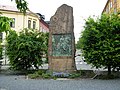 Bauta Harald Hardrades plass.JPG 3,072 × 2,304; 1.31 MB
-
 Gamlebyen klostergt 3 rk 164883 IMG 8532.JPG 1,728 × 2,182; 610 KB
-
 Gamlebyen klostergt 3 rk 164883 IMG 8533.JPG 1,728 × 2,592; 687 KB
-
 Gamlebyen schweigaardsgt 68 rk 164716 IMG 8523.JPG 2,325 × 1,302; 724 KB
-
 Gamlebyen schweigaardsgt 71 rk 164924 IMG 8524.JPG 1,728 × 2,592; 840 KB
-
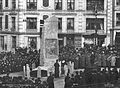 Harald Haardraades Bautas Afsløring Oslo 26 Oktober 1905 OB.Y1548.jpg 800 × 588; 233 KB
-
 Harald Hardrades plass.jpg 3,072 × 2,304; 1.43 MB
-
 Harald Hårdrådes plass (2016).jpg 3,160 × 2,014; 1.13 MB
-
 Harald Hårdrådes plass - skilt.jpg 2,491 × 1,854; 670 KB
-
 Harald Hårdrådes plass sett mot sentrum med nr 70 til høyre.jpg 5,437 × 3,257; 1.35 MB
-
 Harald Hårdrådes plass sett oppover Schweigaards gate.jpg 5,568 × 3,712; 1.67 MB
-
 Harald Hårdrådes plass, 2023.jpg 4,032 × 3,024; 6.87 MB
-
 Harald Hårdrådes plass, Oslo 2023.jpg 3,992 × 2,994; 4.48 MB
-
 Harald Sigurssons statu - no-nb digifoto 20130115 00097 NB MS G3 0097.jpg 7,210 × 5,410; 3.37 MB
-
 Schweigaards gate 68-70.jpg 1,600 × 816; 1.08 MB
-
 Schweigaards gate 69-71 Oslo.jpg 945 × 532; 422 KB
-
 Schweigaards gate 70 på Harald Hårdrådes plass.jpg 5,568 × 3,712; 1.55 MB
-
 Schweigaards gate 74.jpg 1,600 × 1,050; 1.43 MB


