Category:Gwersyllt
Jump to navigation
Jump to search
village and community in Wrexham County Borough, Wales   | |||||
| Upload media | |||||
| Pronunciation audio | |||||
|---|---|---|---|---|---|
| Instance of | |||||
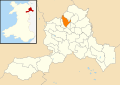
| Location | Wrexham County Borough, Wales | ||||
| Population |
| ||||
| Area |
| ||||
 | |||||
Cymraeg: Pentref o faint sylweddol yn mwrdeisdref sirol Wrecsam yw Gwersyllt. Saif ychydig i'r gogledd o dref Wrecsam, ger y briffordd A541.
English: Gwersyllt is a densely populated urban village in the suburbs of Wrexham in Wales. It forms part of the Wrexham Urban Area (pop 63,000) and is one of Wrexham's largest villages. It is situated in the north western suburbs of Wrexham County Borough, bordering the nearby villages of Bradley, Llay, Cefn-y-Bedd, Summerhill and Sydallt. The name is derived from the Welsh word, "Gwersyll" meaning "campsite".
Subcategories
This category has the following 8 subcategories, out of 8 total.
D
G
- Gwersyllt Fish Bar (3 F)
- Gwersyllt railway station (50 F)
- Gwersyllt War Memorial (7 F)
H
- Holy Trinity Church, Gwersyllt (30 F)
W
- The Wheatsheaf, Gwersyllt (6 F)
Y
- Ysgol Bro Alun, Gwersyllt (5 F)
Media in category "Gwersyllt"
The following 119 files are in this category, out of 119 total.
-
 A leafy walk in Alyn Waters Country Park - geograph.org.uk - 3723185.jpg 480 × 640; 115 KB
-
-
 A483 - geograph.org.uk - 4476589.jpg 640 × 368; 53 KB
-
 A483 - New Road overbridge (B5425) - geograph.org.uk - 2250331.jpg 640 × 480; 59 KB
-
 A483 at Bryn Alyn railway bridge - geograph.org.uk - 2250353.jpg 640 × 480; 50 KB
-
 A483 at junction 6 (A5156) - geograph.org.uk - 2250339.jpg 640 × 480; 54 KB
-
 A483 at Junction 6 (for Gresford) - geograph.org.uk - 5503671.jpg 640 × 480; 408 KB
-
 A483 at junction 6 bridges - geograph.org.uk - 2250343.jpg 640 × 480; 57 KB
-
 A483 at Mold Road Interchange - geograph.org.uk - 5503540.jpg 640 × 480; 380 KB
-
 A483 at the railway bridges - geograph.org.uk - 2250327.jpg 640 × 480; 55 KB
-
 A483 heading north - geograph.org.uk - 3861582.jpg 640 × 480; 42 KB
-
 A483 layby near Wrexham - geograph.org.uk - 4605834.jpg 1,024 × 633; 132 KB
-
 A483 near Garden Suburb - geograph.org.uk - 3291409.jpg 640 × 481; 39 KB
-
 A483 near Wrexham - geograph.org.uk - 5503665.jpg 640 × 427; 347 KB
-
 A483 northbound at Junction 6 - geograph.org.uk - 3861584.jpg 640 × 481; 47 KB
-
 A483 towards Chester - geograph.org.uk - 6164011.jpg 800 × 600; 90 KB
-
 A483 west of Plas Coch - geograph.org.uk - 3861580.jpg 640 × 481; 44 KB
-

-
 Alyn Waters Country Park entrance - geograph.org.uk - 4455113.jpg 640 × 338; 129 KB
-
 Aurelius House, Gwersyllt.JPG 4,608 × 3,456; 3.51 MB
-
 B5425 towards Llay - geograph.org.uk - 6164034.jpg 800 × 600; 125 KB
-
 Bench mark on Bethel Lane railway bridge - geograph.org.uk - 5646117.jpg 1,024 × 768; 248 KB
-
 Bethel Lane railway bridge, near Gwersyllt - geograph.org.uk - 5646127.jpg 1,024 × 769; 279 KB
-
 Betting shop, Gwersyllt.JPG 4,608 × 3,456; 3.55 MB
-
 Borderlands Line passes High Street, Gwersyllt.JPG 4,608 × 3,456; 3.7 MB
-

-
 Bradley Mill Bridge and a bench mark - geograph.org.uk - 4306409.jpg 640 × 480; 120 KB
-
 Bradley village on a summer's evening - geograph.org.uk - 2474627.jpg 1,024 × 247; 49 KB
-
 Bryn Alyn School, Gwersyllt - geograph.org.uk - 623426.jpg 640 × 480; 90 KB
-

-
 Car wash and Conservatory show area - geograph.org.uk - 2483776.jpg 640 × 396; 49 KB
-
 Cattle grazing near pond, Gwersyllt - geograph.org.uk - 6164032.jpg 800 × 600; 121 KB
-
 Commemorative bench - geograph.org.uk - 5802151.jpg 640 × 427; 110 KB
-
 Countryside View From A483 - geograph.org.uk - 5230864.jpg 4,608 × 3,456; 5.9 MB
-
 Crossing the Mold Road, Gwersyllt - geograph.org.uk - 623424.jpg 640 × 480; 105 KB
-

-
 Dodds Lane substation, Gwersyllt.JPG 4,608 × 3,456; 3.41 MB
-
 Elizabeth II postbox on Main Road, Gwersyllt - geograph.org.uk - 6164642.jpg 2,304 × 4,260; 1.83 MB
-
 End of Wilderness Road - geograph.org.uk - 5960181.jpg 1,024 × 683; 392 KB
-
 Fairwood Drive junction from A541 - geograph.org.uk - 4455136.jpg 640 × 382; 174 KB
-
 Ffordd Fferm Uchaf - geograph.org.uk - 4995942.jpg 3,264 × 2,448; 3.5 MB
-
 Ffrwd Methodist Church - geograph.org.uk - 623430.jpg 640 × 480; 75 KB
-
 Ffrwd Primitive Methodist Chapel - geograph.org.uk - 5700838.jpg 640 × 480; 82 KB
-
 Footbridge over A483 close to A5156 junction - geograph.org.uk - 4488483.jpg 1,600 × 1,067; 1.26 MB
-
 Footbridge over the A483 at Junction 6 - geograph.org.uk - 5503681.jpg 640 × 480; 374 KB
-
 Footbridge over the railway at Gwersyllt.JPG 4,608 × 3,456; 3.42 MB
-

-
 FourWrexhamBlueBirds.jpg 1,532 × 846; 299 KB
-

-
 Grazing off Main Road, Gwersyllt - geograph.org.uk - 6164019.jpg 800 × 600; 88 KB
-

-
 Gresford Mining disaster memorial - geograph.org.uk - 5801642.jpg 640 × 427; 84 KB
-
 Gresford stone carving - geograph.org.uk - 5802193.jpg 640 × 427; 87 KB
-
 Gwersyllt Community Primary School - geograph.org.uk - 2809679.jpg 640 × 454; 43 KB
-
 Gwersyllt Congregational Church - geograph.org.uk - 6164022.jpg 800 × 542; 79 KB
-
 Gwersyllt CP School, Wrexham (1).JPG 4,608 × 3,456; 3.26 MB
-
 Gwersyllt CP School, Wrexham (2).JPG 4,608 × 3,456; 3.23 MB
-
 Gwersyllt railway station - geograph.org.uk - 3440552.jpg 1,024 × 768; 211 KB
-
 Hair salon, Gwersyllt.JPG 4,608 × 3,456; 3.5 MB
-
 High Street Dental Surgery, Gwersyllt (1).JPG 4,608 × 3,456; 3.56 MB
-
 High Street Dental Surgery, Gwersyllt (2).JPG 4,608 × 3,456; 3.53 MB
-
 Hillside grazing off the B5425 - geograph.org.uk - 6164033.jpg 800 × 600; 105 KB
-
 Holy Trinity Church, Gwersyllt (1) - geograph.org.uk - 3723175.jpg 480 × 640; 73 KB
-
 Holy Trinity Church, Gwersyllt (2) - geograph.org.uk - 3723178.jpg 480 × 640; 66 KB
-
 Houses in Pandy, Merionethshire - geograph-4476569.jpg 640 × 426; 78 KB
-
 Houses on Main Road, Gwersyllt - geograph.org.uk - 6164018.jpg 800 × 517; 65 KB
-

-
 Junction 4 bridges, A483 - geograph.org.uk - 2250310.jpg 640 × 480; 60 KB
-
 Junction 4, A483 - geograph.org.uk - 2250308.jpg 640 × 480; 53 KB
-
 Lay-by on A483 north of Wrexham - geograph.org.uk - 4486185.jpg 1,600 × 1,200; 1.37 MB
-
 Lidl supermarket, Gwersyllt.JPG 4,608 × 3,456; 3.45 MB
-
 Looking towards Gwersyllt from Main Road, Rhosrobin.JPG 4,608 × 3,456; 3.95 MB
-
 Low bridge ahead - geograph.org.uk - 2808823.jpg 640 × 480; 131 KB
-
 Main Road, Gwersyllt - geograph.org.uk - 6164023.jpg 800 × 600; 112 KB
-
 Marshland near Bradley - geograph.org.uk - 2840982.jpg 640 × 480; 90 KB
-
 Mason's mark on Bradley Mill Bridge ^2 - geograph.org.uk - 4307043.jpg 640 × 480; 199 KB
-
 Mathews Post Office, Gwersyllt (1).JPG 4,320 × 3,240; 2.85 MB
-
 Mathews Post Office, Gwersyllt (2).JPG 4,320 × 3,240; 2.95 MB
-
 Moss Valley Country Park, Wrexham - geograph.org.uk - 3747170.jpg 3,648 × 2,736; 4.76 MB
-
 New Llay Road, Bradley - geograph.org.uk - 6164037.jpg 800 × 600; 181 KB
-

-

-

-
 Open land at rear of Plas Acton Road - geograph.org.uk - 2408706.jpg 640 × 501; 64 KB
-
 Paper cup company near Wrexham - geograph.org.uk - 3525792.jpg 2,592 × 1,936; 1.72 MB
-

-
 Pendine Park Nursing Home - geograph.org.uk - 1585056.jpg 640 × 480; 81 KB
-
 Plas Acton Road, Gwersyllt - geograph.org.uk - 6164027.jpg 800 × 600; 99 KB
-

-
 Primitive Methodist Chapel, Ffrwd - geograph.org.uk - 5700843.jpg 640 × 480; 95 KB
-
 Rhosddu Industrial Estate - geograph.org.uk - 4967622.jpg 3,264 × 2,448; 3.55 MB
-
 Rhosrobin Road - geograph.org.uk - 2808837.jpg 640 × 480; 82 KB
-
 Road junction in Gwersyllt - geograph.org.uk - 4455127.jpg 640 × 355; 114 KB
-
 Road junction south of Country Park - geograph.org.uk - 4455122.jpg 640 × 383; 144 KB
-

-

-

-
 Shops on Dodds Lane, Gwersyllt (1).JPG 4,608 × 3,456; 3.41 MB
-
 Shops on Dodds Lane, Gwersyllt (2).JPG 4,608 × 3,456; 3.44 MB
-
 Shops on Dodds Lane, Gwersyllt (3).JPG 4,608 × 3,456; 3.26 MB
-
 Sliproad to Gresford Interchange - geograph.org.uk - 5503690.jpg 640 × 427; 386 KB
-

-
 Sydallt Lane - geograph.org.uk - 2808806.jpg 640 × 480; 92 KB
-
 Tesco off Dodds Lane - geograph.org.uk - 3949292.jpg 640 × 480; 60 KB
-
 Tesco supermarket, Gwersyllt.JPG 4,608 × 3,456; 3.35 MB
-
 Textiles manufacturer near Wrexham - geograph.org.uk - 3525799.jpg 2,592 × 1,936; 1.8 MB
-
-
 The Queens Head, Bradley - geograph.org.uk - 2808830.jpg 640 × 480; 57 KB
-
 The two bridges of the A541 crossing A483 - geograph.org.uk - 4486172.jpg 1,600 × 1,199; 1.3 MB
-
 Trees by the railway line - geograph.org.uk - 4476583.jpg 640 × 426; 100 KB
-
 Unpopular route^ - geograph.org.uk - 3703734.jpg 1,536 × 2,048; 892 KB
-
 View from Windy Hill northwards - geograph.org.uk - 2808810.jpg 640 × 480; 73 KB
-

-

-
 Wales Wrexham Community Gwersyllt map.svg 512 × 362; 495 KB
-
 Walk this way . . . - geograph.org.uk - 3703709.jpg 2,048 × 1,536; 703 KB
-
 Mountain View Industrial Estate - geograph.org.uk - 161033.jpg 640 × 480; 63 KB
-
 Small industrial estate at Pandy - geograph.org.uk - 161064.jpg 640 × 480; 78 KB
-
 Wrexham bypass - geograph.org.uk - 175242.jpg 640 × 477; 67 KB


_-_geograph.org.uk_-_2250331.jpg)

_-_geograph.org.uk_-_2250339.jpg)
_-_geograph.org.uk_-_5503671.jpg)


.JPG)
.JPG)


.JPG)
.JPG)

_-_geograph.org.uk_-_3723175.jpg)
_-_geograph.org.uk_-_3723178.jpg)


.JPG)
.JPG)


.JPG)
.JPG)
.JPG)


