Category:Gurk bridge Althofen - Mölbling
Jump to navigation
Jump to search
| Object location | | View all coordinates using: OpenStreetMap |
|---|
bridge in Austria  | |||||
| Upload media | |||||
| Instance of | |||||
|---|---|---|---|---|---|
| Location | Mölbling, Sankt Veit an der Glan District, Carinthia, Austria | ||||
| Street address |
| ||||
| Heritage designation | |||||
 | |||||
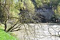
English: Baroque arched bridge across the Gurk river in Moelbling, municipality Mölbling, district St. Veit an der Glan, Carinthia / Austria / EU
Deutsch: Barocke Bogenbrücke über den Gurk-Fluss in Mölbling, Gemeinde Mölbling Bezirk St. Veit an der Glan, Kärnten / Österreich / EU
Media in category "Gurk bridge Althofen - Mölbling"
The following 3 files are in this category, out of 3 total.
-
 Moelbling Steingewoelbebruecke ueber die Gurk 18102012 551.jpg 4,288 × 2,848; 2.94 MB
-
 Moelbling Steingewoelbebruecke ueber die Gurk 18102012 555.jpg 4,288 × 2,848; 2.65 MB
-
 Moelbling Steingewoelbebruecke ueber die Gurk 18102012 556.jpg 4,288 × 2,848; 1.63 MB

