Category:Guinea Gap
Jump to navigation
Jump to search
| Object location | | View all coordinates using: OpenStreetMap |
|---|
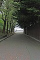
Guinea Gap is a pathway leading from Riverview Road, off Brighton Street, Seacombe, Wallasy, to Seacombe Promenade.
Media in category "Guinea Gap"
The following 4 files are in this category, out of 4 total.
-
 Guinea Gap 1.jpg 4,974 × 3,138; 8.16 MB
-
 Guinea Gap 2.jpg 3,456 × 5,184; 11.2 MB
-
 Guinea Gap 2017.jpg 5,020 × 3,096; 12.25 MB
-
 Guinea Gap 3.jpg 3,208 × 4,808; 9.14 MB


