Category:Grottenburg Hohfluh
Jump to navigation
Jump to search
| Object location | | View all coordinates using: OpenStreetMap |
|---|
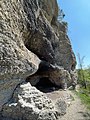
ruin of a cave castle in Bachs in the canton of Zürich, Switzerland  | |||||
| Upload media | |||||
| Instance of | |||||
|---|---|---|---|---|---|
| Part of | |||||
| Location |
| ||||
| Street address |
| ||||
| Heritage designation | |||||
 | |||||
Media in category "Grottenburg Hohfluh"
The following 12 files are in this category, out of 12 total.
-
 Grottenburg Hohfluh - 1 von 12.jpeg 4,032 × 3,024; 15.09 MB
-
 Grottenburg Hohfluh - 10 von 12.jpeg 3,024 × 4,032; 10.22 MB
-
 Grottenburg Hohfluh - 11 von 12.jpeg 3,912 × 2,908; 10.3 MB
-
 Grottenburg Hohfluh - 12 von 12.jpeg 3,024 × 4,032; 11.86 MB
-
 Grottenburg Hohfluh - 2 von 12.jpeg 3,024 × 4,032; 13.71 MB
-
 Grottenburg Hohfluh - 3 von 12.jpeg 4,032 × 3,024; 12.51 MB
-
 Grottenburg Hohfluh - 4 von 12.jpeg 3,024 × 4,032; 9.73 MB
-
 Grottenburg Hohfluh - 5 von 12.jpeg 4,032 × 3,024; 9.11 MB
-
 Grottenburg Hohfluh - 6 von 12.jpeg 3,024 × 4,032; 9.05 MB
-
 Grottenburg Hohfluh - 7 von 12.jpeg 3,963 × 2,803; 9.99 MB
-
 Grottenburg Hohfluh - 8 von 12.jpeg 4,032 × 3,024; 11.2 MB
-
 Grottenburg Hohfluh - 9 von 12.jpeg 3,024 × 4,032; 11.51 MB


