Category:Grime's Graves
Jump to navigation
Jump to search
flint mine in Norfolk, UK  | |||||
| Upload media | |||||
| Instance of |
| ||||
|---|---|---|---|---|---|
| Location |
| ||||
| Owned by | |||||
| Operator | |||||
| Heritage designation | |||||
| official website | |||||
 | |||||

Media in category "Grime's Graves"
The following 22 files are in this category, out of 22 total.
-
 Entrance to Grime's Graves - geograph.org.uk - 397322.jpg 640 × 480; 145 KB
-
 Entrance to Grimes Graves pit.jpg 2,592 × 1,552; 2.1 MB
-
 Grime's Graves Clarke 1963 Aerial View.tif 4,192 × 3,065; 40.66 MB
-
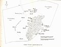 Grime's Graves Clarke 1963 General Plan.jpg 3,924 × 3,049; 1.52 MB
-
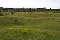
 Grime's Graves Flint Mine - geograph.org.uk - 1318810.jpg 640 × 480; 99 KB
-
 Grime's Graves, Thetford - geograph.org.uk - 1318785.jpg 640 × 480; 72 KB
-
 Grimes Grave Foxhole 2.jpg 1,552 × 2,592; 3.24 MB
-
 Grimes Grave foxhole.jpg 2,592 × 1,552; 2.86 MB
-
 Grimes Grave pits.jpg 2,592 × 1,552; 2.07 MB
-
 Grimes Graves (1).jpg 2,560 × 1,920; 1.39 MB
-
 Grimes Graves , neolithic flint mine - geograph.org.uk - 1007207.jpg 640 × 480; 101 KB
-
 Grimes Graves , Neolithic flint mine - geograph.org.uk - 1007212.jpg 640 × 480; 53 KB
-
 Grimes Graves Hut.jpg 2,592 × 1,552; 1.39 MB
-
 Grimes Graves, near Thetford, Norfolk - geograph.org.uk - 40466.jpg 640 × 427; 62 KB
-
 Grimes Graves, near Thetford, Norfolk - geograph.org.uk - 41510.jpg 640 × 427; 87 KB
-
 Grimes Graves.jpg 2,560 × 1,920; 924 KB
-
 Grimesgraves2.jpg 674 × 898; 46 KB
-
 Open Flint Mine. Grime's Graves - geograph.org.uk - 1318798.jpg 640 × 480; 80 KB
-
 Soil Zonation, Grime's Graves - geograph.org.uk - 1318825.jpg 640 × 480; 118 KB
-
 Track to Grime's Graves - geograph.org.uk - 1017452.jpg 640 × 427; 85 KB
-
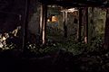
 Underground in Grimes Graves - Caught Knapping - panoramio.jpg 2,736 × 3,648; 3.77 MB
-
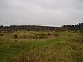
 Breckland Heath-Grassland Ecosystem - geograph.org.uk - 415793.jpg 640 × 480; 91 KB


.jpg)


