Category:Greystone Road railway bridge
Jump to navigation
Jump to search
| Object location | | View all coordinates using: OpenStreetMap |
|---|
Knowsley, Merseyside, L14.  | |||||
| Upload media | |||||
| Instance of | |||||
|---|---|---|---|---|---|
| Location | Knowsley, Merseyside, North West England, England | ||||
| Heritage designation |
| ||||
 | |||||
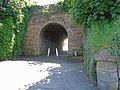
This is bridge DSE/46 on the Deal Street and Edge Hill Branch of the Merseyrail City Line; built 1828/30 by George Stephenson for the Liverpool and Manchester Railway, it is Grade II listed. It is 4.08 miles from Lime Street.
Media in category "Greystone Road railway bridge"
The following 3 files are in this category, out of 3 total.
-
 Greystone Road rail bridge 1.jpg 5,082 × 3,804; 8.73 MB
-
 Greystone Road rail bridge 2.jpg 4,524 × 3,510; 7.28 MB
-
 Greystone Road rail bridge 3.jpg 5,152 × 3,864; 10.66 MB

