Category:Great Howard Street bridge
Jump to navigation
Jump to search
| Object location | | View all coordinates using: OpenStreetMap |
|---|

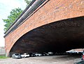
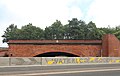
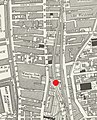
This bridge, also known as the "Grand Arch", forms part of the Great Howard Street viaduct. The line from Waterloo Dock Goods Depot used to run underneath, and the land is now a car park. Further info and pictures
Media in category "Great Howard Street bridge"
The following 9 files are in this category, out of 9 total.
-
 Great Howard Street bridge 1.jpg 5,263 × 3,187; 9.79 MB
-
 Great Howard Street bridge 2.jpg 3,884 × 2,980; 6.82 MB
-
 Great Howard Street bridge 3.jpg 4,348 × 3,104; 8.06 MB
-
 Great Howard Street bridge 4.jpg 3,838 × 3,002; 6.65 MB
-
 Great Howard Street bridge 5.jpg 4,673 × 2,954; 7.23 MB
-
 Great Howard Street bridge plaque.jpg 3,366 × 4,200; 9.74 MB
-
 Railway bridge on Great Howard Street, Liverpool (1).JPG 4,320 × 3,240; 3.77 MB
-
 Railway bridge on Great Howard Street, Liverpool (2).JPG 4,320 × 3,240; 3.8 MB
-
 Two viaducts OS 1928 w GHS bridge.jpg 446 × 554; 141 KB


.JPG)
.JPG)
