Category:Golspie Burn
Jump to navigation
Jump to search
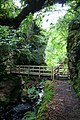
The Golspie Burn, commonly known as the Big Burn, is a stream in Sutherland, in northern Scotland. It flows down Dunrobin Glen, and into the Moray Firth, near the village of Golspie.
Media in category "Golspie Burn"
The following 14 files are in this category, out of 14 total.
-
 "Big Burn" falls - geograph.org.uk - 1599545.jpg 480 × 640; 247 KB
-
 "Colin's Bridge" across Golspie Burn - geograph.org.uk - 1599496.jpg 640 × 480; 159 KB
-
 Big Burn Footbridge - geograph.org.uk - 1413939.jpg 427 × 640; 96 KB
-
 Bridges over Golspie Burn - geograph.org.uk - 1599511.jpg 640 × 480; 196 KB
-
 Footbridge across Golspie Burn - geograph.org.uk - 1599477.jpg 480 × 640; 295 KB
-
 Ford through Golspie Burn - geograph.org.uk - 883778.jpg 640 × 480; 187 KB
-
 Golspie Burn - geograph.org.uk - 1413912.jpg 427 × 640; 119 KB
-
 Golspie Burn - geograph.org.uk - 1599471.jpg 640 × 480; 287 KB
-
 Golspie Burn Bridge - geograph.org.uk - 1413930.jpg 427 × 640; 100 KB
-
 Golspie Railway Viaduct - geograph.org.uk - 1413890.jpg 427 × 640; 82 KB
-
 Golspie Waterfall - geograph.org.uk - 1413966.jpg 640 × 427; 77 KB
-
 The Big burn water Fall - geograph.org.uk - 430453.jpg 480 × 640; 133 KB
-
 The Golspie Burn - geograph.org.uk - 430458.jpg 480 × 640; 241 KB
-
 Waterfall on The Big Burn - geograph.org.uk - 663977.jpg 456 × 640; 162 KB


