Category:Gmina Dukla
Jump to navigation
Jump to search
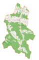
English: Gmina Dukla is an urban-rural administrative district in Krosno County, Subcarpathian Voivodeship, in south-eastern Poland, on the Slovak border. Its seat is the town of Dukla. Apart from the town of Dukla, Gmina Dukla contains the villages and settlements of Barwinek, Cergowa, Chyrowa, Głojsce, Iwla, Jasionka, Łęki Dukielskie, Lipowica, Mszana, Myszkowskie, Nadole, Nowa Wieś, Olchowiec, Ropianka, Równe, Smereczne, Teodorówka, Trzciana, Tylawa, Wietrzno, Wilsznia, Zawadka Rymanowska, Zboiska and Zyndranowa.
Polski: Gmina Dukla (dawn. m. Dukla + gminy: Nadole i Tylawa) - gmina miejsko-wiejska w województwie podkarpackim, w powiecie krośnieńskim. Siedziba gminy to Dukla.
urban-rural gmina of Poland  | |||||
| Upload media | |||||
| Instance of |
| ||||
|---|---|---|---|---|---|
| Location | Krosno County, Subcarpathian Voivodeship, Poland | ||||
| Area |
| ||||
| Different from | |||||
| official website | |||||
 | |||||
Subcategories
This category has the following 24 subcategories, out of 24 total.
Media in category "Gmina Dukla"
The following 9 files are in this category, out of 9 total.
-

-

-
 Dukla (gmina) location map.png 1,599 × 2,463; 532 KB
-
 Gmina Dukla, Poland - panoramio.jpg 10,480 × 4,096; 7.89 MB
-
 Jasionka wylana.jpg 3,264 × 1,836; 2.88 MB
-
 Krosno from 534 Hill.jpg 15,773 × 2,465; 6.96 MB
-
 Nowa Wieś Jasiołka 2015.08.23 p.jpg 2,261 × 2,805; 5.15 MB
-
 Piramida wieku Gmina Dukla.png 1,278 × 1,071; 139 KB
-
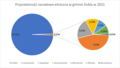 Struktura etnograficzna gminy Dukla.png 2,068 × 1,177; 137 KB
.jpg)

_location_map.png)


