Category:Geology of Alaska
Jump to navigation
Jump to search
Wikimedia category | |||||
| Upload media | |||||
| Instance of | |||||
|---|---|---|---|---|---|
| Category combines topics | |||||
| Alaska | |||||
state of the United States of America .jpg) someja da satełite in zuño     .svg)  | |||||
| Pronunciation audio | |||||
| Instance of |
| ||||
| Part of | |||||
| Location |
| ||||
| Located in or next to body of water | |||||
| Capital | |||||
| Legislative body | |||||
| Executive body | |||||
| Highest judicial authority | |||||
| Official language |
| ||||
| Anthem |
| ||||
| Head of government |
| ||||
| Inception |
| ||||
| Highest point | |||||
| Population |
| ||||
| Area |
| ||||
| Elevation above sea level |
| ||||
| Replaces |
| ||||
| Different from | |||||
| Maximum temperature record |
| ||||
| Minimum temperature record |
| ||||
| official website | |||||
 | |||||
Subcategories
This category has the following 60 subcategories, out of 60 total.
*
+
A
- Aleutian Trench (3 F)
B
C
D
E
F
G
- Geohazards in Alaska (1 F)
H
- Hydrothermal veins in Alaska (2 F)
L
M
N
O
P
Q
R
S
- Soil creep in Alaska (1 F)
U
- Unconformities in Alaska (1 F)
V
W
Y
Media in category "Geology of Alaska"
The following 54 files are in this category, out of 54 total.
-
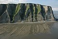
 1901. Calico Bluff-Yukon River. - NARA - 297229.jpg 3,000 × 2,982; 4.95 MB
-
 1901. Rock formation, Yukon River. - NARA - 297228.jpg 3,000 × 2,940; 4.5 MB
-
 1901. Showing rock formation-Northern Bank-Yukon River. - NARA - 297225.jpg 2,998 × 3,000; 4.26 MB
-
 Alaska patterned ground 1973.jpg 2,907 × 1,932; 1.35 MB
-
 Alaska permafrost zones.jpg 1,603 × 980; 306 KB
-
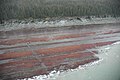
 Alluvial Gravels at the Blue Ribbon Mine Alaska.jpg 480 × 344; 32 KB
-
 Anwr marsh creek.jpg 236 × 286; 48 KB
-
 Arches and Basins of the North Slope.jpg 1,978 × 1,324; 742 KB
-
 Asperity model - 4categories.png 1,800 × 1,600; 63 KB
-
 Bonanza mine Geologic Column.PNG 201 × 546; 192 KB
-
 Bonanza Mine geologic map.PNG 495 × 540; 736 KB
-
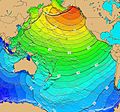 Calculated Travel Time Map for 1964 Alaska Tsunami.jpg 859 × 800; 326 KB
-
-

-
 Denali National Park geologic Terranes.png 784 × 799; 90 KB
-
 Denali National Park Geologic Time Scale.png 1,185 × 597; 168 KB
-
 Flora and Geology--St. Paul - DPLA - 3c83cc43e370af64f23b4a704e532783.JPG 1,712 × 1,368; 486 KB
-
 Flora and Geology--St. Paul - DPLA - 6a2529789f6fea62e24f1199022d7b31.JPG 1,712 × 1,368; 492 KB
-

-

-
 Frosty Volcano 3D.gif 300 × 214; 6.41 MB
-

-
 Kanuti canyon river aerial.jpg 3,000 × 2,000; 641 KB
-
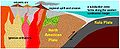 Late Cretaceous Coast Mountains plate tectonics.jpg 437 × 178; 27 KB
-
 Line4627 - Flickr - NOAA Photo Library.jpg 2,896 × 1,944; 1.04 MB
-
 Line4635 - Flickr - NOAA Photo Library.jpg 1,704 × 2,272; 870 KB
-
 Line5055 - Flickr - NOAA Photo Library.jpg 3,008 × 2,000; 1.43 MB
-
 Line5056 - Flickr - NOAA Photo Library.jpg 3,008 × 2,000; 868 KB
-
 Line5060 - Flickr - NOAA Photo Library.jpg 3,008 × 2,000; 1.35 MB
-
 Line5065 - Flickr - NOAA Photo Library.jpg 3,008 × 2,000; 1.09 MB
-
 Line5088 - Flickr - NOAA Photo Library.jpg 3,008 × 2,000; 1.14 MB
-
 Lituyanami.png 1,600 × 1,200; 2.05 MB
-

-

-
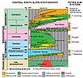 North Slope Stratigraphy.jpg 579 × 537; 418 KB
-
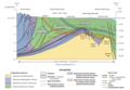 NorthSlopeGeologicCrossSection.png 1,103 × 759; 312 KB
-

-

-
 Overview of the Northern Alaska Gas Hydrate Total Petroleum System.png 831 × 456; 602 KB
-
 Page 331-cruiseofcorwin2.jpg 676 × 684; 215 KB
-
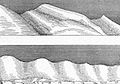
 Page 339-cruiseofcorwin.jpg 765 × 240; 90 KB
-
 Page 347-cruiseofcorwin.jpg 674 × 470; 119 KB
-
 Page 353-cruiseofcorwin.jpg 1,068 × 167; 105 KB
-

-

-

-
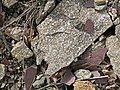
 Redoubt Andesite.jpg 1,526 × 1,388; 251 KB
-
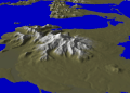
 Redoubt Volcano, Aleutian Range, Alaska, July 2015.jpg 3,648 × 2,370; 3.89 MB
-
 Rhyolitic vitrophyre.jpg 2,592 × 1,728; 2.22 MB
-
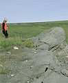
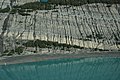
 Rock formations in Gates of the Arctic National Park.jpg 6,000 × 4,000; 15.22 MB
-
 Rolling hills (8029734742).jpg 3,246 × 2,160; 2.4 MB
-
-
 USGS ANS OilProductionMap.jpg 1,563 × 1,042; 224 KB
-
 Yukon-Tanana terrane 0Ma.jpg 975 × 815; 353 KB


_1.jpg)
_2.jpg)


_2_(17127134636).jpg)


_(20385507400).jpg)
_(20564543672).jpg)


_AND_TYPICAL_SUMMER_ARCTIC_TUNDRA._PATTERNED_GROUND,_ICE..._-_NARA_-_550392.jpg)


.jpg)
.jpg)

