Category:Geological maps of Oceania
Jump to navigation
Jump to search
Subcategories
This category has the following 7 subcategories, out of 7 total.
G
M
Media in category "Geological maps of Oceania"
The following 18 files are in this category, out of 18 total.
-
 NPS american-samoa-geologic-map.jpg 3,402 × 2,226; 1,002 KB
-
 Bulletin de la Société géologique de France (1903) (20437048565).jpg 3,200 × 1,682; 1.44 MB
-
 Geological sketch map of the Chatham Islands.jpg 1,056 × 1,737; 180 KB
-
 Lesser Sunda.png 398 × 332; 179 KB
-
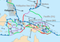 New Guinea Tectonics.png 691 × 483; 166 KB
-
 Niuafoʻou before 1943 eruption.jpg 640 × 841; 168 KB
-
 North Fiji Basin 00Ma.jpg 1,433 × 815; 317 KB
-
 North Fiji Basin 03Ma.jpg 1,433 × 815; 306 KB
-
 North Fiji Basin 09Ma.jpg 1,433 × 815; 282 KB
-
 North Fiji Basin 12Ma.jpg 1,433 × 815; 271 KB
-
 New Zealand tectonics map.jpg 372 × 445; 33 KB
-
 NZ transform (belarusian).png 370 × 443; 107 KB
-
 NZ transform (deutsch).JPG 370 × 443; 97 KB
-
 Samoa geologic map.png 1,350 × 592; 171 KB
-
 Samoan Tectonic setting.png 473 × 521; 88 KB
-
 Tahuata caldeira.svg 1,421 × 844; 63 KB
-
 UaHuka geologie.svg 797 × 560; 63 KB
-
 Boxed Woodlark Basin .png 691 × 483; 180 KB

_(20437048565).jpg)


.png)
.JPG)