Category:Gekroonde O. en W. Indis Worstvat (Haarlem)
Jump to navigation
Jump to search
| Object location | | View all coordinates using: OpenStreetMap |
|---|
 | |||||
| Upload media | |||||
| Instance of |
| ||||
|---|---|---|---|---|---|
| Location | Haarlem, North Holland, Netherlands | ||||
| Street address |
| ||||
| Heritage designation |
| ||||
 | |||||
|
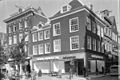
This is a category about rijksmonument number 19806
|
| Address |
|
Media in category "Gekroonde O. en W. Indis Worstvat (Haarlem)"
The following 5 files are in this category, out of 5 total.
-
 En hoekpand Grote Houtstr. - Haarlem - 20098292 - RCE.jpg 947 × 1,200; 247 KB
-
 Haarlem - Verwulft en Grote Houtstraat 64.jpg 3,264 × 2,448; 2.35 MB
-
 Haarlem Gekroond Oost en West Indies Worst Vat.jpg 2,560 × 1,920; 1.86 MB
-
 Haarlem-Worst-winkel-Verwulft.jpg 2,048 × 3,072; 2.78 MB
-
 Overzicht - Haarlem - 20098294 - RCE.jpg 1,200 × 803; 219 KB


