Category:Gedenksteen bij Oude Kerk (Putten)
Jump to navigation
Jump to search
|
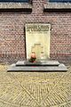
This is a category about a war memorial in the Netherlands, number: 1645
|
| Object location | | View all coordinates using: OpenStreetMap |
|---|
war memorial in Putten, the Netherlands  | |||||
| Upload media | |||||
| Instance of | |||||
|---|---|---|---|---|---|
| Commemorates | |||||
| Genre | |||||
| Location | Putten, Gelderland, Netherlands | ||||
| Street address |
| ||||
| Inception |
| ||||
| Date of official opening |
| ||||
 | |||||
Media in category "Gedenksteen bij Oude Kerk (Putten)"
The following 5 files are in this category, out of 5 total.
-
 20160707 oorlogsmonument Putten.jpg 3,456 × 5,184; 3.93 MB
-
 Putten Gedenksteen bij Oude Kerk.jpg 3,314 × 2,674; 5.75 MB
-
 Putten, gedenksteen bij de Oude Kerk foto1 2013-07-15 10.49.jpg 4,416 × 3,312; 11.56 MB
-
 Putten, herdenkingssteen de Razzia van Putten OM1645 IMG 5112 2020-04-26 13.17.jpg 4,842 × 3,047; 10.46 MB
-
 War monument church Putten.png 344 × 479; 402 KB


