Category:Gayton, Norfolk
Jump to navigation
Jump to search
English: Gayton is a small village in the west of the English county of Norfolk. It is 7.3 miles east of the town of King's Lynn, and 10.1 miles north-west of the town of Swaffham. The Gaywood River has its source just north of the village at Derby Fen. The village sides astride of the B1145 Kings Lynn to Mundesley road that dissects North Norfolk west to east.
village and civil parish in Norfolk, UK  | |||||
| Upload media | |||||
| Instance of | |||||
|---|---|---|---|---|---|
| Location | King's Lynn and West Norfolk, Norfolk, East of England, England | ||||
| Area |
| ||||
| official website | |||||
 | |||||
Media in category "Gayton, Norfolk"
The following 181 files are in this category, out of 181 total.
-
 A blustery day - farmland NE of Gayton - geograph.org.uk - 2590818.jpg 640 × 480; 141 KB
-
 A deep ditch west of Gayton - geograph.org.uk - 1324034.jpg 483 × 637; 177 KB
-

-

-

-
 A MUIOOF Lodge War Memorial in Gayton church - geograph.org.uk - 4590398.jpg 2,592 × 3,456; 3.01 MB
-
 A pond west of Gayton - geograph.org.uk - 1324038.jpg 640 × 426; 163 KB
-
-
 A stack of seasoned logs in Norfolk - geograph.org.uk - 2720093.jpg 4,320 × 3,240; 5.87 MB
-
 A well-maintained path - geograph.org.uk - 1322386.jpg 640 × 480; 132 KB
-
 A wooded corner west of Gayton - geograph.org.uk - 1322691.jpg 640 × 426; 159 KB
-
 B1145 from Old Norwich Road - geograph.org.uk - 5990172.jpg 4,608 × 3,456; 6.81 MB
-
 B1145 towards Litcham - geograph.org.uk - 5539958.jpg 640 × 480; 70 KB
-
 B1145 towards Litcham - geograph.org.uk - 5539964.jpg 640 × 480; 59 KB
-
 B1145 towards Litcham - geograph.org.uk - 5539976.jpg 640 × 480; 73 KB
-
 B1145 towards Litcham - geograph.org.uk - 5539990.jpg 640 × 480; 65 KB
-
 B1145, down into the bottom of the valley - geograph.org.uk - 5990396.jpg 4,160 × 3,120; 2.09 MB
-
 B1145, Gayton - geograph.org.uk - 5539946.jpg 640 × 480; 55 KB
-
 B1153 between Gayton and East Walton - geograph.org.uk - 2289741.jpg 760 × 570; 125 KB
-
 Barley ripening - geograph.org.uk - 873892.jpg 450 × 640; 67 KB
-
 Bend in the B1145 towards Litcham - geograph.org.uk - 5539951.jpg 640 × 480; 42 KB
-
 Brass WW1 Memorial plaque in Gayton Thorpe church - geograph.org.uk - 4590411.jpg 3,456 × 2,592; 3.79 MB
-
 Bridge House from Winch Road, Gayton - geograph.org.uk - 2289689.jpg 760 × 570; 334 KB
-
 Bridleway by Green Hill Wood, Gayton - geograph.org.uk - 2590834.jpg 640 × 480; 241 KB
-

-
 Bungalows on Winch Road - geograph.org.uk - 1323806.jpg 640 × 480; 110 KB
-
 Bus shelter, Lynn Road, Gayton - geograph.org.uk - 5981959.jpg 1,600 × 1,203; 627 KB
-
 Cereal crop near Gayton Thorpe - geograph.org.uk - 3991501.jpg 4,320 × 3,240; 6.01 MB
-
 Common Lane, south of Gayton - geograph.org.uk - 5981957.jpg 1,600 × 1,200; 941 KB
-
 Cottages in Gayton Thorpe - geograph.org.uk - 1745935.jpg 640 × 447; 128 KB
-
 Country lane to Gayton Thorpe, Norfolk - geograph.org.uk - 2768958.jpg 4,320 × 3,240; 5.45 MB
-
 Cow parsley (Anthriscus sylvestris) - geograph.org.uk - 1322423.jpg 640 × 480; 97 KB
-
 Crop field, Massingham Heath - geograph.org.uk - 5539984.jpg 640 × 480; 60 KB
-
 Downhill lane to Gayton Thorpe in Norfolk - geograph.org.uk - 2720117.jpg 4,320 × 3,240; 6.01 MB
-

-

-
 East Walton Common, aerial 2015 - geograph.org.uk - 4485166.jpg 640 × 334; 44 KB
-
 Eastgate Drove south of the Old Workhouse - geograph.org.uk - 2719345.jpg 4,320 × 3,240; 5.61 MB
-
 English cottage garden in Gayton - geograph.org.uk - 5850641.jpg 1,600 × 1,067; 551 KB
-

-
 Field gate by Well Hall Farm - geograph.org.uk - 1322381.jpg 640 × 480; 93 KB
-
 Field gate with a postcode - geograph.org.uk - 2289739.jpg 760 × 570; 146 KB
-
 Field-woodland boundary, Gayton - geograph.org.uk - 2590837.jpg 640 × 480; 233 KB
-
 Former chapel, Gayton - geograph.org.uk - 4127114.jpg 4,320 × 3,240; 2.92 MB
-

-
 G VI R postbox No PE32 318 - geograph.org.uk - 2289708.jpg 450 × 600; 196 KB
-
 Gayton church - geograph.org.uk - 4750788.jpg 531 × 800; 126 KB
-
 Gayton church - geograph.org.uk - 4750792.jpg 531 × 800; 110 KB
-
 Gayton Hall Norfolk - southern boundary - geograph.org.uk - 2720130.jpg 4,320 × 3,240; 5.54 MB
-
 Gayton Mill - geograph.org.uk - 2289715.jpg 760 × 570; 141 KB
-
 Gayton Mill - geograph.org.uk - 4127159.jpg 4,320 × 3,240; 3.65 MB
-
 Gayton Mill - geograph.org.uk - 5539944.jpg 640 × 480; 51 KB
-
 Gayton Mill.jpg 545 × 639; 95 KB
-
 Gayton Social Club - geograph.org.uk - 4750796.jpg 800 × 531; 109 KB
-
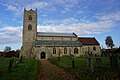
 Gayton St. Nicholas' church - geograph.org.uk - 3917974.jpg 640 × 480; 71 KB
-
 Gayton Thorpe Common, aerial 2015 - geograph.org.uk - 4485198.jpg 640 × 427; 48 KB
-
 Gayton Thorpe St. Mary's church - geograph.org.uk - 3917977.jpg 640 × 480; 64 KB
-
 Gayton Thorpe village sign (detail) - geograph.org.uk - 4589216.jpg 1,024 × 768; 285 KB
-
 Gayton Thorpe Village Sign - geograph.org.uk - 5412274.jpg 640 × 480; 109 KB
-
 Gayton Thorpe village sign near the village pond - geograph.org.uk - 4589214.jpg 1,024 × 768; 345 KB
-
 Gayton Thorpe, Norfolk - St Mary's Church - geograph.org.uk - 5621227.jpg 5,184 × 2,920; 1.25 MB
-
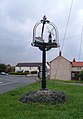
 Gayton Village Sign - geograph.org.uk - 5412252.jpg 480 × 640; 76 KB
-
 Gayton Village Sign.png 411 × 360; 145 KB
-
 Green Hill not living up to its name - geograph.org.uk - 5989861.jpg 4,608 × 3,456; 6.74 MB
-
 Green Hill small quarry - geograph.org.uk - 2032766.jpg 1,536 × 2,048; 1 MB
-
 Green Hill Wood - geograph.org.uk - 873601.jpg 640 × 480; 51 KB
-
 Gulf filling station, Gayton - geograph.org.uk - 5981962.jpg 1,600 × 1,066; 593 KB
-

-
 Harvested field by Brink Hill, Gayton - geograph.org.uk - 2590795.jpg 640 × 480; 141 KB
-
 Harvested field by Long Belt, Gayton - geograph.org.uk - 2590812.jpg 640 × 480; 201 KB
-
-
 House on Lynn Road, Gayton - geograph.org.uk - 2889697.jpg 4,320 × 3,240; 5.68 MB
-
 Houses and mill, Gayton - geograph.org.uk - 5539939.jpg 640 × 480; 49 KB
-
 Inquisitive horse near Gayton Thorpe - geograph.org.uk - 2889701.jpg 4,320 × 3,240; 5.83 MB
-
 K6 telephone box and postbox - geograph.org.uk - 1745943.jpg 480 × 640; 165 KB
-
 Lane from Green Hill to Eastgate Drove - geograph.org.uk - 2719368.jpg 4,320 × 3,240; 5.83 MB
-
 Lane to Gayton Thorpe, Norfolk - geograph.org.uk - 2768913.jpg 4,320 × 3,240; 5.88 MB
-
 Lane to Green Hill which can be seen on the horizon - geograph.org.uk - 5989860.jpg 4,400 × 3,300; 2.67 MB
-
 Lane to Soigne Farm, Gayton Thorpe - geograph.org.uk - 3991484.jpg 4,320 × 3,240; 5.96 MB
-
 Lane up to Green Hill - geograph.org.uk - 2719380.jpg 4,320 × 3,240; 5.68 MB
-
 Life after death in Gayton, Norfolk - geograph.org.uk - 2768972.jpg 4,320 × 3,240; 5.16 MB
-
 Logs by a remote track in Norfolk - geograph.org.uk - 2720098.jpg 4,320 × 3,240; 5.91 MB
-
 Logs in Long Plantation - geograph.org.uk - 3991902.jpg 4,320 × 3,240; 5.59 MB
-
 Lynn Road (B1145), Gayton - geograph.org.uk - 5539617.jpg 640 × 480; 63 KB
-
 Lynn Road, Gayton - geograph.org.uk - 5850650.jpg 1,600 × 1,035; 308 KB
-
 Maize crop, Massingham Heath - geograph.org.uk - 5539955.jpg 640 × 480; 63 KB
-
 Marl pit on Massingham Heath - geograph.org.uk - 2768850.jpg 4,320 × 3,240; 5.58 MB
-
 Narrow lane near Gayton in Norfolk - geograph.org.uk - 2720103.jpg 4,320 × 3,240; 6.02 MB
-
 Norfolk countryside - geograph.org.uk - 763072.jpg 640 × 480; 71 KB
-
 Norfolk countryside east of Gayton - geograph.org.uk - 2768901.jpg 4,320 × 3,240; 5.47 MB
-
 Norfolk green - geograph.org.uk - 3991495.jpg 4,320 × 3,240; 5.94 MB
-
 Not normal for Norfolk - geograph.org.uk - 2719628.jpg 4,320 × 3,240; 5.54 MB
-
 Old Norwich Road rising from the valley floor - geograph.org.uk - 5990459.jpg 4,072 × 3,054; 3.84 MB
-
 On the edge of Gravelpit Plantation - geograph.org.uk - 4088020.jpg 4,320 × 3,240; 5.98 MB
-
 Overgrown marl pit on Massingham Heath - geograph.org.uk - 2768890.jpg 4,320 × 3,240; 6.02 MB
-

-

-
 Permissive footpath near Gayton Thorpe - geograph.org.uk - 3991491.jpg 4,320 × 3,240; 5.58 MB
-
 Pig food hoppers beside the Old Norwich Road - geograph.org.uk - 5990397.jpg 4,608 × 3,456; 3.45 MB
-
 Ploughing in February - geograph.org.uk - 4343023.jpg 640 × 480; 311 KB
-
 Public footpath to Well Hall Lane - geograph.org.uk - 1322392.jpg 640 × 480; 110 KB
-
 Pumping Station north of Gayton - geograph.org.uk - 5990067.jpg 4,608 × 3,456; 5.95 MB
-
 Rapeseed stubble near Gravelpit Plantation - geograph.org.uk - 4088070.jpg 4,320 × 3,240; 6.06 MB
-
 Remains of a dead tree on woodland edge - geograph.org.uk - 1323840.jpg 640 × 480; 130 KB
-
 Restricted byway east of Gayton Thorpe - geograph.org.uk - 2890897.jpg 4,320 × 3,240; 5.69 MB
-

-
 Road passing through Gayton - geograph.org.uk - 4750803.jpg 1,024 × 680; 263 KB
-
 Road to Soigne Farm - geograph.org.uk - 3991471.jpg 4,320 × 3,240; 5.91 MB
-
 Rougham Belt - geograph.org.uk - 5539967.jpg 640 × 480; 57 KB
-

-
 Sign for the Crown Inn, Gayton - geograph.org.uk - 5539625.jpg 512 × 640; 43 KB
-

-
 Soigne Wood - geograph.org.uk - 754501.jpg 640 × 480; 59 KB
-
 Soigne Wood near Gayton Thorpe - geograph.org.uk - 3991724.jpg 4,320 × 3,240; 5.69 MB
-

-
 St Nicholas Church, Gayton - geograph.org.uk - 5978731.jpg 1,064 × 1,600; 408 KB
-
 St Nicholas Church, Gayton - geograph.org.uk - 5978733.jpg 1,600 × 1,064; 490 KB
-
 St Nicholas Church, Gayton - geograph.org.uk - 5978735.jpg 1,600 × 1,064; 488 KB
-
 St Nicholas Church, Gayton - geograph.org.uk - 5978738.jpg 1,600 × 1,064; 362 KB
-
 St Nicholas Church, Gayton - geograph.org.uk - 5978946.jpg 927 × 1,600; 728 KB
-
 St Nicholas Church, Gayton - geograph.org.uk - 5978947.jpg 1,064 × 1,600; 420 KB
-
 St Nicholas Church, Gayton - geograph.org.uk - 5978949.jpg 1,600 × 1,064; 1.17 MB
-
 St Nicholas Church, Gayton - geograph.org.uk - 5978954.jpg 1,600 × 1,064; 676 KB
-
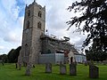 St Nicholas' church, Gayton (1) - geograph.org.uk - 4127128.jpg 4,320 × 3,240; 2.95 MB
-
 St Nicholas' church, Gayton (2) - geograph.org.uk - 4127129.jpg 4,320 × 3,240; 2.97 MB
-
 Stack of logs by Long Belt, Gayton - geograph.org.uk - 2590810.jpg 640 × 480; 154 KB
-
 Stained glass window, Gayton church - geograph.org.uk - 4750800.jpg 800 × 531; 100 KB
-
 Stained glass windows, Gayton church - geograph.org.uk - 4750799.jpg 800 × 531; 182 KB
-
 Stubble field and off the B1145 - geograph.org.uk - 5539962.jpg 640 × 480; 75 KB
-
 Stubble field east of Gayton - geograph.org.uk - 5539948.jpg 640 × 480; 46 KB
-
 Stubble field towards Rougham Belt - geograph.org.uk - 5539972.jpg 640 × 480; 47 KB
-
 Stubble field towards Tinkers' Belt - geograph.org.uk - 5539981.jpg 640 × 480; 67 KB
-

-
 Sunset over Massingham Heath in Norfolk - geograph.org.uk - 5586972.jpg 4,608 × 3,456; 4.77 MB
-
 The Crown Inn, Gayton - geograph.org.uk - 4127136.jpg 4,320 × 3,240; 2.95 MB
-
 The Crown Inn, Gayton - geograph.org.uk - 5539623.jpg 640 × 480; 73 KB
-
 The Crown, Gayton - geograph.org.uk - 4750802.jpg 800 × 531; 102 KB
-
 The edge of Fisher's Wood - geograph.org.uk - 2719003.jpg 4,320 × 3,240; 5.73 MB
-
 The Medieval Village of Well (Site off) - geograph.org.uk - 2719016.jpg 4,320 × 3,240; 5.27 MB
-
 The memorial brass of Capt. The Honorable D H Marsham - geograph.org.uk - 4590405.jpg 2,592 × 3,456; 3.11 MB
-
 The old Freebridge Lynn Union workhouse - geograph.org.uk - 5990076.jpg 4,608 × 3,456; 3.21 MB
-
 The old Freebridge Lynn Union workhouse, main entrance - geograph.org.uk - 5990079.jpg 4,608 × 3,456; 2.82 MB
-
 The Rampant Horse pub (closed), Gayton - geograph.org.uk - 4127106.jpg 4,320 × 3,240; 2.99 MB
-

-

-
 Tinkers belt on West Acre Estate - geograph.org.uk - 2774294.jpg 1,728 × 2,592; 531 KB
-
 To the B1145 from Gayton Thorpe - geograph.org.uk - 1745939.jpg 640 × 480; 150 KB
-
 Track beside the pumping station - geograph.org.uk - 5990071.jpg 3,760 × 2,820; 2.03 MB
-
 Track from Gayton Thorpe - geograph.org.uk - 3991738.jpg 4,320 × 3,240; 6.02 MB
-
 Track over Green Hill - geograph.org.uk - 2719618.jpg 4,320 × 3,240; 5.86 MB
-
 Track skirting pasture - geograph.org.uk - 1323832.jpg 640 × 480; 107 KB
-
 Track to Stowbrough Heath - geograph.org.uk - 754484.jpg 480 × 640; 66 KB
-
 Track to Tinkers' Belt on Massingham Heath - geograph.org.uk - 2768883.jpg 4,320 × 3,240; 5.92 MB
-
 Trees near Gayton in Norfolk - geograph.org.uk - 2720109.jpg 4,320 × 3,240; 5.69 MB
-
 Trees on Massingham Heath - geograph.org.uk - 2768820.jpg 4,320 × 3,240; 5.68 MB
-
 UK Gayton (Norfolk) (SideA).jpg 745 × 1,693; 206 KB
-
 UK Gayton (Norfolk) (SideB).jpg 751 × 1,783; 194 KB
-
-
-
 Victorian postbox on Lynn Road, Gayton - geograph.org.uk - 5557318.jpg 2,848 × 2,136; 1.2 MB
-
 View across the churchyard in Gayton - geograph.org.uk - 1897691.jpg 640 × 480; 132 KB
-
 View along Middle Belt, Gayton - geograph.org.uk - 2590815.jpg 640 × 480; 143 KB
-
 View along Middle Belt, Gayton - geograph.org.uk - 2590824.jpg 640 × 480; 166 KB
-

-
 View from Gravelpit Plantation, Gayton - geograph.org.uk - 2590801.jpg 640 × 480; 175 KB
-
 View north along Winch Road - geograph.org.uk - 1323802.jpg 640 × 480; 106 KB
-
 View toward Brink Hill, Gayton - geograph.org.uk - 2590819.jpg 640 × 480; 132 KB
-
 View towards Long Belt, Gayton - geograph.org.uk - 2590799.jpg 640 × 480; 146 KB
-
 View west along Well Hall Lane - geograph.org.uk - 1322377.jpg 640 × 480; 97 KB
-
 Waiting to be used again - geograph.org.uk - 754519.jpg 640 × 480; 87 KB
-
 Water trough in pasture - geograph.org.uk - 1323826.jpg 640 × 508; 87 KB
-
 Welcome to Gayton on Winch Road - geograph.org.uk - 2289680.jpg 760 × 570; 203 KB
-
 Well Hall Farm, Gayton - geograph.org.uk - 5990062.jpg 4,608 × 3,456; 3.16 MB
-
 Whitehouse Service Station, Gayton - geograph.org.uk - 5539612.jpg 640 × 480; 58 KB
-
 Wizard Cottage south of Gayton - geograph.org.uk - 2889695.jpg 4,320 × 3,240; 5.73 MB
-
 Wooded farmland northwest of Gayton - geograph.org.uk - 1324052.jpg 640 × 426; 79 KB
-
 Wooden barn at Gayton Thorpe (geograph 6630167).jpg 1,024 × 768; 177 KB
-
 Woodland, Massingham Heath - geograph.org.uk - 5539987.jpg 640 × 480; 63 KB
-
 WW1 memorial plaque - geograph.org.uk - 5971448.jpg 1,293 × 1,600; 477 KB
-
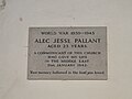 WW2 memorial in Gayton Thorpe church - geograph.org.uk - 4590408.jpg 3,456 × 2,592; 3.59 MB
-
 Gayton village sign - geograph.org.uk - 262346.jpg 445 × 640; 98 KB


_-_geograph.org.uk_-_1322423.jpg)


_-_geograph.org.uk_-_4589216.jpg)


,_Gayton_-_geograph.org.uk_-_5539617.jpg)


_-_geograph.org.uk_-_5412265.jpg)


_-_geograph.org.uk_-_4127128.jpg)
_-_geograph.org.uk_-_4127129.jpg)


_-_geograph.org.uk_-_2719016.jpg)


,_Gayton_-_geograph.org.uk_-_4127106.jpg)


_(SideA).jpg)
_(SideB).jpg)


.jpg)


