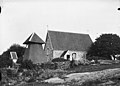
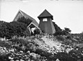
Category:Fullestads kyrka
Jump to navigation
Jump to search
| Object location | | View all coordinates using: OpenStreetMap |
|---|
church building in Vårgårda Municipality, Sweden  | |||||
| Upload media | |||||
| Instance of | |||||
|---|---|---|---|---|---|
| Location | Vårgårda Municipality, Västra Götaland County, Sweden | ||||
| Diocese | |||||
| Has use |
| ||||
| Occupant | |||||
| Heritage designation |
| ||||
 | |||||
Svenska: Fullestads kyrka tillhör Lena församling, Vårgårda pastorat, Kullings kontrakt, Skara stift / Diocese of Skara.
|
This is a category about an ecclesiastical monument in Sweden, number 21300000010831 in the RAÄ buildings database.
|
|
This is a category about a protected building in Sweden, number 21400000549745 in the RAÄ buildings database.
|
Media in category "Fullestads kyrka"
The following 14 files are in this category, out of 14 total.
-
 Fullestads kyrka - KMB - 16000200155390.jpg 834 × 600; 88 KB
-
 Fullestads kyrka - KMB - 16000200155391.jpg 839 × 600; 88 KB
-
 Fullestads kyrka - KMB - 16000200155392.jpg 856 × 600; 104 KB
-
 Fullestads kyrka - KMB - 16000200155393.jpg 424 × 600; 39 KB
-
 Fullestads kyrka - KMB - 16000200155394.jpg 971 × 600; 98 KB
-
 Fullestads kyrka - KMB - 16000200155395.jpg 953 × 600; 98 KB
-
 Fullestads kyrka - KMB - 16000200155396.jpg 994 × 600; 69 KB
-
 Fullestads kyrka - KMB - 16000200155397.jpg 973 × 600; 64 KB
-
 Fullestads kyrka - KMB - 16000200155398.jpg 342 × 600; 25 KB
-
 Fullestads kyrka med gravar.JPG 3,456 × 2,304; 4.79 MB
-
 Fullestads kyrka med grind.JPG 3,456 × 2,304; 4.79 MB
-
 Fullestads kyrka med ingång.JPG 3,456 × 2,304; 3.99 MB
-
 Fullestads kyrka old1.jpg 836 × 600; 100 KB
-
 Fullestads kyrka old2.jpg 811 × 600; 113 KB


Categories:
- 14th-century architecture in Vårgårda Municipality
- 14th-century churches in Västra Götaland County
- Churches in the Diocese of Skara
- Stone churches in Vårgårda Municipality
- Churches in Västergötland
- Kullings härad
- Listed churches in Vårgårda Municipality
- Fieldstone churches in Västra Götaland County
- White churches in Sweden